Stanway & Snowshill circular
Cotswolds Walk
Region - Cotswolds
County/Area - Gloucestershire
Author - Lou Johnson
Length - 8.0 miles / 13 km Ascent - 980 feet / 297 metres
Time - 5 hours 0 minutes Grade - moderate
Maps 

| Ordnance Survey Explorer OL45 | Sheet Map | 1:25k | BUY |
| Anquet OS Explorer OL45 | Digital Map | 1:25k | BUY |
| Ordnance Survey Landranger 150 | Sheet Map | 1:50k | BUY |
| Anquet OS Landranger 150 | Digital Map | 1:50k | BUY |
Walk Route Description
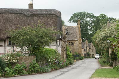
Click image to visit gallery of 6 images.
The Cotswolds is an area renowned for its attractive and historic villages scattered across undulating hills. This walk includes three such villages with some interesting buildings connected by very pleasant rural landscapes.
The start is the village of Stanton situated a couple of miles south of Broadway just off the B4632 road to Winchcombe. There is a small car park adjacent to the cricket ground (Grid ref. SP067343). Exit the car park and turn right. Turn right at the first road junction and walk south past attractive cottages built from the local stone. Where the road bears sharp left take the footpath signed "Cotswold Way".
This leads across pleasant pastures towards Stanway. As you near Stanway the fields are dotted with mature trees forming very attractive open parkland. Reaching a lane turn left into Stanway. Walking past the church and attractive gatehouse and just after the road turns right look out for the Cotswold Way sign on your left. Take this path to reach a main road.
Turn left along the road, which has the benefit of a footway, and climb steadily uphill. Where the road bends sharp right go straight ahead which is marked with some useful supplementary signs and enter Longpark Wood. The path is muddy in places but do not stray far from the fields on your left hand side. Reaching a stream (Grid ref. SP 074 323) care is needed as tracks and paths diverge in all directions. The best advice is to stay in the valley heading roughly northeast. The track begins to climb more steeply to reach the site of Parks Farm (Grid ref. SP 080 328).
Go straight ahead ignoring the signed path on your left to reach another junction of tracks and a path (Grid ref. SP 082 330). The temptation is to stay on the track but you need to follow the waymarked path northeast across fields towards Snowshill. A further junction of paths needs to be negotiated carefully before you reach a lane (Grid ref. SP 088 334). Turn right down the lane into Snowshill.
The village of Snowshill has a pub, a church and the well known Snowshill Manor that dates from Tudor times. Having explored the village return along the lane used on the approach. At Oat Hill (Grid ref. SP 095 337) take the steep concrete track that descends right into the valley. This track is signed as a right of way. There have been some significant diversions to the right of way so follow the signs and these should lead you into a lane at Great Brockhampton Farm. Turn right along the lane past the farm.
The lane continues becoming a rougher track after 800 metres with good views across the valley back to Snowshill. Reaching the corner of Buckland Wood (Grid ref. SP 089 352) leave the track to take the footpath on your left that makes a shortcut across a field to join the Cotswold Way. Turn left along this National Trail for about 400 metres and then turn right down a track that leads towards Laverton. (Note the start is partly hidden and care needs to be taken so as not to miss this bridleway).
The track descends towards Laverton with expansive views ahead to the Vale of Evesham and beyond. Reaching a junction of paths (Grid ref. SP 077 356) turn left. This path leads across pastures towards Stanton. As the village is approached take the left hand fork. This path leads you onto the main village street with its many stone cottages. Turn right past the church. Turn right again at the road junction and this will lead you back to the start.
Other walks nearby
| Walk 3327 | Temple Guiting & Cutsdean from Stanway | moderate | 10.0 miles |
| Walk 2094 | Snowshill Circular | easy | 4.4 miles |
| Walk 3072 | Broadway, Stanton & Laverton | easy/mod | 7.5 miles |
| Walk 3250 | The Broadway Tower from Broadway | easy/mod | 5.0 miles |
| Walk 3064 | Hailes, Beckbury & Sudeley from Winchcombe | moderate | 10.0 miles |
| Walk 3065 | Cleeve Common & Belas Knap from Winchcombe | moderate | 10.0 miles |
| Walk 1308 | Broadway & Chipping Campden | moderate | 11.0 miles |
| Walk 1949 | Nottingham Hill | easy/mod | 4.5 miles |
| Walk 2495 | Bredon Hill Circular | moderate | 10.6 miles |
| Walk 2402 | Bredon Hill from Elmley Castle | easy/mod | 5.5 miles |
Recommended Books & eBooks
The Cotswold Way
 Guidebook to walking the Cotswold Way National Trail. Between Chipping Campden and Bath, the 102 mile route explores the Cotswolds AONB. Described in both directions over 13 stages, the Cotswold Way can be walked year round and is suitable for beginner trekkers. Includes separate OS 1:25,000 map booklet of the route.
More information
The Cotswold Way Map Booklet
 Map of the 102 mile (163km) Cotswold Way National Trail, between Chipping Camden and Bath. This booklet is included with the Cicerone guidebook to the trail, and shows the full route on OS 1:25,000 maps. The trail typically takes two weeks to walk, and is suitable for walkers at all levels of experience.
More information
Messaging & Social Media
Message Walking Britain and follow the latest news.

Mountain Weather
Stay safe on the mountains with detailed weather forecasts - for iOS devices or for Android devices.