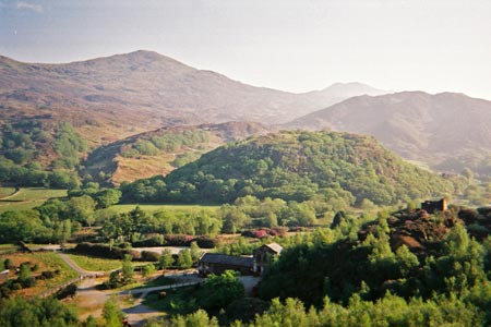
Mynydd Sygun from Beddgelert
Snowdonia/Eryri Walk
Nat Park - Snowdonia - Moelwyns Moel Siabod Cnicht
County/Area - Gwynedd
Author - Peter Smyly
Length - 4.5 miles / 7.3 km Ascent - 865 feet / 262 metres
Time - 3 hours 10 minutes Grade - moderate
Maps 

| Ordnance Survey Explorer OL17 | Sheet Map | 1:25k | BUY |
| Anquet OS Explorer OL17 | Digital Map | 1:25k | BUY |
| Ordnance Survey Landranger 115 | Sheet Map | 1:50k | BUY |
| Anquet OS Landranger 115 | Digital Map | 1:50k | BUY |
Walk Route Description
Click image to visit gallery of 5 images.
This is a relatively short Snowdonia (Eryri) walk which may appeal to visitors to the Beddgelert area who are not looking to climb the higher peaks or to those looking for a walk to occupy a couple of hours or so only. Mynydd Sygun is a minor top which occupies the skyline to the south-east of the Welsh village of Beddgelert. In good visibility, it offers excellent views of some of the better-known Welsh mountains including the Moel Hebog group, the Nantlle Ridge, Yr Aran, the Snowdon Horseshoe, Cnicht and the Moelwyns.
From the centre of Beddgelert, follow the A498 main road out of the village to the north east and cross a bridge over the river on the right. On the other side of the river, pass through a wooden gate on the left that leads to a paved path that passes between rhododendrons alongside the Afon Glaslyn (river). On emerging through a kissing gate with another bridge on the left, take a lane on the right with a sign saying "Sat Nav Error" on a tree to the right. Follow the country lane ahead past a house on the right and a camp site on the left. Another half a mile further on leads to the Sygun Copper Mine and a signed public footpath leads off to the right just before it. The path leads uphill through rocks and heather as the views of the Moel Hebog group in particular appear to the west. Take the right path at a fork and shortly after this point, the skyline is reached, revealing Cnicht and the Moelwyns ahead beyond a series of foothills and the Cwm Bychan valley. Follow the path along the ridge to the top, marked by a small cairn.
The descent route offers confirmation that it is better to do the route in a clockwise direction as it enables the walker to have a fine view looking down on Beddgelert ahead, but also the path is very steep in the latter stages with some parts of it requiring a bit of clambering over rocky sections which are more easily managed going down than up. At the right time of year, there are blossoming rhododendrons and bluebells on the way down to lend colour to the foreground. The path emerges on a secondary road and the centre of the village of Beddgelert is just a few minutes walk away.
Other walks nearby
| Walk 1427 | Craflwyn circular from near Beddgelert | easy/mod | 2.5 miles |
| Walk 3058 | Llyn yr Adar & Llyn Edno from near Bethania | moderate | 9.0 miles |
| Walk 1192 | Yr Aran | mod/hard | 6.5 miles |
| Walk 1103 | Snowdon & Cwm Llan horseshoe | very hard | 13.0 miles |
| Walk 2290 | Snowdon via the Watkin Path & South Ridge from Bethania | mod/hard | 8.0 miles |
| Walk 1136 | Yr Aran (Route 2) | moderate | 5.5 miles |
| Walk 1515 | Tops and Tarns of the Moelwyns | mod/hard | 11.0 miles |
| Walk 2590 | Nantlle Ridge Walk from Rhyd Ddu (Route A) | moderate | 6.0 miles |
| Walk 2797 | Yr Aran and Snowdon from Rhyd-Ddu | mod/hard | 8.5 miles |
| Walk 3509 | Nantlle Ridge from Rhyd Ddu (Route B) | mod/hard | 8.3 miles |
Recommended Books & eBooks
The Cambrian Way
 Guidebook to the Cambrian Way, a challenging three-week mountain trek through Wales from Cardiff to Conwy. The 470km un-waymarked route is presented from south to north. Often sticking to long, beautiful ridgelines, it crosses wild and rugged terrain and visits many of Wales's highest mountains, including Snowdon.
More information
Snowdonia: 30 Low-level and easy walks - North
 Guidebook describing 30 walks in Snowdonia, Wales. Routes are mostly low level and on clear paths and showcase the region's beautiful scenery and rich history and culture. Part of a 2-volume set, this northern volume includes the Snowdon area, the Ogwen and Conwy Valleys, Betws-y-Coed, Beddgelert, Ffestiniog and the coast.
More information
Messaging & Social Media
Message Walking Britain and follow the latest news.

Mountain Weather
Stay safe on the mountains with detailed weather forecasts - for iOS devices or for Android devices.