Walk 3091 - printer friendly version
Ingleton Waterfalls Walk Walk
Author - Lou Johnson
Length - 4.3 miles / 7 km
Ascent - 750 feet / 227 metres
Grade - easy
Start - OS grid reference SD694730
Lat 54.151901 + Long -2.4700137
Postcode LA6 3HX (approx. location only)
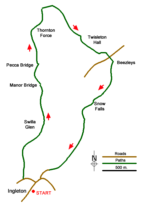
The Ingleton Waterfalls Walk in the Yorkshire Dales was described by A W Wainwright as "the most delightful walk in the country?" The walk includes two valleys with a variety of waterfalls and a stretch of open limestone country. Who could ask for more? Starting from Ingleton, the route is normally undertaken in a clockwise direction and takes a few hours to complete and is perhaps best seen after heavy rain. The walk is also an attractive proposition even in periods of dry weather.
Ingleton village offers a range of parking opportunities. You can use the main pay and display car park adjacent to the excellent information centre (grid ref. SD694730), on-street parking (in short supply at busy weekends) or the large car park at the entrance to the walk (grid ref. SD693732). Whichever option you choose, make your way to the entrance to the walk, which is signed throughout the village. There is a charge of £6 for adults which includes free parking at the start of the walk.
Directions for the walk are not necessary as the path is easy to follow and well maintained. There are many steps to negotiate and the route is not ideal for those with pushchairs. Young children need careful 'management' as there are several steep drops off the path into the rivers. Refreshments are available at the start of the walk and twice during the walk (in season). Often there is also an ice-cream van parked conveniently on Twisleton lane.
After parking follow the River Twist upstream through Swilla Glen passing through pleasant woodland. The entrance fee includes a map which highlights the main waterfalls to be encountered along the way. The path climbs steadily and makes two crossings of the river. Eventually you reach open country and Thornton Force the highest waterfall on the route. The path then leaves the river valley and climbs up to Twisleton Lane.
The route turns right along the walled lane and continues past Twisleton Hall and down to Beezleys. On this section, you have some fine views of Ingleborough. From Beezleys the path descends alongside the River Doe passing more waterfalls on the way back to the start. The path finishes in Ingleton village with a plentiful supply of refreshment opportunities. If you have parked at the entrance to the walk then you will need to walk down to the car park from the village.
Messaging & Social Media
Message Walking Britain and follow the latest news.

Mountain Weather
Stay safe on the mountains with detailed weather forecasts - for iOS devices or for Android devices.