Haystacks, Twelve Apostles & Idol Stone of Ilkley Moor
West Yorkshire Walk
County/Area - West Yorkshire - Bradford
Author - Dave Melling
Length - 4.5 miles / 7.3 km Ascent - 600 feet / 182 metres
Time - 2 hours 50 minutes Grade - easy/mod
Maps 

| Ordnance Survey Explorer 297 | Sheet Map | 1:25k | BUY |
| Anquet OS Explorer 297 | Digital Map | 1:25k | BUY |
| Ordnance Survey Landranger 104 | Sheet Map | 1:50k | BUY |
| Anquet OS Landranger 104 | Digital Map | 1:50k | BUY |
Walk Route Description
Click image to visit gallery of 7 images.
For over 4,000 years our ancestors have lived and farmed on Ilkley Moor. This fascinating walk visits some of the scattered remains of their boundary markers, enclosures, cairns, and the strange cup and ring carved stones.
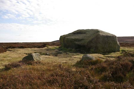
Starting from the car park at grid reference SE133467 walk towards the quarry and bear left up the path to the flat area above the quarry. Take the track going slightly left and head for the next ridge until the large isolated Haystack Rock is reached. The rock has the shape of a traditional haystack. Closer inspection reveals that carved onto the surface of the sloping sides are seventy cups, some with rings and connecting grooves.
There are over 280 carved cup and rings stones in the upland Moor between the Rivers Aire and Wharfe. According to archaeologists they date from the late Neolithic to the Early Bronze Age around 2500BC. It is thought that some may date from an even earlier time. Some of the carvings are simple collections of two or three cups others have strange interlinking designs of cups, rings and grooves. There are many theories about their meanings - are they tribal boundaries, maps or religious texts? Nobody has cracked the code and hopefully nobody will. The interest lies in discovering the carvings and speculating on what our ancestors were doing.
Follow the track right following the ridge and then curving round left. Look out for other smaller stones with cups and rings. The track eventually reaches the bronze age enclosures alongside Backstones Beck. The site was excavated during the 1980's. The items found suggest that the site has been used from about 3,000BC as hunting camp. Part of an embankment and two hut circles have been reconstructed. These were probably in use between 800BC and 500BC. Hidden in the vegetation are another three carved stones.
Follow the track up the moor, cross the line of shooting butts and go left onto the board walk of the main track from Ilkley. Head for the solitary upright stone on the next ridge. This stone is known as the Lanshaw Lad. It marks the early 19th Century boundary between Burley and Ilkley. Follow the track south east to the Twelve Apostles stone circle. The circle has 12 stones now but 20 stones were noted by Victorian writers. From this spot there are good views of Wharfedale towards Otley.
Continue south on the track until a small cairn is reached about 130 metres from the stone circle. Follow the track going eastwards along the side of the ditch, crossing over the small bridge. Take care as the ground can be very boggy at this point and it is easy to sink in up to the knees. Follow the track past High Lanshaw Dam and onto a rocky outcrop on the ridge on the right (Grid ref. SE136446). Just beyond this there is a shooting hut. Behind which is the Grubstones stone circle. There is a lot of speculation whether this is a burial cairn, a court meeting place or boundary point.
Return along the path to the rocky outcrop and head north on a well worn path, down hill to a stream. Cross over the stream at the small footbridge, up the bank and along the side of the ridge, following a faint track above the boggy ground to reach the corner of High Lanshaw Dam. Head for the Lanshaw Lass boundary stone marked by a yellow post on the ridge in front. The stone lies in hollow close to the post.
The walk continues along the well trodden path going north easterly following the yellow marker posts to the rock of Green Crag. Descend from the crag and follow a path going left to Idol Rock. This is a large upright stone with naturally worm grooves along its top edge. Just a few metres further along the path is the Idol Stone another of the cup and ring stones.
From the Idol Stone follow the well worn path to the Haystack Rock and then down the hill northwards back to the car park at the Cow and Calf. On your journey back keep a look out for even more carved stones!
Other walks nearby
| Walk 2319 | Ilkley to Bingley | easy/mod | 7.0 miles |
| Walk 1905 | Beamsley Beacon and Bolton Abbey | moderate | 10.0 miles |
| Walk 1952 | Five Rise Locks and the River Aire, Bingley | easy | 5.3 miles |
| Walk 2942 | Below Silsden Moor | easy/mod | 6.8 miles |
| Walk 1408 | Saltaire - the model village | easy | 1.5 miles |
| Walk 1572 | Swinsty Reservoir | easy | 3.0 miles |
| Walk 3079 | Silsden Reservoir circular | easy | 6.0 miles |
| Walk 1405 | Thruscross Reservoir & Kex Gill Moor | easy/mod | 8.5 miles |
| Walk 2802 | Shipley to Ilkley via Ilkley Moor | moderate | 10.8 miles |
| Walk 2574 | Valley of Desolation & Barden Fell | moderate | 11.0 miles |
Recommended Books & eBooks
No suggestions for this area.Messaging & Social Media
Message Walking Britain and follow the latest news.

Mountain Weather
Stay safe on the mountains with detailed weather forecasts - for iOS devices or for Android devices.