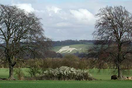
Whipsnade & Codling Bank from Robertson Corner
Chilterns Walk
Region - Chilterns
County/Area - Bedfordshire
Author - Lou Johnson
Length - 4.3 miles / 7 km Ascent - 400 feet / 121 metres
Time - 2 hours 30 minutes Grade - easy
Maps 

| Ordnance Survey Explorer 181 | Sheet Map | 1:25k | BUY |
| Anquet OS Explorer 181 | Digital Map | 1:25k | BUY |
Walk Route Description
Click image to see photo description.
The start of this Bedfordshire walk is the car park on the west side of Robertson Corner (grid ref. TL008197). After parking walk south following the waymarked bridleway (Icknield Way Trail). Continue on the bridleway through meadowland to reach a gate (grid ref. SP999185). Turn left staying with the Icknield Way Trail following a sunken lane. Directly after a house (grid ref. TL005180), turn left through a gap in the fence. You are still on the Icknield Way Trail. Go through a kissing gate, walk through the field with the fence on your right to the next gate. This leads into a meadow around the Tree Cathedral. Bear slightly right with the Tree Cathedral to your left and continue walking to the Tree Cathedral car park. Go through the car park to reach a road (grid ref. TL010180).
Cross the road and turn left towards Kensworth, passing Whipsnade Church on your right. Continue downhill past the Old Hunters Lodge public house to reach the Whipsnade roundabout (grid ref. TL015180). Cross the road to the Whipsnade Heath car park. Follow the tarmac path and then follow the footpath straight on through woodland. Continue through woodland to reach a kissing gate. The path then leads across pastures to reach a road opposite Greenend Farm (grid ref. TL020184).
Cross the road and walk to your right and take the footpath on the left of Old Greenend Farm. This path leads down to Codlings Bank. In the valley turn left through a gate walking diagonally uphill across pasture to go through another gate by a telegraph pole. Continue straight ahead through a gate in a fence. Go through the small plantation to follow the path left downhill passing a brick shed to reach a track. Stay on the track with the fence line on your right to the corner. Bear right off the track following a path with field boundary to your left. This path leads past Slough Wood on your left. At the waymark (grid ref. TL016192) turn left onto a path into a copse. Continue along this path to join Isle of Wight Lane (grid ref. TL014192). Turn right and continue along the lane to the B4541 at Robertson Corner and the car park used at the start of the walk.
Other walks nearby
| Walk 3409 | The Three Counties Tops | mod/hard | 17.0 miles |
| Walk 1833 | Great Gaddesden from Jockey End | easy | 5.2 miles |
| Walk 1999 | The Chilterns above Tring | moderate | 12.0 miles |
| Walk 2399 | The Chilterns above Tring (short version) | easy/mod | 8.0 miles |
| Walk 2064 | Ivinghoe Beacon from the Ashridge Estate | easy/mod | 6.5 miles |
| Walk 1007 | The Ashridge Estate circular | easy/mod | 6.0 miles |
| Walk 3025 | Ashridge Estate Circular | easy | 4.5 miles |
| Walk 2795 | Circular from Great Gaddesden to Little Gaddessden | easy/mod | 7.5 miles |
| Walk 2999 | Mansions & Parklands from Great Gaddesden | easy/mod | 7.0 miles |
| Walk 1943 | Cheddington to Tring via Marsworth | easy/mod | 8.0 miles |
Recommended Books & eBooks
No suggestions for this area.Messaging & Social Media
Message Walking Britain and follow the latest news.

Mountain Weather
Stay safe on the mountains with detailed weather forecasts - for iOS devices or for Android devices.