Walk 3207 - printer friendly version
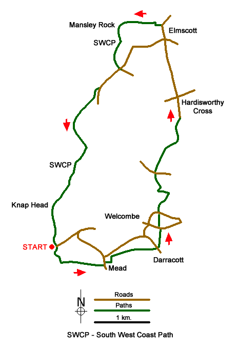
Knap Head to Mansley Cliff Walk
Author - Martyn Hanks
Length - 8.0 miles / 13 km
Ascent - 1600 feet / 485 metres
Grade - moderate
Start - OS grid reference SS213180
Lat 50.933691 + Long -4.544533
Postcode EX39 6HL (approx. location only)
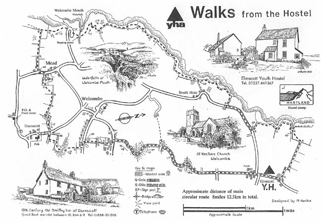
The North Devon Coast is well known for its high cliffs, which offer fine views and excellent walking. This walk starts from the small car park on the coast at Welcombe Mouth (grid ref. SS212179) and after a short section south along the South West Coast Path, turns inland to Mead from where paths, tracks and country lanes are followed north to Elmscott. Here the route continues back to the start following the South West Coast Path.
Leave the car park and follow the South West Coast Path south (with the sea on your right). The path climbs steeply out of the valley. Nearing the top of the climb turn right onto the path signed to Mead at grid reference SS213177. Follow this path eastwards as it climbs across fields to reach a lane in Mead (grid ref. SS221176). Turn left along the lane to reach a cluster of houses. Turn right onto a signed footpath (grid ref. SS221177). This path leads across fields and later becomes a track which leads to a lane (grid ref. SS230180) just to the north of Darracott.
Cross the lane and take the track opposite signed 'Unsuitable for motor vehicles'. This is Well Lane. After 50 metres take the footpath on the left. This path descends to cross a stream via a footbridge and the climbs up to a lane (grid ref. SS230183). Turn left along the lane and almost immediately right onto a signed footpath. Follow this path which soon leads onto a driveway which leads to a lane. Turn left and then bear right down a lane signed 'Unsuitable for motor vehicles'. This lane twists and turns as it descends into a valley before climbing up to a 'crossroads' (grid ref. SS229192).
Go straight across and follow the lane north for a mile to reach Hardisworthy Cross (grid ref. SS233205). Continue straight ahead and continue walking to Elmscott. Continue straight through Elmscott ignoring lanes going left and right. Continue past the Youth Hostel on your left. When the lane beads sharp right (grid ref. SS231218), turn sharp left and follow the signed path along a track which leads to a footpath across a field to reach the South West Coast Path (grid ref. SS224218) at Mansley Cliff.
Turn south along the coast path (with the sea to your right). After half a mile to coast path reaches a lane at Sandhole Cross (grid ref. SS224210). Turn right along the lane (signed as the Coast Path). After 500 metres turn right over a stile following the Coast Path sign. The remainder of the walk follows the South West Coast Path back to the start passing over Embury Beacon to reach Knap Head. From here there is steep descent back to the car park used at the start of the walk.
This walk is one of many routes prepared by Martyn Hanks for Youth Hostellers. The routes were drawn in a 'Wainwright' style and provided annotated maps offering additional information for walkers. Prepared before the days of GPS they were an invaluable resource and Walking Britain is happy to ensure that these walks remain in the public domain.
Messaging & Social Media
Message Walking Britain and follow the latest news.

Mountain Weather
Stay safe on the mountains with detailed weather forecasts - for iOS devices or for Android devices.