Mawddach circular from Arthog near Fairbourne
Snowdonia/Eryri Walk
Nat Park - Snowdonia - Cadair Idris
County/Area - Gwynedd
Author - Peter Smyly
Length - 9.0 miles / 14.6 km Ascent - 1300 feet / 394 metres
Time - 5 hours 50 minutes Grade - moderate
Maps 

| Ordnance Survey Explorer OL23 | Sheet Map | 1:25k | BUY |
| Anquet OS Explorer OL23 | Digital Map | 1:25k | BUY |
| Ordnance Survey Landranger 125 | Sheet Map | 1:50k | BUY |
| Anquet OS Landranger 125 | Digital Map | 1:50k | BUY |
Walk Route Description
Click image to visit gallery of 6 images.
This is a circular Snowdonia (Eryri) walk that provides a variety of gradients, terrain and scenery including green woods with waterfalls, a stretch of open moorland, a few remote mountain lakes and a minor top with good all round views. The walk concludes with a stretch along a disused former railway line alongside an estuary.
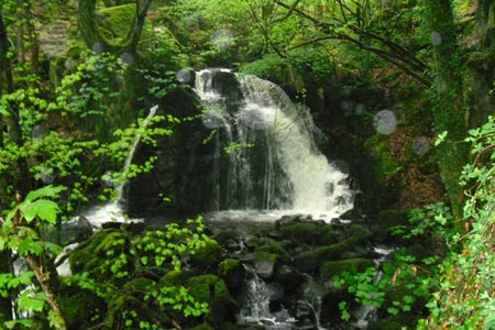
Start at the car park at Arthog and follow the path south east to the A493 main road where it is necessary to walk alongside the road for a while, taking care with any traffic. After passing the small church, St Catherine's Church, on the left, leave the road at a gate on the right. This gate marks the start of a path up through the Arthog Woods, steeply at first, via a series of stone steps. The path offers no difficulties from a route finding point of view and although the trees with green leaves and mosses and ferns dominate (depending on the time of year, of course), you are seldom far from the rushing water of a beck below to your left and from time to time there are pretty cascades and waterfalls to your left. A wooden stile over a dry stone wall marks the point where the path emerges partly into the open with woods still on your left. The path later emerges from the woods altogether and a clapper bridge over a stream appears on your left. There is a choice of routes from here to the Cregennen Lakes, the next objective, the way via the clapper bridge being one option. Another option is to follow the path ahead which leads to a narrow, secondary tarmac road. Follow this road to the left and, after a few hundred yards, a sign saying "Llynnau Cregennen" confirms you are going the right way.
Branch left where the road divides. Craig Las is the mountain on your right and Pared y Cefn Hir is the hill on your left. The two Cregennen Lakes appear over the brow of a hill, the larger one on the left being notable for its wooded island which gives the lake a picture postcard appeal, especially with Cader Idris as a backdrop. Follow the road down to the left, past the car park on the left and, when the road starts to lose height, leave the road to follow the footpath to the right which brings you to the shore of the larger of the two Cregennen Lakes. From the turn off from the road, there is a view down to the beach at Barmouth on the left with the Cregennen lakes on the right. Despite the ease of access by car to these lakes by way of a tarmac road, they still retain a remote, wild mountain feel about them and in no way do they resemble the tourist "honeypot" of Tarn Hows in the Lake District.
Pared y Cefn Hir is the hill that looms large on the left of the two lakes. Here the route offers you another choice. - a low level option by way of a footpath that leads you to Kings Youth Hostel or a relatively high level option over Pared y Cefn Hir and it is the latter that this route follows. Although of modest height, this is a fine viewpoint, especially looking back down on the Cregennen Lakes which appear to be much further below than they really are. A sheep path leads you through the heather on the top ridge and a couple of llyns also await you. First, windswept and remote Llyn Pen Moelyn, appears around the corner of a hill. About half a mile to the north east is another llyn which appears to see few visitors. Llyn Wylfa appears way below, but to reach it, involves finding your own way down as there is no path. The hill to the south of Llyn Wylfa offers a good view looking down on it with the Mawddach Estuary seen beyond the ridge on the far side of the lake. Llyn Wylfa is a shallow lake as indicated by reeds in the water and it has a couple of pancake-flat islands that look disproportionately large in relation to the body of water as a whole. Although it is less than a mile from Kings Youth Hostel, a lack of access paths means that the route between the two is not easy to follow. From the llyn, the best option is to locate the footpath coming from the Cregennen Lakes by heading roughly south east to meet the path coming from the Cregennen Lakes via Ty'n Llidiart.
The path down through woodland joins up with a tarmac road with Kings Youth Hostel appearing through trees at the foot of a wooded hill to the right. Follow the tarmac road downhill to cross the A493 road and the route continues on the other side towards Abergwynant and leads to the Mawddach Estuary where a left turn brings you on to the former railway line and part of the Mawddach Trail.
Other walks nearby
| Walk 1851 | Cregennen Lakes & Pared y Cefn-hir | easy/mod | 2.5 miles |
| Walk 1644 | Cregennen Lakes | moderate | 11.0 miles |
| Walk 1647 | Mawddach Bridge and Arthog | easy | 5.4 miles |
| Walk 1172 | Cadair Idris by the Pony Path | mod/hard | 11.0 miles |
| Walk 2668 | Cadair Idris, Craig Cau and Cyfrwy by the Pony Path | mod/hard | 5.3 miles |
| Walk 2570 | Cadair Idris from Llanfihangel-y-pennant | mod/hard | 10.0 miles |
| Walk 2707 | Tyrrau Mawr and Craig-y-llyn from Llanfihangel-y-pennant | moderate | 9.5 miles |
| Walk 1643 | Llanfihangel-y-pennant & Castell y Bere | easy/mod | 6.8 miles |
| Walk 3582 | Castell y Bere & Llanfihangel-y-pennant from Abergynolwyn | easy/mod | 5.7 miles |
| Walk 1309 | Tarren y Gesail | moderate | 8.0 miles |
Recommended Books & eBooks
Snowdonia: 30 Low-level and easy walks - South
 Guidebook describing 30 walks in Snowdonia, Wales. Routes are mostly low level and on clear paths and showcase the region's beautiful scenery and rich history and culture. Part of a 2-volume set, this southern volume includes Trawsfynydd, Bala, Dolgellau, Machynlleth, the Harlech Coast and the valleys of the Mawddach and Dyfi.
More information
Great Mountain Days in Snowdonia
 Inspirational guidebook to 40 great mountain day walks and scrambles in Snowdonia. Inspirational routes for all abilities across the National Park with routes up Snowdon and Moel Eilio, the Glyderau, the Carneddau, Eifionydd, Siabod and the Moelwynion, Rhinogydd (the Harlech Dome), Migneint and the Arans and Cadair Idris and the Tarrens.
More information
Messaging & Social Media
Message Walking Britain and follow the latest news.

Mountain Weather
Stay safe on the mountains with detailed weather forecasts - for iOS devices or for Android devices.