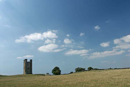
The Broadway Tower from Broadway
Cotswolds Walk
Region - Cotswolds
County/Area - Worcestershire
Author - Lou Johnson
Length - 5.0 miles / 8.1 km Ascent - 780 feet / 236 metres
Time - 3 hours 20 minutes Grade - easy/mod
Maps 

| Ordnance Survey Explorer OL45 | Sheet Map | 1:25k | BUY |
| Anquet OS Explorer OL45 | Digital Map | 1:25k | BUY |
| Ordnance Survey Landranger 150 | Sheet Map | 1:50k | BUY |
| Anquet OS Landranger 150 | Digital Map | 1:50k | BUY |
Walk Route Description
Click image to see photo description.
This walk combines the delights of the Worcestershire village of Broadway with the Broadway Tower perched high on the Cotswold Hills above the village. The village of Broadway contains many fine buildings made from the local stone and the High Street is particularly attractive with many shops, cafés and other amenities. Although this route is quite short, it does involve some climbing and you are forewarned that to obtain the superb views from near the Tower, you do have to expend some energy.
The start is the main pay and display car park in Broadway, which is located just off the Cheltenham Road (Grid ref. SP090377) with ample signage in place if approaching from the Evesham and Cheltenham directions. Exit the car park and make your way into the village. Continue along High Street admiring the many stone built buildings of character. Reaching the Horse & Hound Public House on the left, cross the road and take the signed footpath.
Continue along this path, keeping straight ahead and ignoring any other paths, to reach Snowshill Road (Grid ref. SP096365). Turn left along Snowshill Road and continue to the church at Broadway Court. Turn left here on the signed path to Broadway Tower, which leads you up Coneygree Lane. The steady climb continues for some way to reach a junction of paths (Grid ref. SP107361). Turn right here on a path that climbs less steeply. The path becomes a track and leads to a junction (Grid ref. SP107356). Turn left and follow the track uphill. Turn left into the Broadway Tower Country Park, where refreshments are available in season.
Continue northwards towards the Tower, which is located in a perfect location. One of England's outstanding viewpoints it is the second highest point on the Cotswold Hills. At 1024 feet (312m) above sea level, it is possible to survey an area which includes as many as thirteen counties. Built in 1799, it is a typical example of an 18th century Gothic folly. The views are superb and on a fine day include the Vale of Evesham, the Vale of Gloucester with the Severn Valley and the Welsh Mountains also included in the panorama. There is a charge for ascending the tower but this also includes admission to an exhibition.
Having enjoyed the view, the descent back to Broadway begins. From the north side of Broadway Tower join the Cotswold Way. This National Trail runs from Chipping Campden to Bath following the Cotswold Hills for much of the way. Like all National Trails, waymarking is generally good and by following the signs you descend quite steeply at first before levelling out when you reach the pastures behind Broadway village. Stay on the Cotswold Way at the first junction of paths and proceed to another junction, with the village in view to your right (Grid ref. SP103371). Turn right here, signed the Cotswold Way, and follow the path to reach High Street. Turn left and continue through the village to the car park where you began the walk.
Other walks nearby
| Walk 2094 | Snowshill Circular | easy | 4.4 miles |
| Walk 3063 | Stanway & Snowshill circular | moderate | 8.0 miles |
| Walk 1308 | Broadway & Chipping Campden | moderate | 11.0 miles |
| Walk 3327 | Temple Guiting & Cutsdean from Stanway | moderate | 10.0 miles |
| Walk 1749 | Upper Quinton & Hidcote Bartrim from Mickleton | easy/mod | 6.8 miles |
| Walk 2541 | Hidcote & Foxcote from Mickleton | easy/mod | 7.5 miles |
| Walk 3212 | Ebrington & Foxcote circular | easy | 3.7 miles |
| Walk 2495 | Bredon Hill Circular | moderate | 10.6 miles |
| Walk 2402 | Bredon Hill from Elmley Castle | easy/mod | 5.5 miles |
| Walk 3064 | Hailes, Beckbury & Sudeley from Winchcombe | moderate | 10.0 miles |
Recommended Books & eBooks
The Cotswold Way Map Booklet
 Map of the 102 mile (163km) Cotswold Way National Trail, between Chipping Camden and Bath. This booklet is included with the Cicerone guidebook to the trail, and shows the full route on OS 1:25,000 maps. The trail typically takes two weeks to walk, and is suitable for walkers at all levels of experience.
More information
The Cotswold Way
 Guidebook to walking the Cotswold Way National Trail. Between Chipping Campden and Bath, the 102 mile route explores the Cotswolds AONB. Described in both directions over 13 stages, the Cotswold Way can be walked year round and is suitable for beginner trekkers. Includes separate OS 1:25,000 map booklet of the route.
More information
Messaging & Social Media
Message Walking Britain and follow the latest news.

Mountain Weather
Stay safe on the mountains with detailed weather forecasts - for iOS devices or for Android devices.