Walk 3344 - printer friendly version
Holy Island & Lindisfarne Castle Circular Walk
Author - Lou Johnson
Length - 4.3 miles / 7 km
Ascent - 100 feet / 30 metres
Grade - easy
Start - OS grid reference NU125423
Lat 55.674040 + Long -1.8028151
Postcode TD15 2SX (approx. location only)
Holy Island, off the Northumberland coast, has many historic connections and sees many tourists. However once away from the village and Lindisfarne Castle you will enjoy some wild coastal scenery in relative solitude. Holy Island is cut off from the mainland at high tide so careful planning is required before starting this walk, which should take under three hours. Ideally you need to cross the causeway just as the road becomes passable on a falling tide. Safe crossing times are available from tourist information. Remember the road is closed for about seven hours between tides so do allow enough time to cross back to the mainland to avoid being stranded on the island.
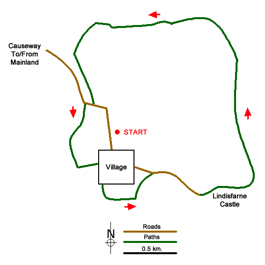
The start is the car park on the north side of the village (grid ref. NU125423). After parking walk into the village and continue to the parish church, which is adjacent to the ruined Priory. If you wish to the visit the latter then admission charges apply. Continue through the churchyard and exit via the gate to the west of the church. Once through the gate, turn left and follow the path across a rocky outcrop and down through the boatyard. Continue along a clear track that leads you along the harbour to reach a tarmac road. Follow this tarmac road towards Lindisfarne Castle.
Just prior to the castle the lane forks. Keep to the left here and pass the northern side of the castle. The tarmac soon ends and you should continue on the track to reach the eastern coast of the island. Here, head north walking parallel with a wall on your left and the coast to your right. Continue for about a kilometre to pass The Lough on your left (grid ref. NU137429). Soon after the path turns left (grid ref. NU135432) at a field boundary. The clear path heads west with dunes to your right and continues to a junction with a track (grid ref. NU129432). Do not turn left down the track but continue ahead on the path. Which soon loops left and takes you to the causeway road (grid ref. NU124425). Turn right along the road and take the first path on your left. This path follows the shoreline back to the centre of the village.
Messaging & Social Media
Message Walking Britain and follow the latest news.

Mountain Weather
Stay safe on the mountains with detailed weather forecasts - for iOS devices or for Android devices.