Farnhill Moor from Kildwick
North Yorkshire Walk
County/Area - North Yorkshire - Skipton
Author - Dave Melling
Length - 4.5 miles / 7.3 km Ascent - 800 feet / 242 metres
Time - 3 hours 0 minutes Grade - easy/mod
Maps 

| Ordnance Survey Explorer OL21 | Sheet Map | 1:25k | BUY |
| Anquet OS Explorer OL21 | Digital Map | 1:25k | BUY |
| Ordnance Survey Landranger 104 | Sheet Map | 1:50k | BUY |
| Anquet OS Landranger 104 | Digital Map | 1:50k | BUY |
Walk Route Description
Click image to visit gallery of 4 images.
This walk visits a medieval church, a Victorian monument on heather clad moor, two ancient burial mounds and a peaceful stretch of the Leeds - Liverpool Canal. There is a short steep section as the path descends from the moor. St Andrews Church is worth a closer look. Built in the 14th Century it contains not only monuments to both a local knight and a crusader but also pieces of pre Norman crosses.
The walk starts from the church of St Andrew, Kildwick (Grid reference SE 011459). Cars can be parked on the closed off road opposite the church. Outside the church there is a 1658 sundial and the remains of the public stocks. Take the road up the left hand side of the church and then right past the old school house. Cross the bridge over the Leeds Liverpool canal. Follow the paved path to the left of the gate to the cemetery. At the end of the path is a road. (A short diversion to the right gives a view of Kildwick Hall, a magnificent 17th century manor house guarded by white lions.) Turn left and walk along the road to a path on the right that leads onto the edge of the moor. Follow one of the tracks to the farm at Crag Top. Go through the gate on the left hand side onto Farnhill Moor.
There are many paths across the moor. The one with best views follows the edge of the redundant quarry. Head for the Jubilee tower on the skyline (SE 007472). This white painted monument cannot be missed. On the top is a stone carved cross with a rose, shamrock, thistle motif and the initials VR. These initials are the clue to the purpose of the monument. It was built in 1887 to celebrate the Golden Jubilee of Queen Victoria. Close by are carved stones that explain its erection and the restorations of 1935 and 2000 and other old graffiti stones. The view from here across Airedale is quite staggering.
Take the narrow path to the west of the monument that leads to a large cairn. Carry on to a junction in the path, turn left and head for the wall at Tewitt Mire. Turn left and follow the wall. This part of the moor is good for birds with moorland, trees and grazed fields in close proximity. Look out for grouse and the elusive short-eared owls. These owls feed during the day and are present during spring and summer in this type habitat. In the autumn, they move to the coastal estuaries.
Follow the path along the wall to a seat at Black Hill. Stop here and peer over the wall. The mound of stones in front of you is the Bronze Age (around 2000- 700 BC) Black Hill cairn, a funeral monument. To the right is another pile of millstone grit boulders almost 70m long forming a Neolithic long barrow, yet another funeral monument this time dating from 3400 - 2400 BC.
Follow the path round to the Jubilee tower. Find the path past the 1935 stone inscription and follow it as it descends northwards through the wood. Keep to the main path until a road is reached by Wood Cottage. Turn right and follow the road for a quarter of a mile, just past Hamblethorpe Farm. Take the stile on the left and follow the bridleway down the field to a gate. Continue down the side of next field and cross the swing bridge over the Leeds - Liverpool Canal.
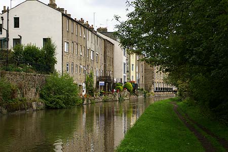
Turn left and follow the canal. Look out for Farnhill Hall on the left at a loop in the canal. A rare example of a 14th century fortified stone manor house. At the bridge marked 186 go through the kissing gate on the right hand side and make your way back into Kildwick.
Other walks nearby
| Walk 2904 | Cross Hills to Skipton via Low Bradley | easy/mod | 6.5 miles |
| Walk 2657 | Bradleys Both, near Skipton | easy/mod | 5.5 miles |
| Walk 3215 | Steeton to Ilkley without a car | moderate | 7.5 miles |
| Walk 3079 | Silsden Reservoir circular | easy | 6.0 miles |
| Walk 2942 | Below Silsden Moor | easy/mod | 6.8 miles |
| Walk 1793 | Lothersdale | easy/mod | 6.0 miles |
| Walk 2661 | Keighley Moor Reservoir & Hitching Stone from Cowling | moderate | 9.5 miles |
| Walk 2861 | Pinhaw Beacon from Lothersdale | easy | 4.0 miles |
| Walk 1811 | Sharp Haw in Airedale | easy/mod | 7.0 miles |
| Walk 1905 | Beamsley Beacon and Bolton Abbey | moderate | 10.0 miles |
Recommended Books & eBooks
Trail and Fell Running in the Yorkshire Dales
 Guidebook to 40 of the best trail and fell runs in the Yorkshire Dales National Park. Ranging from 5 to 24 miles, the graded runs start from bases such as Ribblehead, Dent, Sedbergh, Malham and Grassington and take in the region's diverse delights, from castles and waterfalls to iconic mountains such as Whernside, Ingleborough and Pen Y Ghent.
More information
Messaging & Social Media
Message Walking Britain and follow the latest news.

Mountain Weather
Stay safe on the mountains with detailed weather forecasts - for iOS devices or for Android devices.