Beeson to Salcombe
Devon Walk
County/Area - Devon
Author - Andy Smith & Tony Maries
Length - 12.0 miles / 19.5 km Ascent - 3300 feet / 1000 metres
Time - 9 hours 20 minutes Grade - mod/hard
Maps 

| Ordnance Survey Explorer OL20 | Sheet Map | 1:25k | BUY |
| Anquet OS Explorer OL20 | Digital Map | 1:25k | BUY |
| Ordnance Survey Landranger 202 | Sheet Map | 1:50k | BUY |
| Anquet OS Landranger 202 | Digital Map | 1:50k | BUY |
Walk Route Description
Click image to visit gallery of 3 images.
South Devon offers some of the finest coastline on mainland Britain, ranging from golden sandy beaches to dramatic rocky cliffs plunging into the sea. Although this route is spread over two days, the going is relatively easy as this section of the South West Coast Path is well walked and the way ahead clear. The walk takes in the lovely seaside resort of Salcombe as the half waypoint, with its stunning cliff top approach from the east.
Day One - The walk starts from the small village of Beeson (Grid ref. SX811408), just south of Slapton Sands where there are a few street parking options. Walk out of the village on the tiny road leading down to Beesands beach; here pick up the South West Coast Path just above the beach heading southbound. Within the first half hour you reach the ruined village of Hallsands. On a dark January night in 1917 a hard storm took place and the beach in front quite literally disappeared into the sea, taking most of the homes in this tragic event. Even to this date it is not known whether dredging the shoreline was to blame, or simply speeded up the inevitable.
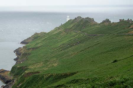
From there continue along the coast around Start Point, a short extension to the lighthouse is well worthwhile (grid ref. SX829371). After turning the corner, the coastline becomes a lot more dramatic with a strong history of many shipwrecks in this area; care should be exercised on this section at all times.
Passing the coastguard lookout at Prawle Point, make sure to notice the natural arch carved out the cliffs, not as spectacular as Durdle Door in nearby Dorset but still a sight worth looking out for. Continue along the Coast Path to pass Gammon Head and onto Gara Rock. From here the going is good and you can set a great pace reaching out for the town of Salcombe. The high-level cliff top entry into the estuary is quite stunning and somewhat tropical as you stare though the ferns down onto the golden sands 100 feet below packed with holidaymakers. The path winds inland into the east side of the town where the next objective lies - the ferry. This tiny 10-man boat is quite an experience as the sea can be somewhat choppy! Remember to bring some change for this, around £ 1.80 to cross.
Once across the estuary, there are many possibilities for accommodation including a choice of four campsites, the nearest and probably best kitted is Rew 1.5km to the west (Grid ref. SX714382).
Continue to Day Two Description
Other walks nearby
| Walk 3427 | Slapton Sands & Stokenham from Torcross | easy/mod | 8.0 miles |
| Walk 3346 | Start Point from Torcross | easy/mod | 8.0 miles |
| Walk 1857 | Start Point & East Prawle | moderate | 8.2 miles |
| Walk 1866 | East Prawle & Prawle Point | easy/mod | 4.1 miles |
| Walk 2474 | East Prawle Coast Circular | easy/mod | 5.6 miles |
| Walk 3432 | Salcombe to Thurlestone | mod/hard | 11.0 miles |
| Walk 2371 | Kingswear to Brixham | moderate | 10.8 miles |
| Walk 3587 | Kingswear from Coleton Fishacre | moderate | 7.0 miles |
| Walk 2461 | Warren Point & Bolt Tail from Bantham | moderate | 9.0 miles |
| Walk 3041 | Thurlestone circular | easy | 4.0 miles |
Recommended Books & eBooks
South West Coast Path Map Booklet - St Ives to Plymouth
 Map of part of the southern section of the 630 mile (1014km) South West Coast Path National Trail. Covers the trail from St Ives to Plymouth along the west Cornwall and Devon coastline. This convenient and compact booklet of Ordnance Survey 1:25,000 maps shows the route, providing all of the mapping you need to walk the trail in either direction.
More information
South West Coast Path Map Booklet - Minehead to St Ives
 Map of the northern section of the 630 mile (1014km) South West Coast Path National Trail. Covers the trail from Minehead to St Ives along the north Devon and Cornish coastline. This convenient and compact booklet of Ordnance Survey 1:25,000 maps shows the route, providing all of the mapping you need to walk the trail in either direction.
More information
Messaging & Social Media
Message Walking Britain and follow the latest news.

Mountain Weather
Stay safe on the mountains with detailed weather forecasts - for iOS devices or for Android devices.