Shining Tor, Cats Tor & Foxlow Edge from Errwood
Peak District Walk
Nat Park - Peak District - Goyt Valley Lyme Park
County/Area - Derbyshire & Cheshire
Author - Lou Johnson
Length - 7.0 miles / 11.4 km Ascent - 1350 feet / 409 metres
Time - 4 hours 50 minutes Grade - easy/mod
Maps 

| Ordnance Survey Explorer OL24 | Sheet Map | 1:25k | BUY |
| Anquet OS Explorer OL24 | Digital Map | 1:25k | BUY |
| Ordnance Survey Landranger 118 | Sheet Map | 1:50k | BUY |
| Anquet OS Landranger 118 | Digital Map | 1:50k | BUY |
Walk Route Description
Click image to visit gallery of 12 images.
The hills on the western side of the Goyt Valley mark the boundary Derbyshire/Cheshire border and also provide for some excellent walking. This route not only explores the main ridge between Shining Tor and Cats Tor but also traverses the length of the short but pleasant Foxlow Edge which lies between the main ridge and Errwood Reservoir.
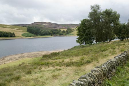
The start of this Peak District walk is the main car park at the western end of the dam across Errwood Reservoir (grid ref. SK013756). The car park further south along the reservoir (grid ref SK012748) is more convenient but cannot be accessed at weekends and bank holidays during the summer. Also note that the public conveniences in the area are all closed as of August 2009 and look unlikely to reopen in the near future. After parking, walk south with the reservoir on your left. Cross Shooter's Clough Bridge (grid ref. SK011749) and pass the alternative car park on your right. Just pass the car park look out for a finger post on the right to Stake Farm and the Cat and Fiddle. Take this path.
The path climbs easily through a section of woodland before entering open hill side. The way ahead is never in doubt and you soon start to get good views across Errwood Reservoir and the surrounding hills. The path continues alongside a wall, passes a path junction that leads down to Errwood Hall and makes progress towards another path junction high on the moor (grid ref. SK001731). Turn right here towards Shining Tor. The summit is soon reached and if you clamber over the wall you will be in Cheshire. The view is good especially south with Shutlingsloe (the Cheshire Matterhorn) prominent in the landscape.
The walk continues north along the main ridge path keeping the wall on your left. The path has seen plenty of reconstruction work in recent years and the continuous bog of former years is now a well made path that allows you to continue to the summit of Cat's Tor with dry feet. Dropping down on the north side of Cat's Tor the view ahead along the ridge includes Windgather Rocks, which are usually easy to pick out.
Reaching a road, bear right and follow the road downhill towards the Goyt Valley. There is a path on the left side of the road which avoids confrontations with traffic. Stay on this path until you reach a small parking area with a finger post on the right hand side of the road (grid ref. SK002761). Follow this sign to Errwood Hall and Foxlow Edge. After a short way the path forks. Bear left and start to ascend gently onto Foxlow Edge. The views to your right of the first part of the walk are excellent and you also get glimpses of Errwood Reservoir on your left. Continue on the main path along the ridge ignoring any paths that go left or right.
The path starts to lose height and should be followed downhill to reach a wider path coming in from your right. Bear slightly left and follow this wider path down to the road. Turn left if you have parked at the main car park or right if you have used the alternative car park.
Other walks nearby
| Walk 1092 | Taxal Edge, Jenkin Chapel & Pym Chair | moderate | 8.5 miles |
| Walk 1233 | Shining Tor & Windgather Rocks | moderate | 7.5 miles |
| Walk 2527 | Kettleshulme & Taxal Edge from Lamaload | moderate | 10.0 miles |
| Walk 1183 | Shining Tor & Axe Edge Moor | moderate | 9.0 miles |
| Walk 1728 | Axe Edge Moor & Three Shires Head | easy/mod | 7.2 miles |
| Walk 3136 | Shining Tor & Goyt's Clough | easy/mod | 5.1 miles |
| Walk 2635 | The edges of Combs Moss near Chapel-en-le-Frith | easy/mod | 7.5 miles |
| Walk 1652 | Three Shires Head | easy | 4.5 miles |
| Walk 2233 | Flash & Three Shires Head | easy/mod | 6.2 miles |
| Walk 2272 | Flash Circular from Cistern Clough | moderate | 8.0 miles |
Recommended Books & eBooks
Walking in the Peak District - White Peak East
 Guidebook describing 42 half-day and day walks in the limestone landscapes of Derbyshire's White Peak, part of the Peak District National Park. One of two volumes, this book covers the east of the region, with potential bases including Bakewell, Eyam, Castleton, Birchover, Matlock and Wirksworth.
More information
Dark Peak Walks
 Guidebook to 40 walks in the Dark Peak area of the Peak District National Park. 35 circular routes for most abilities, from 8km to 19km, around Edale, Marsden, Fairholmes, Baslow and Castleton, including Kinder Scout and Mam Tor, and 5 longer (25km to 45km) routes highlighting the best of the Gritstone Edges, High Moorland and Deep Valleys.
More information
Messaging & Social Media
Message Walking Britain and follow the latest news.

Mountain Weather
Stay safe on the mountains with detailed weather forecasts - for iOS devices or for Android devices.