High Sweden Bridge from Ambleside
Lake District Walk
Nat Park - Lake District - Lake District Eastern Fells
County/Area - Cumbria
Author - Peter Smyly
Length - 3.0 miles / 4.9 km Ascent - 700 feet / 212 metres
Time - 2 hours 10 minutes Grade - easy/mod
Maps 

| Ordnance Survey Explorer OL5 | Sheet Map | 1:25k | BUY |
| Anquet OS Explorer OL5 | Digital Map | 1:25k | BUY |
| Ordnance Survey Landranger 90 | Sheet Map | 1:50k | BUY |
| Anquet OS Landranger 90 | Digital Map | 1:50k | BUY |
Walk Route Description
Click image to visit gallery of 6 images.
Although the name is not Scandinavian in origin, High Sweden Bridge is a packhorse bridge, a mile up the Scandale Valley from Ambleside. The bridge enables a lovely Lake District circular walk to be made, by crossing Scandale Beck and returning down the other side of the valley via Low Sweden Bridge. Or, for walkers with more time for a walk, it represents the first stretch in an anti-clockwise round of the Fairfield Horseshoe.
The route offers no difficulties from a route-finding perspective. Sturdy footwear is advisable since the trail is rocky in places and liable to be wet where side streams enter the main bridleway going up to High Sweden Bridge. The only notably steep stretch is when you leave High Sweden Bridge and head up a well constructed path on the other side to gain the path going back down to Ambleside.
One possible start point is the car park off Rydal Road in Ambleside, then crossing Rydal Road to walk up Smithy Brow which joins the Kirkstone Road coming downhill from the left. Take the first left turning for Sweden Bridge Lane. Follow the tarmac road all the way up the hill, passing Ellerigg Road on the right before the road ahead shortly becomes an unsurfaced bridleway leading through a gate away from houses and with fields either side beyond dry stone walls. The route winds its way up with views of Wansfell Pike to the right. To the left there is a view looking down on the village of Ambleside with Loughrigg immediately behind and Rydal Water to its right. Further away you can see, from left to right, the mountains of Crinkle Crags, Bowfell, the Langdale Pikes and Sergeant Man. It is also possible to see, further up the lane, part of the return route down the other side of the valley with the Fairfield Horseshoe as a backdrop.
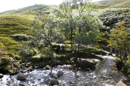
After passing a barn on the right, the track goes downhill for a short distance to enter deciduous woodland and the rushing waters of Scandale Beck can be seen and heard some distance below to the left. Eventually the track and the beck become much closer as High Sweden Bridge appears round a corner, still another hundred yards or so distant. There are some fine cascades on the beck here if you look over the edge from near the path, though care should be taken.
The bridge is a fine example of a packhorse bridge and is believed to be centuries old. Looking up the Scandale valley, Red Screes is the mountain to the right while High Pike and Low Pike appear on the left, part of the Fairfield Horseshoe.
Now cross the bridge and follow the constructed stone path up the other side of the fellside, crossing a wooden stile on the way. The path then follows down the shoulder of the fell on the other side of Scandale Beck with a fine view ahead overlooking the village of Ambleside with Windermere (lake) beyond, backed by Latterbarrow, the highest point on Claife Heights. The track descends to cross the river at Low Sweden Bridge where there are some cascades and then, passes through a gate, leading to Low Nook Farm. Following the tarmac secondary road, the Charlotte Mason Library is passed on the right along with some cottages. At the next fork, turn left on to Belle Vue Lane which in turn leads you back to Sweden Bridge Lane and the Kirkstone Road. Or alternatively continue straight on down Nook Lane to return to the village and the start point.
Other walks nearby
| Walk 2026 | Loughrigg from Pelter Bridge near Rydal | easy/mod | 4.0 miles |
| Walk 3034 | Red Screes & Other Fells from Ambleside | mod/hard | 10.0 miles |
| Walk 3697 | Loughrigg Fell from Skelwith Bridge | easy/mod | 4.5 miles |
| Walk 1823 | Fairfield Horseshoe & Loughrigg from High Close | mod/hard | 14.0 miles |
| Walk 1472 | Alcock Tarn & Rydal Water | easy/mod | 7.0 miles |
| Walk 1565 | Rydal Water & Grasmere circular | easy/mod | 6.0 miles |
| Walk 1682 | Rydal Water & Grasmere | easy/mod | 5.5 miles |
| Walk 2715 | Skelwith Bridge & Loughrigg | easy/mod | 5.5 miles |
| Walk 1684 | Lingmoor Fell & Langdale | easy/mod | 7.0 miles |
| Walk 1141 | Elterwater circular | easy/mod | 4.0 miles |
Recommended Books & eBooks
Walking the Lake District Fells - Langdale
 Part of the Walking the Lake District Fells series, this guidebook covers a wide range of routes to 25 Lakeland summits that can be climbed from the Great Langdale valley, Ambleside and Grasmere, with highlights including Scafell Pike, Bowfell, the Langdale Pikes and Helm Crag (the Lion and the Lamb). Includes suggestions for longer ridge routes.
More information
Outdoor Adventures with Children - Lake District
 Guidebook to 40 outdoor adventures in the Lake District with children under 12, including walking, cycling, orienteering, paddling, boating, hostelling and more. Graded activities for varying age ranges or for families with children of different ages.
More information
Messaging & Social Media
Message Walking Britain and follow the latest news.

Mountain Weather
Stay safe on the mountains with detailed weather forecasts - for iOS devices or for Android devices.