Pilsbury Castle from Hartington
Peak District Walk
Nat Park - Peak District - Dove Valley Chrome Hill
County/Area - Derbyshire & Staffordshire
Author - Lou Johnson
Length - 5.5 miles / 8.9 km Ascent - 600 feet / 182 metres
Time - 3 hours 20 minutes Grade - easy/mod
Maps 

| Ordnance Survey Explorer OL24 | Sheet Map | 1:25k | BUY |
| Anquet OS Explorer OL24 | Digital Map | 1:25k | BUY |
| Ordnance Survey Landranger 119 | Sheet Map | 1:50k | BUY |
| Anquet OS Landranger 119 | Digital Map | 1:50k | BUY |
Walk Route Description
Click image to visit gallery of 3 images.
The village of Hartington is a popular place for visitors with its many cafes, pubs, shops and cheese factory. Its proximity to the River Dove and the most dramatic portion of Dovedale give the village extra importance in the eyes of many walkers and the paths south from the village can be very busy on fine days as everyone heads for Beresford Dale.
This Peak District walk starts from the pond located in the centre of the village (grid ref. SK 128605). Parking can be hard to find on busy days but usually on-street spaces are available. From the pond head north up Dig Street. Just after this road bends right, fork right up the green Wallpit lane to join Hide Lane. Turn left and continue north on this road to reach a signed footpath on your left (grid ref. SK 130613). The onward route from here is straightforward crossing fields as you traverse the flanks of Carder Low. On this section there is a small limestone pavement, which is a rarity in the Peak District. Passing the remains of former mine workings you descend into a side valley to reach a junction of paths (grid ref. SK 124634) where you turn left.
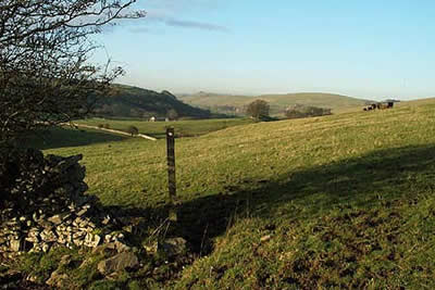
Reaching a road, cross straight over and continue on the waymarked path to reach the remains of Pilsbury Castle. This Norman motte and bailey earthwork is in a pleasant position with an excellent view north along the River Dove to Chrome and Parkhouse Hills. If you are in need of refreshment then about a mile and a half north on well-marked footpath is the village of Crowdecote where the Packhorse Inn offers a warm welcome. If you take this option then you need to retrace your steps back to Pilsbury before continuing with the remainder of the walk.
From the Castle head south along the farm track to the road and continue down through the hamlet of Pilsbury. Turn right to reach the footbridge over the River Dove (grid ref. SK 115634) and cross from Derbyshire into Staffordshire. A green lane is followed for about 150 metres before crossing the first stile on your left. The onward path climbs quite steeply across pastures to reach a minor road near the mock castle on Sheen Hill. Turn left along the lane to reach Harris Close Farm where a well-marked path leaves the lane to cross a number of fields before descending along the edge of a small conifer plantation to a gate and stile. Cross this stile and follow the path over the Dove to reach the Hartington Cheese factory. Turn left along the road to return to the start of the walk.
Other walks nearby
| Walk 1369 | Tissington Trail - Hartington to Parsley Hey | easy | 4.0 miles |
| Walk 2455 | Lum Edge & Revidge Moor | easy/mod | 6.5 miles |
| Walk 1021 | Milldale & Hall Dale | easy/mod | 5.0 miles |
| Walk 1257 | Wolfscote Dale | easy/mod | 7.5 miles |
| Walk 1709 | Milldale and Wolfscote Dale | easy/mod | 6.5 miles |
| Walk 3597 | Manifold Valley, Thor's Cave, Ecton & Wetton Hills from Alstonefield | moderate | 10.0 miles |
| Walk 3601 | Dove & Manifold Valleys | moderate | 10.0 miles |
| Walk 3709 | Sparklow, Crowdicote & Pilsbury Circular | easy/mod | 9.0 miles |
| Walk 1181 | Wetton Hill & the Manifold Valley | easy/mod | 6.5 miles |
| Walk 1653 | The Manifold Valley from Wetton | easy/mod | 7.8 miles |
Recommended Books & eBooks
Walking in the Peak District - White Peak East
 Guidebook describing 42 half-day and day walks in the limestone landscapes of Derbyshire's White Peak, part of the Peak District National Park. One of two volumes, this book covers the east of the region, with potential bases including Bakewell, Eyam, Castleton, Birchover, Matlock and Wirksworth.
More information
Walking in Derbyshire
 Walking guidebook to 60 circular day walks in Derbyshire and the Peak District. Includes the Derwent, Wye and Trent river valleys, near Derby, Matlock, Glossop, Bakewell and Ripley. Routes range from easy to moderate and are between 4 and 14km (2 to 10 miles). Walks focus on places of interest, from Stone Age forts to castles to grand estates.
More information
Messaging & Social Media
Message Walking Britain and follow the latest news.

Mountain Weather
Stay safe on the mountains with detailed weather forecasts - for iOS devices or for Android devices.