Post Gwyn and Craig-y-Mwn from Pistyll Rhaeadr
Powys Walk
County/Area - Powys - Powys North
Author - Lou Johnson
Length - 6.5 miles / 10.6 km Ascent - 1255 feet / 380 metres
Time - 4 hours 30 minutes Grade - moderate
Maps 

| Ordnance Survey Explorer 255 | Sheet Map | 1:25k | BUY |
| Anquet OS Explorer 255 | Digital Map | 1:25k | BUY |
| Ordnance Survey Landranger 125 | Sheet Map | 1:50k | BUY |
| Anquet OS Landranger 125 | Digital Map | 1:50k | BUY |
Walk Route Description
Click image to visit gallery of 2 images.
The Berwyn Mountains are often criticised for being boring. However there are plenty of good walks and with few people around to spoil your day you can just get on an enjoy the hills. This walk starts from the popular beauty spot of Pistyll Rhaeadr a few miles west of Llanrhaeadr-ym-Mochant. Parking is available on the roadside and there is also a car park and cafe where a fee is payable (grid ref. SJ 073295). Some skill at map reading is required as part of this walk covers open country and your best bet is to obtain a copy of the relevant 1:25000 OS map.
The waterfalls, the biggest in Wales, are the only attraction for most visitors and they are indeed quite spectacular especially after heavy rain with the waters dropping over two hundred feet. The best view of the falls is kept to the end of the walk and you start by ascending a signed zigzag path that climbs to the head of the falls. This leads onto a wide grassy path heading west along the northern banks of the Afon Disgynfa.
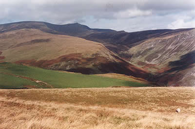
The path begins to fade and you may need to swap from bank to bank as the stream narrows. After about two miles from the head of the falls (grid ref. SJ 040302) turn south seeking an easy line following sheep trods through the heather onto the ridge. This should bring you onto the ridge about 700 metres north-west of the summit cairn of Post Gwyn. Continue south-east to the summit which has a few rocks and offers a good view especially to Cadair berwyn in the north and across the hills south and west.
A feint path continues south east along the ridge skirting the southern edge of a conifer plantation. You cross two fences to reach a footpath (grid ref. SJ 067284). Go through the gate and with the fence to your right continue south east to meet a track. Turn left onto this former mine track and head north. This will bring you to the top of the cliffs - Craig y Mwn - from where there is a super view down to the Tanat Valley below with the highest peaks of the Berwyns adding a good backdrop.
Locate a small gate on your right (grid ref. SJ 073290) and follow the path that descends spectacularly across the face of the cliffs. Note - in icy weather this could be treacherous. The path joins a mine track at the bottom. Turn left and follow the zigzags down to pick up a clear path heading north-west alongside a small stream. This leads along the base of the crags and through woodland to Pistyll Rhaeadr and the start of the walk.
Other walks nearby
| Walk 3031 | Cadair Berwyn | moderate | 9.3 miles |
| Walk 1256 | Cadair Bronwen | moderate | 9.5 miles |
| Walk 1989 | Llanarmon Dyffryn Ceiriog Circular | moderate | 6.0 miles |
| Walk 3102 | Bwlch Sych and Tynygarreg from Lake Vyrnwy | moderate | 8.5 miles |
| Walk 2055 | Moel Emoel from near Bala | moderate | 6.0 miles |
| Walk 3655 | Rhewl, Moel y Gamelin & Moel Morfydd | moderate | 5.4 miles |
| Walk 1845 | Castell Dinas Bran from Llangollen | easy/mod | 4.0 miles |
| Walk 3017 | Aran Benllyn & Aran Fawddwy from Llanuwchllyn | mod/hard | 10.0 miles |
| Walk 1067 | Ruabon Mountain & The Limestone Edges of Llangollen | moderate | 11.0 miles |
| Walk 2059 | Castell Carndochan near Bala | easy/mod | 2.5 miles |
Recommended Books & eBooks
The Cambrian Way
 Guidebook to the Cambrian Way, a challenging three-week mountain trek through Wales from Cardiff to Conwy. The 470km un-waymarked route is presented from south to north. Often sticking to long, beautiful ridgelines, it crosses wild and rugged terrain and visits many of Wales's highest mountains, including Snowdon.
More information
Messaging & Social Media
Message Walking Britain and follow the latest news.

Mountain Weather
Stay safe on the mountains with detailed weather forecasts - for iOS devices or for Android devices.