Mam Tor & Cave Dale from Castleton
Peak District Walk
Nat Park - Peak District - Great Ridge Castleton
County/Area - Derbyshire
Author - Lou Johnson
Length - 6.5 miles / 10.6 km Ascent - 1320 feet / 400 metres
Time - 4 hours 30 minutes Grade - moderate
Maps 

| Ordnance Survey Explorer OL1 | Sheet Map | 1:25k | BUY |
| Anquet OS Explorer OL1 | Digital Map | 1:25k | BUY |
| Ordnance Survey Landranger 110 | Sheet Map | 1:50k | BUY |
| Anquet OS Landranger 110 | Digital Map | 1:50k | BUY |
Walk Route Description
Click image to visit gallery of 2 images.
Interesting walks containing both the White and Dark Peaks are limited to the areas where the Limestone and Gritstone meet. The following Peak District walk covers an area that has much to offer the walker including those of a less adventurous disposition. It is an ideal introduction for those making their first visit to the Peak District offering a taste of the two essential ingredients of the National Park.
The village of Castleton lies on the northern edge of the White Peak. With a good selection of pubs, cafes and shops it is a popular day trip destination from the surrounding towns and cities. In addition there are the "show" caves which also help attract visitors so an off peak period may be best time to make this walk.
There is a large public car park (grid ref. SK 148829) in Castleton and after paying your dues, follow the main road in the direction of Hope. Where the main road turns sharp right continue north along Hollowford Road which leads gently upwards towards the Castleton ridge ahead. Reaching open country the path steepens. This is the only section of "hard work" and soon you have reached the top of the ridge at Hollins Cross.
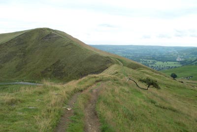
The ridge, which links Lose Hill with Mam Tor, is a popular place to promenade. The well-maintained path is easy going and offers excellent views south over the White Peak and to Edale and the Kinder Plateau in the north. With most of the climbing over, continue west along the ridge to the summit of Mam Tor. Notice the huge landslides here and at other places along the ridge. The most recent of these was of such magnitude that it severed the main A625 Castleton to Chapel-en-le-Frith road, which is still closed to traffic.
Dropping down to the col at Mam Nick head down the path on your left which crosses fields and heads up towards the long abandoned spoil tips of Slitherstone Mine. You are now in the White Peak. At the major junction of paths turn east to reach the Limestone Way just short of Hazard Mine. Turning north follow the path down Cave Dale passing the remains of Peveril Castle high on your left to reach the village of Castleton and the end of the walk.
It is possible to shorten the walk by descending Winnats Gorge - a wonderful section of limestone scenery. If you opt to take this route you can reduce road walking by looking for the path which leaves the road on the right shortly after passing the entrance to Speedwell Cavern. This takes you across the fields to reach Castleton near to the entrance to Peak Cavern.
Other walks nearby
| Walk 1688 | Old Dam & Sparrowpit from Mam Nick | moderate | 9.0 miles |
| Walk 1286 | Castleton Great Ridge & Mam Tor | moderate | 8.5 miles |
| Walk 2599 | Kinder Scout and Castleton Ridge from Hope | mod/hard | 13.5 miles |
| Walk 1706 | Win Hill from Hope | easy/mod | 6.5 miles |
| Walk 2522 | Rushup Edge & Edale from Mam Nick | moderate | 7.0 miles |
| Walk 1368 | Mam Tor, Upper Booth & Rushup Edge | moderate | 7.0 miles |
| Walk 1831 | Mam Tor & Hollins Cross from Mam Nick | easy | 3.0 miles |
| Walk 1080 | Shatton Moor and Offerton | easy/mod | 7.5 miles |
| Walk 1159 | Grindsbrook & Edale Head | moderate | 7.5 miles |
| Walk 1264 | Rushup Edge & Crowden Tower | moderate | 10.0 miles |
Recommended Books & eBooks
Great Mountain Days in the Pennines
 An inspirational guidebook to 50 classic walks on the rolling Pennine landscape. The graded routes, between 6 and 13 miles in length, cover classic Pennine fells and moorland such as Whernside, Ilkley Moor and Pendle Hill; exploring the North and South Pennines, Yorkshire Dales, Howgills and Dark Peak. Many routes are also suited to fell running.
More information
Dark Peak Walks
 Guidebook to 40 walks in the Dark Peak area of the Peak District National Park. 35 circular routes for most abilities, from 8km to 19km, around Edale, Marsden, Fairholmes, Baslow and Castleton, including Kinder Scout and Mam Tor, and 5 longer (25km to 45km) routes highlighting the best of the Gritstone Edges, High Moorland and Deep Valleys.
More information
Messaging & Social Media
Message Walking Britain and follow the latest news.

Mountain Weather
Stay safe on the mountains with detailed weather forecasts - for iOS devices or for Android devices.