Higger Tor & Burbage Rocks from Longshaw
Peak District Walk
Nat Park - Peak District - Gritstone Edges Higger Tor
County/Area - Derbyshire
Author - Lou Johnson
Length - 5.3 miles / 8.6 km Ascent - 600 feet / 182 metres
Time - 3 hours 20 minutes Grade - easy/mod
Maps 

| Ordnance Survey Explorer OL1 | Sheet Map | 1:25k | BUY |
| Anquet OS Explorer OL1 | Digital Map | 1:25k | BUY |
| Ordnance Survey Landranger 110 | Sheet Map | 1:50k | BUY |
| Anquet OS Landranger 110 | Digital Map | 1:50k | BUY |
Walk Route Description
Click image to visit gallery of 9 images.
This short half day Peak District walk is a route full of contrasts. In the early stages the walk crosses some wild moorland and includes the well known rocky viewpoint of Higger Tor. From here the views across the valley to the gritstone Burbage Edge are excellent. The return route follows the infant Burbage Brook which includes a delightful section towards the end of the walk. Finally you have a chance to explore some of the grounds of the National Trust's Longshaw Estate. Refreshments are available at the start and end in Longshaw Lodge.
The start is the main National Trust car park for the Longshaw Estate (grid ref. SK266800). After parking follow the signed footpath towards Longshaw Lodge. On reaching the main drive turn right and walk to the B6521. Cross this road carefully and bear right to take a signed footpath on your left (grid ref. SK265802). Follow this clear path through light woodland until you reach the busy A6187 at Burbage Bridge. Cross when safe and follow the road to the left. Once across the bridge take the first footpath on the right.
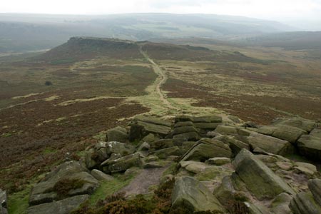
The onward route crosses Hathersage Moor. It can be a little wet underfoot after rain. The path is distinct and well trodden trending roughly northwards to Carl Wark an ancient fort which rises above the surrounding moorland. Descend a little and keep on the same bearing towards Higger Tor which is the next objective. This gritstone mass rises quite sharply although the ascent is relatively short lived. Once you have gained the top it is worth spending a few minutes exploring as there are some fine views to be enjoyed in all directions.
Continue in the same direction leaving Higger Tor. Bear right at the first major junction of paths to walk parallel to the road on your left. This road is rather quaintly known as Fiddler's Elbow probably because of its alignment. On reaching the road (grid ref. SK260829) bear right and cross Upper Burbage Bridge. From here you have a lovely view of your return walk.
Once across Upper Burbage Bridge turn right and follow the broad path along the east side of the valley. To your left are Burbage Rocks a favourite spot for climbers. This is easy walking and you will get a fine view of Higger Tor on your right as you gently descend. You reach the A6187 just east of Burbage Bridge (grid ref. SK262805). Cross this busy main road and take the footpath opposite. After a short way you reach the path used in the early stages of the walk. You can turn left and return easily to the start but a much more enjoyable finale to the walk is to bear right and walk towards Burbage Bridge.
Before you reach the road turn left (grid ref. SK261806), cross the footbridge over Burbage Brook and follow the path down the stream. This is a pretty stretch and in fine weather is a popular place to relax and perhaps paddle in the brook. Continue down to the next footbridge (grid ref. SK257800). Cross this bridge and walk up to the B6521. Cross the road and bear right to take a signed footpath on the left. This leads up Granby Wood, passes a small lake and leads to Longshaw Lodge and back to the start.
Other walks nearby
| Walk 1273 | Burbage Rocks & Padley Gorge from Hay Wood | moderate | 11.0 miles |
| Walk 2515 | The River Derwent, Curbar, Baslow & Froggatt Edges | easy/mod | 7.5 miles |
| Walk 2520 | Higger Tor & the Longshaw Estate | moderate | 9.0 miles |
| Walk 1479 | Burbage Moor & Redmires from near Ringinglow | easy/mod | 9.8 miles |
| Walk 2548 | Stanage Edge from Hathersage | moderate | 8.5 miles |
| Walk 1169 | Baslow Edge & Wellington's Monument | easy | 3.5 miles |
| Walk 1240 | Curbar, Froggatt & White Edges | easy/mod | 8.0 miles |
| Walk 1090 | Stanage Edge | moderate | 7.0 miles |
| Walk 1541 | Redmire, Stanage & Ughill Moor circular | moderate | 13.0 miles |
| Walk 1580 | Redmires Reservoir | easy | 2.5 miles |
Recommended Books & eBooks
Dark Peak Walks
 Guidebook to 40 walks in the Dark Peak area of the Peak District National Park. 35 circular routes for most abilities, from 8km to 19km, around Edale, Marsden, Fairholmes, Baslow and Castleton, including Kinder Scout and Mam Tor, and 5 longer (25km to 45km) routes highlighting the best of the Gritstone Edges, High Moorland and Deep Valleys.
More information
Great Mountain Days in the Pennines
 An inspirational guidebook to 50 classic walks on the rolling Pennine landscape. The graded routes, between 6 and 13 miles in length, cover classic Pennine fells and moorland such as Whernside, Ilkley Moor and Pendle Hill; exploring the North and South Pennines, Yorkshire Dales, Howgills and Dark Peak. Many routes are also suited to fell running.
More information
Messaging & Social Media
Message Walking Britain and follow the latest news.

Mountain Weather
Stay safe on the mountains with detailed weather forecasts - for iOS devices or for Android devices.