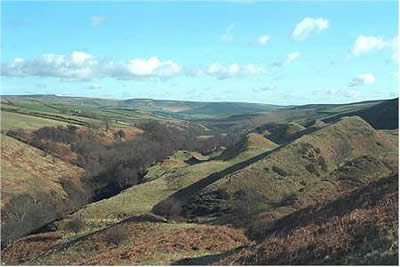
Abney Moor & Bretton Clough from Hucklow
Peak District Walk
Nat Park - Peak District - Abney Moor Chatsworth
County/Area - Derbyshire
Author - Lou Johnson
Length - 8.5 miles / 13.8 km Ascent - 1240 feet / 376 metres
Time - 5 hours 30 minutes Grade - moderate
Maps 

| Ordnance Survey Explorer OL1 | Sheet Map | 1:25k | BUY |
| Anquet OS Explorer OL1 | Digital Map | 1:25k | BUY |
| Ordnance Survey Explorer OL24 | Sheet Map | 1:25k | BUY |
| Anquet OS Explorer OL24 | Digital Map | 1:25k | BUY |
| Ordnance Survey Landranger 110 | Sheet Map | 1:50k | BUY |
| Anquet OS Landranger 110 | Digital Map | 1:50k | BUY |
| Ordnance Survey Landranger 119 | Sheet Map | 1:50k | BUY |
| Anquet OS Landranger 119 | Digital Map | 1:50k | BUY |
Walk Route Description
Click image to see photo description.
This Peak District walk starts from alongside the minor road between Great Hucklow and Bretton (grid ref. SK190781). From here the are extensive views over the White Peak to the south although the walk concentrates on the gritstone of Abney Moor and the surrounding area.
Leave the road and take the path north. It drops steeply into Bretton Clough with large-scale evidence of landslides to your right. Climb out of the valley to Grange Farm and head across the moor towards Robin Hood's Cross. Before reaching the latter point turn right on the track that leads into Shatton Lane. Contouring above the Hope valley there are good views to the Castleton Ridge, the Kinder Plateau, the moors to the north and east of Ladybower Reservoir and Stanage Edge.
Continue past Offerton Hall, taking the footpath off to the left which leads you to Callow Farm. Go down through Callow Wood climbing to reach the lane and then across fields to pass Hoghall on your left. Tor Farm is your next objective as you follow the valley westwards to reach Stoke Ford.
The scenery has changed again. After the Abney Moor and the green farm lands around Offerton Hall you turn into Bretton Clough. This area is particularly pleasant and climbing to Nether Bretton it is hard to imagine you are so close to civilisation. All too soon you reach the road along the edge at Bretton Mount where there is a pub perfectly placed for a refreshing drink. A short walk west along the road leads you back to your car.
Other walks nearby
| Walk 3620 | Bretton Clough & Abney Moor | easy/mod | 6.0 miles |
| Walk 1270 | Abney Circular | easy/mod | 7.2 miles |
| Walk 1080 | Shatton Moor and Offerton | easy/mod | 7.5 miles |
| Walk 2573 | Tideswell, Miller's & Cressbrook Dales from Litton | easy | 7.0 miles |
| Walk 1650 | Miller's Dale & Cressbrook Dale from Tideswell Dale | easy/mod | 5.5 miles |
| Walk 2548 | Stanage Edge from Hathersage | moderate | 8.5 miles |
| Walk 1286 | Castleton Great Ridge & Mam Tor | moderate | 8.5 miles |
| Walk 2599 | Kinder Scout and Castleton Ridge from Hope | mod/hard | 13.5 miles |
| Walk 1706 | Win Hill from Hope | easy/mod | 6.5 miles |
| Walk 1014 | Coombs Dale, Longstone Edge & Pilsley from Calver | moderate | 10.0 miles |
Recommended Books & eBooks
Walking in Derbyshire
 Walking guidebook to 60 circular day walks in Derbyshire and the Peak District. Includes the Derwent, Wye and Trent river valleys, near Derby, Matlock, Glossop, Bakewell and Ripley. Routes range from easy to moderate and are between 4 and 14km (2 to 10 miles). Walks focus on places of interest, from Stone Age forts to castles to grand estates.
More information
Dark Peak Walks
 Guidebook to 40 walks in the Dark Peak area of the Peak District National Park. 35 circular routes for most abilities, from 8km to 19km, around Edale, Marsden, Fairholmes, Baslow and Castleton, including Kinder Scout and Mam Tor, and 5 longer (25km to 45km) routes highlighting the best of the Gritstone Edges, High Moorland and Deep Valleys.
More information
Messaging & Social Media
Message Walking Britain and follow the latest news.

Mountain Weather
Stay safe on the mountains with detailed weather forecasts - for iOS devices or for Android devices.