Snowdon & Cwm Llan horseshoe
Snowdonia/Eryri Walk
Nat Park - Snowdonia - Snowdon Crib Goch
County/Area - Gwynedd
Author - Stephen Starkey
Length - 13.0 miles / 21.1 km Ascent - 6270 feet / 1900 metres
Time - 12 hours 50 minutes Grade - very hard
Maps 

| Ordnance Survey Explorer OL17 | Sheet Map | 1:25k | BUY |
| Anquet OS Explorer OL17 | Digital Map | 1:25k | BUY |
| Ordnance Survey Landranger 115 | Sheet Map | 1:50k | BUY |
| Anquet OS Landranger 115 | Digital Map | 1:50k | BUY |
Walk Route Description
Click image to visit gallery of 12 images.
The Crib Goch - Snowdon - Y Lliwedd horseshoe from Pen-y-Pass is justifiably and understandably regarded as one of the classic mountain walks anywhere in the UK. For me though it is a walk with problems - the inevitable queue to cross Crib Goch caused by it's ever increasing popularity; the horrible descent down the scree at the top of the Watkin Path; the hordes of tourists walking 50 metres or so from the train "to bag" Snowdon. However, I still regard Snowdon as a magnificent mountain, so I wanted a different route - particularly given a glorious weather forecast for a Bank Holiday Saturday. My answer was a horseshoe from the South that avoids the Crib Goch queue and the horrible scree descent of the Watkin Path but still takes in many of the classic parts of Snowdon. The route uses less frequented paths and visits other peaks for alternative aspects of Wales' highest.
This Snowdonia (Eryri) route involves a lengthy scramble descent from Y Lliwedd but there are no major difficulties in the descent provided you stick to the main 'path'. Sections of the 'path' to Gallt Y Wenallt are, at best, vague, and the descent from Yr Aran is pathless so both these sections require proficiency with a map and compass.
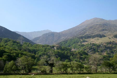
The start is the busy car park alongside the A498 at Nant Gwynant (Grid ref. SH627506). On a clear day, looking up the valley across the road you have the incentive of being able to see parts of the spectacular Snowdon ridges you will be seeing up close later in the day. From the car park, head SW along the road for about 100m to where a waymarked footpath can be seen on the other side of the road. Ignore the lane / path beyond the large metal gate even though on most maps this will be marked as the Watkin Path. Instead, climb the steps and pass through the smaller wooden gate to follow a newly created lower section of the Watkin Path. The path passes through a pleasant deciduous woodland area, crossing small streams by means of newly constructed footbridges. The new section of the Watkin Path eventually curves round to the NE and rejoins the original route at a pair of metal gates at the (just visible) disused mine incline (Grid ref SH626512).
Continue ahead on the well maintained Watkin Path that climbs gently as it swings around Castell. Along this section there are wonderful views to the right across the lower part of Cwm Llan towards the Gallt y Wenallt "ridge". Looking ahead up the Cwm Llan valley, you will see a series of waterfalls alongside a small woodland. Look carefully at the edge of a second group of trees just above the waterfalls and you may be able to make out a slab bridge across the stream. We are heading for this bridge. For the moment, continue to follow the Watkin Path as it continues to work its way gently up the lower part of Cwm Llan. When you arrive at a wall with a wooden gate (Grid ref SH622516), do not go through the gate to follow the main path but turn right, keeping the wall on your left and descend a short way to an old metal gate that gives access on to the slab bridge to cross Afon Cwm Llan. The bridge takes you across the river at a reasonable height above a sizeable pool of beautiful clear water.
After crossing Afon Cwn Llan on the slab bridge ignore the stile on your left and follow the path uphill in a NE direction climbing across the field towards a wood. Cross the stile and continue on the pleasant path that climbs steadily along the Southern edge of the mixed woodland. As you climb, it is worth taking a minute to look back where the Watkin Path shows where you have been and the shapely Yr Aran beyond shows where you have still to go. At the end of the wood the path crosses a wall then climbs again on a lovely grassy path to meet another wall next to a complex of gates. Ignore the obvious path ahead through the gate but turn back to the left through another gate to pick up a broad grassy path. After about 40m the path doubles back to the right to continue heading NE once more.
Shortly after crossing a tributary of the Afon Merch, the path starts to follow the line of a wall. At grid ref SH633529 a footbridge takes you across a second tributary of the Afon Merch and at this point some old mine workings come into view. As you approach the old mine workings you will see a faint, narrow grassy path veering off to the left. This path by-passes the old mine workings and leads up to another disused mine level. Following this path is the easier navigation option. However, the more interesting option is to continue ahead to the old mine workings. From the old mine workings, continue ahead on the rock piles to cross the stream bed and pass to the right of the rock outcrop (not indicated on OS map) by staying just to the left of the wall. Cut back to the left (NW) just before the next outcrop (this one is shown on the OS map) and you will soon intersect the faint grassy path that has come across from the level described earlier.
The path now becomes vague at best and the ground is soft in places. However navigation is reasonably simple as you are basically following the line of the shallow valley (grid bearing approx 070) towards the ridge ahead and you should stay to the North (left) of a small stream. As you get closer to the ridge, the path starts to become more obvious again and then you will meet a path crossing the one you are following. You could just turn left here but I would recommend a short detour by turning right and taking in the summit of Gallt y Wenallt. My main reason for the detour the first time was to tick another box on the list of Snowdonian 2,000 ft plus peaks. Now I know what a superb view you get of the Snowdon Horseshoe from the summit of Gallt y Wenallt and it is a view the guidebook disciples will invariably miss.
From the summit, retrace your steps back to the path junction then continue ahead. Although not shown on the OS map, there is a clearly visible and quite good path that leads across a couple of minor tops before climbing to meet the traditional Snowdon Horseshoe path rising from Llyn Llydaw towards Y Lliwedd. Here you will be able to soak in the inspiring views of Y Lliwedd, Snowdon, Garnedd Ugain and, across Llyn Llydaw, Crib Goch - no doubt teeming with 'ants'.
Turn left (SW) along the Horseshoe path and start the ascent of Y Lliwedd, via Lliwedd Bach and then the East Peak before topping out on the West Peak - the highest point of Y Lliwedd. Although rocky in places and quite steep in others, the climb is never difficult or exposed - even when the ridge narrows significantly near the West Peak. If you look East over the edge from West Peak, there is a reasonable chance you will see some colourful little dots climbing up what I am assured are some of the best climbs in Wales.
The descent from Y Lliwedd's West Peak is steep and rocky throughout. Although scrambly in nature, it is never difficult providing you keep towards the left of the rocks. You will soon arrive at Bwlch Ciliau which makes a wonderful rest stop and is where the Watkin Path rejoins our route. After leaving Bwlch Ciliau heading NW towards Snowdon, the first 700m or so are easy going on a good path with a gentle incline. On arriving at the rocks of Bwlch y Saethau that all changes. The path is still quite clear but the gradient cranks up significantly and the path becomes loose scree. You will see a number of different routes in various places but the best advice is to stay on the left most option at all times and avoid getting too high too soon as this will lead you towards the dangerous rock faces of Clogwyn y Garnedd. As you struggle up the relentlessly steep incline, it may not be much consolation, but it is a lot easier to walk up this path than it is to walk down. Eventually your efforts will bring you to a broader ridge next to the landmark finger rock on Bwlch Main.
From here turn right (NNE) to follow the obvious path to the summit of Snowdon. If you follow this route in 2007 or the early part of 2008, the path will take you past the eye-sore building site where the new summit station and café complex are being built. The positive side of the building site is that, with the mountain railway only running as far as the Halfway Station during the building programme, you can be sure that all of the masses you are sharing the summit with have walked at least half way up. On a clear day, the views from the top of Wales' highest take some beating.
If you are starting to feel tired, miss out the next bit. However, if you've still got the energy, it is worth descending NW from the summit on the obvious (Llanberis) path alongside the railway. At Bwlch Glas when the Pyg Track and Miners Track branch off to start their descent to the East, continue around the ridge and climb to the summit of Garnedd Ugain - Wales' second highest. The summit offers great views along the Crib y Ddysgl ridge to Crib Goch, reveals real gnarly views of Snowdon's East Face and gives great views across Glaslyn to the Y Lliwedd ridge you've come across earlier. Having admired the views, retrace your route back to Snowdon.
From the summit head SSW back past the "summit station" and on to the finger rock at Bwlch Main. Ignore the Watkin Path ascended earlier and continue descending the South Ridge of Snowdon. This is a delightful, airy ridge with an easy path. However, if you want to get an adrenaline rush and feel the need to get "hands on rock", there are scrambling opportunities along the way. Just before the shapely peak of Clogwyn Du the path splits. Ignore the path off to the right - this is the Rhyd Ddu path and following it will entail either a big detour, an expensive taxi ride or may be both. Instead stay on the ridge path that climbs the summit of Clogwyn Du.
From there continue South along the (probably) quiet ridge path, passing the minor top of Allt Maenderyn on the way to a path junction at Bwlch Cwm Llan. All the while, the bulk of Yr Aran becomes ever more imposing. At the boggy col, it is decision time. The easiest option (and the one to go for if you are tired) is to turn left (East) and follow the clear path down in to Cwm Llan. Initially the descent is quite steep and tiring but it soon eases. After a long dry spell this path is quite pleasant but at other times it can be very boggy in places. The main route however continues ahead to climb the outlying peak of Yr Aran by following the faint path that handrails the right hand side of the wall up the deceptively steep slope. When you arrive at a stile and emerge on to the Eastern shoulder, turn right for the final push to the summit. Although the height gain from Bwlch Cwm Llan to Yr Aran's summit is only a relatively modest 235m, coming this late in the day, it is a big "ask" of the legs and lungs. The reward is a wonderful place from which to view Snowdon and reflect on the day's achievements.
From the summit descend back down the Eastern ridge to the stile but don't cross it, rather turn right and follow the wall for about 750m. When the wall starts to bend round to the SE and S, pass through a gap in the wall then walk on a grid bearing of 072 for 200m to pass beyond the top of some crags before descending quite steeply on a grid bearing of 358 for 175m. From here you should be able to see the main path below and you should aim for the point where the disused mine level leads off NE at grid ref SH619518. Follow the path along the old mine level to drop down to the bottom of the Cwm Llan valley and it's junction with the Watkin Path.
A worthwhile diversion here is to turn left and follow the broad path up the valley for about 500m to the famous Gladstone Rock at the point where the 83 year old prime minister addressed the throngs to commemorate the creation of the Watkin Path by the workforce of the local mine owner and MP. Retrace your route back from the rock and continue heading along the main path back down the valley. You will shortly arrive at the wooden gate where you turned off the Watkin Path several hours ago on the outward journey. All that remains now is to follow the easy path back down hill and then through the woodland to arrive back at the car park.
Other walks nearby
| Walk 3058 | Llyn yr Adar & Llyn Edno from near Bethania | moderate | 9.0 miles |
| Walk 1427 | Craflwyn circular from near Beddgelert | easy/mod | 2.5 miles |
| Walk 2150 | Llyn Dinas and Cwm Bychan from Beddgelert | easy/mod | 6.0 miles |
| Walk 2560 | Moel Hebog, Moel yr Ogof & Moel Lefn from Beddgelert | mod/hard | 6.5 miles |
| Walk 1799 | Moel Hebog | moderate | 5.5 miles |
| Walk 1988 | Beddgelert, Moel Hebog, Meol yr Ogof & Moel Lefn | mod/hard | 6.8 miles |
| Walk 3074 | Mynydd Sygun | moderate | 4.5 miles |
| Walk 3231 | Moel Hebog, Meol yr Ogof and Moel Lefn from Beddgelert | mod/hard | 6.8 miles |
| Walk 1426 | Aberglaslyn and Cwm Bychan | easy/mod | 5.8 miles |
| Walk 1089 | Snowdon by the Pyg and Miner's Tracks | moderate | 7.5 miles |
Recommended Books & eBooks
The Wales Coast Path
 A single guidebook to walking the whole Wales Coast Path - 1400km (870 miles) the length of Wales from Chester to Chepstow, including Anglesey, described in 57 stages. The route passes through the Snowdonia and Pembrokeshire National Parks and many AONBs and can be linked with the Offa's Dyke Path for a complete circuit of Wales.
More information
The Cambrian Way
 Guidebook to the Cambrian Way, a challenging three-week mountain trek through Wales from Cardiff to Conwy. The 470km un-waymarked route is presented from south to north. Often sticking to long, beautiful ridgelines, it crosses wild and rugged terrain and visits many of Wales's highest mountains, including Snowdon.
More information
Messaging & Social Media
Message Walking Britain and follow the latest news.

Mountain Weather
Stay safe on the mountains with detailed weather forecasts - for iOS devices or for Android devices.