Helvellyn via Striding Edge from Glenridding
Lake District Walk
Nat Park - Lake District - Lake District Eastern Fells
Wainwrights - Birkhouse Moor, Helvellyn
County/Area - Cumbria
Author - Lou Johnson
Length - 9.5 miles / 15.4 km Ascent - 3250 feet / 985 metres
Time - 8 hours 0 minutes Grade - hard
Maps 

| Ordnance Survey Explorer OL5 | Sheet Map | 1:25k | BUY |
| Anquet OS Explorer OL5 | Digital Map | 1:25k | BUY |
| Ordnance Survey Landranger 90 | Sheet Map | 1:50k | BUY |
| Anquet OS Landranger 90 | Digital Map | 1:50k | BUY |
Walk Route Description
Click image to visit gallery of 6 images.
Striding Edge is a popular and classic route to the summit of Helvellyn. The walk is a perfect mountain excursion and with a traverse of Striding Edge the walk becomes a special day that you will remember for many years to come. Most walks into the mountains should be made in good visibility and this is no exception. Because of the nature of Striding Edge you should also avoid high winds, snow and ice (unless very experienced) and poor visibility.
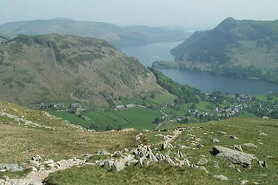
This excellent Lake District walk starts in Glenridding where there is a large car park (grid ref. NY386169) adjacent to the excellent Tourist Information Office with an up to date weather forecast posted in the window. We returned to the main road and took the lane that follows the south side of the beck through the camp site. Following the rising footpath alongside Mire beck we climbed rapidly into Little Cove soon emerging onto the ridge with a good view across Grisedale to the northern face of St Sunday Crag. The gradient eases here and the reconstructed path soon gains height in a series of gentle zig-zags onto Birkhouse Moor.
You first see Helvellyn as you reach the ridge of Birkhouse Moor. Ahead is the fine horseshoe you are about to undertake. To the left of Helvellyn the craggy crest of Striding Edge, whilst to the right Swirral Edge links the summit plateau with the shapely peak of Catstye Cam. Follow the wall south-west to the quaintly named "hole in the wall". As you stride out, the next two or three hours of your walk become clearer, perhaps making the adrenaline flow as you recall the stories of daring and high adventure associated with Striding Edge.
Striding Edge is an arrete between Nethermost Cove to the south and Red Tarn to the north. The highest point on the arrete is High Spying How. In places there are significant drops on either side, but nowhere on the ridge do you need to suffer exposure that makes you feel uncomfortable. If you are in the mood, you can stay on the top of the ridge. In many ways it is easier than following the many paths at lower levels. However if you feel uncomfortable drop down to a lower path and keep within your limits. The only tricky section is the bad step -a clamber down ten or fifteen feet with good hand holds, which can be avoided on the left by using a path.
Having successfully negotiated Striding Edge the final ascent onto the Helvellyn plateau is probably the most tricky section of the whole walk. A steep climb on badly eroded ground make this a very uncomfortable ascent. In hindsight it is probably better to tackle it head on, although the path to the right does eventually lead to easier ground. After a quarter of an hour of cursing you finally reach the summit and are rewarded with excellent views in every direction. However the most rewarding is the retrospective view along the length of Striding Edge, which looks even more impressive from this elevated position.
Before heading back to Glenridding, I took the opportunity to "bag" Lower Man. This satellite of Helvellyn provides a different perspective giving you the chance to amble along the edge of Brown Cove with its impressive crags. Returning to Helvellyn the exit path onto Swirral Edge is easy to find. The descent is steep in places, but is helped by stable rock and plenty of hand holds. If you can cope with Striding Edge then this should present no problems at all. Ahead along the ridge is the summit of Catstye Cam. The short easy ascent is worth the extra effort with a brilliant view down towards Glenridding and a last look at Striding Edge across Red Tarn.
Returning to the foot of Swirral edge we ambled down to Red Tarn. Relaxing here for a few minutes you are able to recall the highlights of crosssing Striding Edge on the way to Helvellyn's summit. The path back to Glenridding following Red Tarn Beck is good and you are soon back at the car park .... and the routine of daily life ...
Other walks nearby
| Walk 1230 | Birks & Arnison Crag | moderate | 5.5 miles |
| Walk 1520 | Helvellyn & Fairfield Horseshoe from Patterdale | very hard | 13.0 miles |
| Walk 2047 | Place Fell | moderate | 7.5 miles |
| Walk 2425 | Boredale Circular from Patterdale | mod/hard | 11.5 miles |
| Walk 3670 | Angle Tarn and Hayeswater | moderate | 8.3 miles |
| Walk 1110 | Angletarn Pikes | moderate | 7.0 miles |
| Walk 2060 | The Angletarn Pikes and Brock Crags from Hartsop | moderate | 8.0 miles |
| Walk 3388 | Hayeswater and Angle Tarn from Hartsop | mod/hard | 11.5 miles |
| Walk 2386 | Red Screes via Dove Crag | mod/hard | 8.6 miles |
| Walk 2039 | Gowbarrow Fell circular | moderate | 3.5 miles |
Recommended Books & eBooks
Walking the Lake District Fells - Buttermere
 Part of the Walking the Lake District Fells series, this guidebook covers a wide range of routes to 32 Lakeland summits that can be climbed from the Buttermere, Lorton and Newlands valleys, with highlights including Haystacks, High Stile, Grasmoor and the fells of the Coledale Round. Suggestions for longer ridge routes are also included.
More information
Walking the Lake District Fells - Keswick
 Part of the Walking the Lake District Fells series, this guidebook covers a wide range of routes to 30 Lakeland summits that can be climbed from Keswick, Whinlatter, Bassenthwaite, Caldbeck, Mungrisdale and Threlkeld, with highlights including Skiddaw and Blencathra. Includes suggestions for longer ridge routes.
More information
Messaging & Social Media
Message Walking Britain and follow the latest news.

Mountain Weather
Stay safe on the mountains with detailed weather forecasts - for iOS devices or for Android devices.