Cadair Idris by the Pony Path
Snowdonia/Eryri Walk
Nat Park - Snowdonia - Cadair Idris
County/Area - Gwynedd
Author - Lou Johnson
Length - 11.0 miles / 17.9 km Ascent - 2820 feet / 855 metres
Time - 8 hours 20 minutes Grade - mod/hard
Maps 

| Ordnance Survey Explorer OL23 | Sheet Map | 1:25k | BUY |
| Anquet OS Explorer OL23 | Digital Map | 1:25k | BUY |
| Ordnance Survey Landranger 124 | Sheet Map | 1:50k | BUY |
| Anquet OS Landranger 124 | Digital Map | 1:50k | BUY |
Walk Route Description
Click image to visit gallery of 5 images.
Cadair Idris is a popular summit visited by thousands of people each year and is one of the highlights of Southern Snowdonia (Eryri). The highest point of a long complex ridge extending inland from the coast near Tywyn, it offers a suitable objective for a walk. Routes of ascent vary in difficulty with the southern route from Minffordd offering the steepest and most dramatic approach for walkers. The northern flanks are less steep with a number of different approaches possible including the route chosen for this excursion into the hills. (See walk 1204 for details of the southern ascent route from Minffordd)
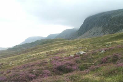
This Snowdonia (Eryri) walk starts from the small car park at Ty-nant (grid ref. SH697152) turn right onto the lane and follow this west for a few hundred yards. Just before the telephone on your left take the track that leads onto the "pony path", which trends south-west across rising ground. Ahead are the northern cliffs of Cadair Idris with some sections looking particularly formidable. Over recent years this popular "tourist" route has seen many improvements and progress is quite straightforward. Even where the ground steepens, zig-zags make upward progress quite easy.
Emerging onto a wide col, the route for the summit heads east (to your left) with the main path fairly obvious even in cloud. Rising steadily across the flanks of the subsidiary summit of Cyfrwy, the path is often stony but never difficult. On this particular occasion the cloud base was around 600 metres (2,000 feet) and no difficulties were experienced finding the route. However one must be careful when the path nears the top of the cliffs. Turning right along the edge of the precipice you have fine views down to Llyn y Gadair below. The steady climb continues until some easy scrambling amongst rocks takes you to the summit trig point.
If you are used to mountain walking then this is an easy ascent for a mountain of such stature. The view is wide-ranging although on this occasion the cloud only lifted for a few seconds at a time giving tantalising glimpses of the mountain and coastal scenery for which the summit is renowned. On the subject of weather it is worth remembering that Cadair Idris, because of its location, does see some rapid changes in conditions. In addition it can be clear and sunny elsewhere yet this summit keeps an annoying cap of cloud.
It is well worth spending some time on the summit as there is much of interest. A short walk south gives excellent views down to dramatic Llyn Cau, which is seen to better advantage when approaching from Minffordd. Quite rare on British mountains, the summit also has a substantial stone built hut which can offer shelter in inclement weather. If you are short of time or energy then you should retrace your steps and follow the outward route back to the car park. However for the more adventurous the onward route along the ridge to Gau Craig is well worth the effort.
Leaving the summit on the path heading east, ignore the path descending steeply to Llyn y Gadair, instead following the rim of the northern cliffs towards the rounded summit of Mynydd Moel. Like most of this walk, the going is easy and you soon reach the top. Only a 100 feet (30 metres) lower than Cadair Idris you are able to enjoy the view in peace as very few walkers bother to visit this summit. Views are good in both directions along the northern cliffs and further afield you can pick out many of the Welsh mountains.
Continuing east, the path follows the cliffs to descend quite steeply to reach an area of upland moorland. In theory the path follows the fence but sections of soft ground mean that easier going can be found away from the general line. The final summit of the walk is Gau Craig, the highest point of the impressive south facing crags marked on maps. A small cairn indicates the summit, which is a perfect place to linger with little chance of being disturbed.
The safest descent is to move initially north west for approximately 250m, crossing the fence, before following the ridge NE down the fence line to approx 520m ASL (approx 750m from the summit at grid ref. SH745146) before again turning north west down a distinct quad bike track to the footpath which turns to a Bridleway at SH7441 1527 and down to the lane Maes Goch from there.
Two options are available from here. The most obvious is to use the lane as far as Pandy gader and then using the footpaths heading west to the Gwernan Lake Hotel just along the lane from where you started. The second option is to descend into Dolgellau using lanes and paths through the woods to explore this interesting town. Using a local taxi firm we arranged a lift back to Ty-nant car park not wanting to walk along the road - or at least that was our excuse....
Other walks nearby
| Walk 1851 | Cregennen Lakes & Pared y Cefn-hir | easy/mod | 2.5 miles |
| Walk 1204 | Cadair Idris Minffordd Path | mod/hard | 6.0 miles |
| Walk 2100 | Circuit of Cadair Idris from Minffordd | mod/hard | 11.0 miles |
| Walk 3229 | Mawddach circular | moderate | 9.0 miles |
| Walk 2450 | Llynnau Cregennen & Mawddach Estuary | moderate | 8.4 miles |
| Walk 2475 | The Dyfi Hills Ridge | mod/hard | 9.8 miles |
| Walk 2570 | Cadair Idris from Llanfihangel-y-pennant | mod/hard | 10.0 miles |
| Walk 2707 | Tyrrau Mawr and Craig-y-llyn from Llanfihangel-y-pennant | moderate | 9.5 miles |
| Walk 2334 | The Torrent Walk near Dolgellau | easy | 1.6 miles |
| Walk 1646 | The Precipice Walk | easy | 3.5 miles |
Recommended Books & eBooks
Mountain Walking in Snowdonia
 Guidebook to 40 of Snowdonia's best day walks, with routes up Snowdon and Tryfan, including the Snowdon Horseshoe, Cadair Idris, Y Garn and The Rhinogs. The routes range from Grade 1 scrambles like Crib Goch or Bristly Ridge, to riverside and forest walks. Includes details of a 2-day traverse of all 15 of Snowdonia's 3000ft peaks.
More information
Snowdonia: 30 Low-level and easy walks - North
 Guidebook describing 30 walks in Snowdonia, Wales. Routes are mostly low level and on clear paths and showcase the region's beautiful scenery and rich history and culture. Part of a 2-volume set, this northern volume includes the Snowdon area, the Ogwen and Conwy Valleys, Betws-y-Coed, Beddgelert, Ffestiniog and the coast.
More information
Messaging & Social Media
Message Walking Britain and follow the latest news.

Mountain Weather
Stay safe on the mountains with detailed weather forecasts - for iOS devices or for Android devices.