The Calf from Sedbergh
Howgills Walk
Nat Park - Yorkshire Dales - Howgill Fells
Region - Howgills
County/Area - Cumbria
Author - Lou Johnson
Length - 10.5 miles / 17.1 km Ascent - 2810 feet / 852 metres
Time - 8 hours 0 minutes Grade - mod/hard
Maps 

| Ordnance Survey Explorer OL19 | Sheet Map | 1:25k | BUY |
| Anquet OS Explorer OL19 | Digital Map | 1:25k | BUY |
| Ordnance Survey Landranger 98 | Sheet Map | 1:50k | BUY |
| Anquet OS Landranger 98 | Digital Map | 1:50k | BUY |
Walk Route Description
Click image to visit gallery of 5 images.
The Howgill Fells to the east of the M6 motorway provide superb walking. Seeing few walkers, the grassy paths offer a superb promenade from which to view the surrounding countryside. One warning - care must be exercised as the complex structure of ridges and valleys can be very confusing when visibility is poor. Apart from that head off into the Howgills and you will be surprised why more people aren't enjoying the experience!
Parking is available in the small town of Sedbergh (the one at grid ref. SD657919 is probably best). From here head out along Howgill Lane, passing playing fields and a small housing estate on your left to reach a footpath sign pointing up through Lockbank Farm, which gives quick and easy access to the Fells.
Turn left along the intake wall for a short way climbing steeply on grass before taking a clear path that climbs gradually across the fellside in a northeasterly direction. This leads with ever improving views over Garsdale and Dentdale to the col between Arant Haw and Winder. Reaching the col turn sharp left and follow the clear path to the summit of Winder. The views west are superb including the Lune Valley, the Shap Fells and the Lake District Fells.
Retrace your route back to the col and begin the climb to the summit of Arant Haw. Ignore the path making a direct assault on the summit opting instead to follow the path that climbs more steadily across the southern flanks. Easily graded this route leads to Rowantree Grains where the onward route comes into view with a steep climb to the top of Calders.
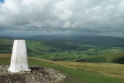
Continue over Calders and Bram Rigg Top to reach the highest point of the Howgills - The Calf. It is worth wandering north a few hundred metres to enjoy the northern Howgills with the long deep valleys so typical of the area before retracing your steps to Rowantree Grains. Stay with the ridge here to easily reach the summit of Arant Haw.
Leaving the last summit of the day it is important you select the correct route. Head due west off the summit to pick up a grassy path that descends easily to Crosdale Beck. At times the path feint but the descent is easy and straightforward. Cross Crosdale Beck and head south with the intake wall to your right. This leads you back to Lockbank Farm and the road back to Sedbergh.
Other walks nearby
| Walk 3008 | Winder & Arant Haw from Sedbergh | moderate | 7.0 miles |
| Walk 2438 | Cautley Spout & the Calf from Sedbergh | moderate | 10.0 miles |
| Walk 2458 | Winder, The Calf & Fell Head | moderate | 9.8 miles |
| Walk 3007 | Fell Head & The Calf from Howgill | moderate | 7.5 miles |
| Walk 3006 | Cautley Spout & The Calf | moderate | 5.5 miles |
| Walk 1393 | Yarlside | moderate | 4.0 miles |
| Walk 1387 | Cautley Spout | easy | 2.0 miles |
| Walk 1052 | Whernside & Dentdale | mod/hard | 12.0 miles |
| Walk 3233 | Dent & Gawthrop | easy/mod | 6.0 miles |
| Walk 2253 | Uldale Falls & Wandale | moderate | 8.5 miles |
Recommended Books & eBooks
Trail and Fell Running in the Yorkshire Dales
 Guidebook to 40 of the best trail and fell runs in the Yorkshire Dales National Park. Ranging from 5 to 24 miles, the graded runs start from bases such as Ribblehead, Dent, Sedbergh, Malham and Grassington and take in the region's diverse delights, from castles and waterfalls to iconic mountains such as Whernside, Ingleborough and Pen Y Ghent.
More information
Outdoor Adventures with Children - Lake District
 Guidebook to 40 outdoor adventures in the Lake District with children under 12, including walking, cycling, orienteering, paddling, boating, hostelling and more. Graded activities for varying age ranges or for families with children of different ages.
More information
Messaging & Social Media
Message Walking Britain and follow the latest news.

Mountain Weather
Stay safe on the mountains with detailed weather forecasts - for iOS devices or for Android devices.