Carrock Fell & High Pike from Mosedale
Lake District Walk
Nat Park - Lake District - Lake District Northern Fells
Wainwrights - Carrock Fell, High Pike
County/Area - Cumbria
Author - Lou Johnson
Length - 7.0 miles / 11.4 km Ascent - 1750 feet / 530 metres
Time - 5 hours 20 minutes Grade - moderate
Maps 

| Ordnance Survey Explorer OL5 | Sheet Map | 1:25k | BUY |
| Anquet OS Explorer OL5 | Digital Map | 1:25k | BUY |
| Ordnance Survey Landranger 90 | Sheet Map | 1:50k | BUY |
| Anquet OS Landranger 90 | Digital Map | 1:50k | BUY |
Walk Route Description
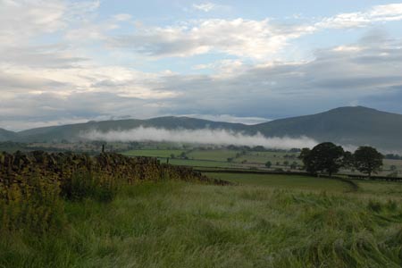
Click image to visit gallery of 6 images.
This Lake District walk explores the most northerly fells of Lakeland together with some of the open common land on the periphery of the National Park. In addition the route offers an insight in some of the mining activity that once thrived in this area. Do not expect rocky terrain, crags or lofty summits. Instead enjoy pleasant walking, good views and grass under your feet on some sections of the route. The start is near Mosedale and takes a direct line of ascent to the summit of Carrock Fell before staying on high ground to visit the summit of High Pike. The return route descends to follow Carrock Beck back to the start.
The start (Grid ref. NY353337) is near to Stone Ends Farm on the minor road going north from Mosedale towards Hesket Newmarket. There is plenty of space for parking on the grass verge of this common land. You should park to the north of the small beck, Further Gill Sike, coming off the fell. After careful inspection of the slope ahead, you should be able to see the path climbing steeply from right to left across the fellside just to the left of the crags. The path is most obvious where it crosses a section of light-coloured scree. Having located the path, climb steeply with the scree not causing any major problems. Reaching the beck, the path turns and follows the beck onto the open fell. The path continues making a bee-line for the eastern summit outcrop before continuing towards the main summit which is topped by a substantial cairn. The view is wide ranging covering the Pennines, the Vale of Eden and many Lakeland Fells.
To continue, walk west on a clear path passing Round Knott and Miton Hill towards the main track coming up across the flank of Low Pike from Wood Hall. Reaching this track, turn right and shortly after bear left to follow the clear path to the summit of High Pike with its stone bench and trig point. From here the view north across the Solway Firth to Scotland is full of interest. The view south is a surprise with Scafell, Scafell Pike, Esk Pike, Bow Fell and Crinkle Crags all in view.
Descend from High Pike by retracing your steps to the main track. Turn sharp left and start to descend northeast across the flank of High Pike. Reaching a junction of tracks (Grid ref. NY324354) turn right and descend past the old mine workings of Driggeth Mine towards Carrock Beck. Stay on this track to reach another junction (Grid ref. NY341351) where you bear right to follow the track nearest the beck. This leads to the tarmac lane (Grid ref. NY349351). Turn right along the lane, using the new footbridge by the Ford, and continue along the grass verge back to where you have parked. On the way back you may meet some of the wild ponies. On occasions they can be too friendly having been fed by some people passing this area.
Other walks nearby
| Walk 1354 | Bannerdale Crags & Souther Fell | moderate | 7.5 miles |
| Walk 2351 | Caldbeck & Watersmeet from Hesket Newmarket | easy | 4.3 miles |
| Walk 2612 | Roughton Gill, Caldbeck Fells | easy | 4.5 miles |
| Walk 2390 | High Pike from Fell Side | moderate | 5.2 miles |
| Walk 1008 | Blencathra via Sharp Edge | mod/hard | 5.0 miles |
| Walk 1188 | Blencathra via Hall's Fell ridge | mod/hard | 6.0 miles |
| Walk 3470 | Blencathra via Foule Crag from Scales | mod/hard | 8.0 miles |
| Walk 1506 | Sharp Edge & Blencathra from Scales | mod/hard | 5.0 miles |
| Walk 1177 | Great Sca Fell via Trusmadoor | moderate | 6.5 miles |
| Walk 3283 | Great Cockup and Meal Fell from Longlands | moderate | 6.0 miles |
Recommended Books & eBooks
Walking the Lake District Fells - Buttermere
 Part of the Walking the Lake District Fells series, this guidebook covers a wide range of routes to 32 Lakeland summits that can be climbed from the Buttermere, Lorton and Newlands valleys, with highlights including Haystacks, High Stile, Grasmoor and the fells of the Coledale Round. Suggestions for longer ridge routes are also included.
More information
Walking the Lake District Fells - Wasdale
 Part of the Walking the Lake District Fells series, this guidebook covers a wide range of routes to 25 Lakeland summits that can be climbed from the Wasdale, Eskdale and Ennerdale valleys, with highlights including Scafell Pike, Great Gable and Pillar. Suggestions for longer ridge routes are also included.
More information
Messaging & Social Media
Message Walking Britain and follow the latest news.

Mountain Weather
Stay safe on the mountains with detailed weather forecasts - for iOS devices or for Android devices.