Tintern, Devil's Pulpit & Brockweir
Wye Valley Forest of Dean Walk
Region - Wye Valley Forest of Dean
County/Area - Monmouthshire & Gloucestershire
Author - Lou Johnson
Length - 7.5 miles / 12.2 km Ascent - 1300 feet / 394 metres
Time - 5 hours 0 minutes Grade - moderate
Maps 

| Ordnance Survey Explorer OL14 | Sheet Map | 1:25k | BUY |
| Anquet OS Explorer OL14 | Digital Map | 1:25k | BUY |
| Ordnance Survey Landranger 162 | Sheet Map | 1:50k | BUY |
| Anquet OS Landranger 162 | Digital Map | 1:50k | BUY |
Walk Route Description
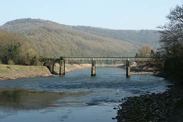
Click image to visit gallery of 5 images.
The Wye Valley is varied and full of interest. This walk starts from near the ruins of Tintern Abbey located alongside the A466 Chepstow to Monmouth road on the Welsh side of the river. Parking is limited in Tintern and you will probably be better avoiding busy periods of the year. For this walk a start from the Abbey (Grid ref. SO532001) is assumed.
Follow the signed path and head upstream with the Wye to your right. The path leads out onto the A466. Turn north for a short way before crossing a substantial footbridge (Grid ref. 530003) to reach the other side of the river. Turn south soon reaching the old railway with a disused tunnel on your left. Continue on the old railway for approximately three kilometres with glimpses through the trees of Tintern Abbey on your right.
At a fork in the path (Grid ref. 540982) left climbing to a further path junction. Turn sharp left here and continue on a track uphill to a T-junction. Ignore the tracks left and right, instead taking the path opposite. This climbs steeply through the woodland to reach another track. Turn right and after a few yards locate a waymark (which recent reports suggest has been removed) on your left and follow this narrow path to reach the Offa's Dyke Path.
Turn left along this National Trail to reach the Devil's Pulpit from where there is an excellent view down to Tintern Abbey and the Wye Valley. Continue on the Offa's Dyke Path, ignoring short cuts signed left back to Tintern. Eventually you leave the woodland (Grid ref. 546010) to descend across to reach a green lane. Turn left here to follow the green lane past stables into the village of Brockweir.
Cross the river using the road bridge to regain Wales turning left down some steps onto a path that follows a further section of the old railway. This leads through a visitor centre located in the old Tintern Station where a number of wood sculptures are on view.
Stay on the old railway heading south to reach the point where the railway once crossed the River Wye. Descend steps on your right to join a pleasant riverside path that leads via Tintern Parish Church onto the main road. All that remains is to follow the road back to the start perhaps taking the opportunity to visit Tintern Abbey.
Other walks nearby
| Walk 2832 | The Wye Valley | easy/mod | 5.8 miles |
| Walk 1927 | Oldbury-on-Severn & Littleton-upon-Severn | easy | 5.2 miles |
| Walk 3437 | The Severn Estuary from Thornbury | easy/mod | 9.3 miles |
| Walk 3214 | Symonds Yat, High Meadow Woods & Wye Valley | moderate | 12.0 miles |
| Walk 3302 | Symonds Yat Rock and the Biblins | easy/mod | 4.0 miles |
| Walk 1874 | The River Usk from Bettws Newydd | easy/mod | 6.5 miles |
| Walk 3750 | River Severn from Arlingham | easy | 6.0 miles |
| Walk 1258 | The Tyndale Monument | easy/mod | 5.5 miles |
| Walk 2147 | Arlington Peninsula from Saul Junction | easy/mod | 6.2 miles |
| Walk 1877 | Uley Bury & Cam Long Down | easy/mod | 5.5 miles |
Recommended Books & eBooks
Walking in the Wye Valley
 Guidebook to 30 varied walks of 3 - 10 miles, in the valley of the Wye, the most scenic river in England and Wales, between Chepstow in the south and Plynlimon. Landscape ranges from open moorland to wooded gorges and is dotted with the sites of Iron Age hillforts and castles. Centres include Ross-on-Wye, Hereford, Hay-on-Wye and Rhayader.
More information
Walking in the Forest of Dean
 Guidebook to 25 walks in the Forest of Dean, between the Severn and Wye, from 4-mile routes to all-day sections of long-distance trails such as the Offa's Dyke Path and Gloucestershire Way, this guide is ideal for exploring the forest and its history and includes the information needed for walkers of all abilities to explore this ancient area.
More information
Messaging & Social Media
Message Walking Britain and follow the latest news.

Mountain Weather
Stay safe on the mountains with detailed weather forecasts - for iOS devices or for Android devices.