Nappa Cross & Malham
Yorkshire Dales Walk
Nat Park - Yorkshire Dales - Malhamdale
County/Area - North Yorkshire
Author - Lou Johnson
Length - 5.5 miles / 8.9 km Ascent - 1050 feet / 318 metres
Time - 3 hours 50 minutes Grade - easy/mod
Maps 

| Ordnance Survey Explorer OL2 | Sheet Map | 1:25k | BUY |
| Anquet OS Explorer OL2 | Digital Map | 1:25k | BUY |
| Ordnance Survey Landranger 98 | Sheet Map | 1:50k | BUY |
| Anquet OS Landranger 98 | Digital Map | 1:50k | BUY |
Walk Route Description
Click image to visit gallery of 5 images.
This is a quiet Yorkshire Dales walk that avoids the crowds that gather in fine weather on the better known paths in the Malham area. Although it does not visit Malham Cove it still provides you with an excellent prospect of this well known sight. The start is the car park behind the National Park information centre on the southern approach to the village of Malham (Grid ref. SD 900627).
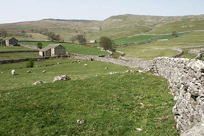
From the car park take the walled track at the western end of the car park and walk north along the track that runs parallel with the main street of the village. Turn left at the first junction (Grid ref. SD 899629) to walk west and then northwest between dry stone walls. At the next junction (Grid ref. SD 896631) fork left. You now pass a number of field barns and the walk has taken on a distinctive Yorkshire Dales feel. Leave the track just before it bends left and follow a clear path across pastures.
The ascent steepens with Pikedaw Hill rising to your right. If you have the energy then a sharp ascent will take you to the summit cairn from where there are excellent views across Malhamdale and surrounding countryside. Passing evidence of old mine workings you reach a wall (Grid ref. SD 874640). Go through the gate and turn right to follow the path alongside wall northwards. Almost immediately you pass the restored Nappa Cross on your right. The path gently descends across limestone moor to reach a junction of paths and tracks (Grid ref. SD 881649). Turn right (east) and follow the track to reach a road.
Go straight across and continue in the same direction on a signed footpath. After a short way you reach a complex path junction (Grid ref. SD 891649). Do not descend into the dry valley. Instead turn right on a clear path that crosses a limestone pavement above the valley. This leads easily across grass soon offering an excellent view of Malham Cove to your left. The path then descends through pastures to reach a road (Grid ref. SD 895637). Turn right (uphill) to the where the road swings right. Here you go left through a gate and cross a field. This path leads into a walled lane (Long Lane) that will lead you back to the start.
Other walks nearby
| Walk 1282 | Malham Tarn & Arncliffe | moderate | 12.5 miles |
| Walk 3092 | Malham Cove, Malham Tarn & Watlowes | easy | 4.4 miles |
| Walk 2385 | Airton & Bell Busk Circular | easy/mod | 6.8 miles |
| Walk 1377 | Calton and Hanlith Moors | easy/mod | 6.5 miles |
| Walk 2066 | Winterburn Reservoir circular | easy | 6.0 miles |
| Walk 1701 | Bordley Hall & Malham Moor from Threshfield Moor | easy/mod | 7.0 miles |
| Walk 2332 | Mastilles Lane & Bordley from Kilnsey | easy/mod | 6.8 miles |
| Walk 3107 | Flasby Fell from Flasby | easy/mod | 6.5 miles |
| Walk 3109 | Rylstone Edges & Cracoe from Rylstone | easy/mod | 6.0 miles |
| Walk 2617 | Nappa Cross & Victoria Cave from Langcliffe | moderate | 9.5 miles |
Recommended Books & eBooks
Walking in the Yorkshire Dales: South and West
 Part of a two-book set, this guidebook describes 44 walks in the southern and western Yorkshire Dales, including the famous 23 mile Three Peaks circuit over Pen-y-Ghent, Whernside and Ingleborough. The other, mostly circular routes of 3½ to 13 miles cover the scenic region between Sedbergh, Kirkby Lonsdale, Settle, Skipton and Grassington.
More information
Walking in the Yorkshire Dales: North and East
 This guidebook contains 43 circular day walks in the north and east Yorkshire Dales. It explores the dales, hills and moors between Kirkby Stephen and Pateley Bridge. Walking ranges from gentle 3 mile strolls to more strenuous day-long rambles across the Howgills, Wensleydale, Swaledale, Nidderdale, Mallerstang and Coverdale.
More information
Messaging & Social Media
Message Walking Britain and follow the latest news.

Mountain Weather
Stay safe on the mountains with detailed weather forecasts - for iOS devices or for Android devices.