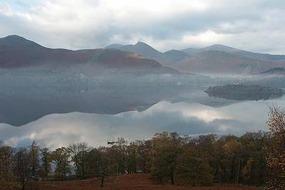
Walla Crag from Great Wood
Lake District Walk
Nat Park - Lake District - Lake District Central Fells
Wainwrights - Walla Crag
County/Area - Cumbria
Author - Lou Johnson
Length - 4.5 miles / 7.3 km Ascent - 1250 feet / 379 metres
Time - 3 hours 30 minutes Grade - easy/mod
Maps 

| Ordnance Survey Explorer OL4 | Sheet Map | 1:25k | BUY |
| Anquet OS Explorer OL4 | Digital Map | 1:25k | BUY |
| Ordnance Survey Landranger 90 | Sheet Map | 1:50k | BUY |
| Anquet OS Landranger 90 | Digital Map | 1:50k | BUY |
Walk Route Description
Click image to visit gallery of 9 images.
The low fells of Lakeland offer many superb walks and this is no exception. Offering grand panoramas over lakes and fells some effort is required to gain some height but the rewards are excellent. In clear weather this Lake District circular walk offers views to some of the highest mountains in England and you will also be rewarded with a grandstand view of Derwentwater and Keswick.
The walk starts in the National Trust car park in Great Wood (Grid ref. NY271211). This can be reached from the B5289 Keswick to Borrowdale road about 2 kilometres south of Keswick. After parking walk locate the southern pedestrian exit. This path leads towards a bridge over Car Gill (Grid ref. NY 271210).
Go over the bridge and continue straight ahead. This path gradually climbs below the crags of Brown Knotts to reach Ashness Bridge, which is often the subject of picture postcards. Having enjoyed the view retrace your steps a short way as far as the wall and take the right hand path.
This path leads uphill with a couple of short sections where you might need hands. The view improves as you get higher with an excellent panorama south, which on a clear day, will include Scafell Pike (England' highest mountain). Eventually the grade eases and ahead you will see the top of Walla Crag, which is located on the other side of the stone wall.
After enjoying the view continue along the path for a short way before crossing the wall into open country once more. The onward route continues north with the wall to your left on a broad easy to follow path. Ahead the views are towards Blencathra. The path descends quite steeply at times to reach a lane at Rakefoot (Grid ref. NY 283221). Go down the lane for a short way keeping a careful watch for a half hidden path on your left (Grid ref. NY 282222) which should be followed down to the bridge over the beck and downhill towards Keswick.
At the first path junction (Grid ref. NY 280223) turn left on a path signed to "Great Wood" Entering woodland you keep left at the first path junction continuing to join a forest track . This leads downhill under Walla Crag to reach Great Wood car park in just over a kilometre.
Note - You can omit the section to Ashness Bridge by taking the signed path on the north bank of Car Gill (Grid ref. NY 271210). This path is steep and is stepped for most of the way and leads you almost directly to the top of Walla Crag.
Other walks nearby
| Walk 2587 | Castlerigg Stone Circle & St John's in the Vale | easy/mod | 8.5 miles |
| Walk 1108 | Ashness Bridge & Grange Fell | moderate | 9.0 miles |
| Walk 3029 | Derwentwater & Walla Crag | easy/mod | 6.5 miles |
| Walk 3037 | High Seat & Bleaberry Fell from Keswick | moderate | 9.0 miles |
| Walk 2321 | Shores of Derwentwater from Keswick | easy | 3.5 miles |
| Walk 2036 | Cat Bells from Gutherscale | easy/mod | 4.0 miles |
| Walk 3525 | Cat Bells (Route 2) | easy/mod | 4.0 miles |
| Walk 3119 | The Newlands Horseshoe - Catbells, Dale Head & Hindscarth | mod/hard | 12.0 miles |
| Walk 1155 | Causey Pike | moderate | 6.3 miles |
| Walk 1268 | Cat Bells & High Spy | moderate | 8.0 miles |
Recommended Books & eBooks
Walking the Lake District Fells - Buttermere
 Part of the Walking the Lake District Fells series, this guidebook covers a wide range of routes to 32 Lakeland summits that can be climbed from the Buttermere, Lorton and Newlands valleys, with highlights including Haystacks, High Stile, Grasmoor and the fells of the Coledale Round. Suggestions for longer ridge routes are also included.
More information
Hadrian's Wall Path
 Hadrians Wall Path guidebook to walk the 84 mile National Trail. Described in both directions, the main description is west to east between Bowness-on-Solway and Wallsend, Newcastle, with extensions to Maryport and South Shields. With extensive historical information related to this World Heritage site and separate 1:25,000 OS map booklet included.
More information
Messaging & Social Media
Message Walking Britain and follow the latest news.

Mountain Weather
Stay safe on the mountains with detailed weather forecasts - for iOS devices or for Android devices.