Tissington Trail - Hartington to Parsley Hey
Peak District Walk
Nat Park - Peak District - Lathkill Dale High Peak
County/Area - Derbyshire
Author - Lou Johnson
Length - 4.0 miles / 6.5 km Ascent - 100 feet / 30 metres
Time - 2 hours 10 minutes Grade - easy
Maps 

| Ordnance Survey Explorer OL24 | Sheet Map | 1:25k | BUY |
| Anquet OS Explorer OL24 | Digital Map | 1:25k | BUY |
| Ordnance Survey Landranger 119 | Sheet Map | 1:50k | BUY |
| Anquet OS Landranger 119 | Digital Map | 1:50k | BUY |
Walk Route Description
Click image to visit gallery of 9 images.
This easy Peak District walk follows a section of the former railway which linked Ashbourne and Buxton. Today it is a well graded path for walkers and cyclists. The start of the walk at the former Hartington station has a pay and display car park and toilets. You could also start the walk at Parsley Hey where there are more facilities including and information centre, café and toilets. The walk includes some fine views across the Derbyshire Dales.
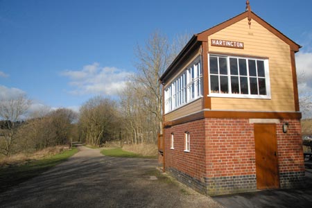
Assuming you start from the Hartington end of the route all you need do is locate the Tissington Trail and walk west for approximately two miles. So as there is no confusion, if you are standing with your back to the restored signal box, then you need to go right.
The route passes through pleasant countryside with dry stone walls and some nice views. Nowhere is the going hard and even after rain the path is usually quite dry under foot. Along the route you will still see evidence of the existence of a railway including some substantial cuttings, bridges and other earthworks. In addition there are still a few other relics to be seen.
As you near Parsley Hey, the High Peak Trail comes in from your right. Ahead is the former station which now bears very little resemblance to the original. It is working a few minutes past the station to see the recently erected Croatian hut which was erected to celebrate Croatia joining the European Union. It is made of local materials and blends well with the surrounding countryside.
To complete the walk return the way you came making sure you follow the Tissington Trail at the junction passed shortly after leaving Parsely Hey.
Other walks nearby
| Walk 1042 | Pilsbury Castle | easy/mod | 5.5 miles |
| Walk 2301 | Biggin & Parsley Hay from Hartington | easy/mod | 9.5 miles |
| Walk 2079 | Beresford & Wolfescote Dales from Hartington | easy/mod | 7.2 miles |
| Walk 1593 | Beresford, Wolfscote & Biggin Dales from Hartington | easy/mod | 6.2 miles |
| Walk 1594 | Biggin, Wolfscote & Beresford Dales from Hartington | easy | 5.5 miles |
| Walk 1595 | Dove Valley & Biggin Dale from Hartington | easy/mod | 6.8 miles |
| Walk 2682 | River Dove & Reynard's Lane from Hartington | easy/mod | 5.6 miles |
| Walk 1410 | Minninglow Hill, Roystone Grange and Cardlemere Lane from Gotham | easy/mod | 5.5 miles |
| Walk 3709 | Sparklow, Crowdicote & Pilsbury Circular | easy/mod | 9.0 miles |
| Walk 1569 | Lathkill Dale & Bradford Dale | easy/mod | 8.2 miles |
Recommended Books & eBooks
Walking in Derbyshire
 Walking guidebook to 60 circular day walks in Derbyshire and the Peak District. Includes the Derwent, Wye and Trent river valleys, near Derby, Matlock, Glossop, Bakewell and Ripley. Routes range from easy to moderate and are between 4 and 14km (2 to 10 miles). Walks focus on places of interest, from Stone Age forts to castles to grand estates.
More information
Dark Peak Walks
 Guidebook to 40 walks in the Dark Peak area of the Peak District National Park. 35 circular routes for most abilities, from 8km to 19km, around Edale, Marsden, Fairholmes, Baslow and Castleton, including Kinder Scout and Mam Tor, and 5 longer (25km to 45km) routes highlighting the best of the Gritstone Edges, High Moorland and Deep Valleys.
More information
Messaging & Social Media
Message Walking Britain and follow the latest news.

Mountain Weather
Stay safe on the mountains with detailed weather forecasts - for iOS devices or for Android devices.