Thames Path - North Greenwich to Cutty Sark
London Walk
County/Area - London
Author - Lou Johnson
Length - 2.5 miles / 4.1 km Ascent - 50 feet / 15 metres
Time - 1 hours 20 minutes Grade - easy
Maps 

| Ordnance Survey Explorer 161 | Sheet Map | 1:25k | BUY |
| Anquet OS Explorer 161 | Digital Map | 1:25k | BUY |
| Ordnance Survey Explorer 173 | Sheet Map | 1:25k | BUY |
| Anquet OS Explorer 173 | Digital Map | 1:25k | BUY |
| Ordnance Survey Landranger 176 | Sheet Map | 1:50k | BUY |
| Anquet OS Landranger 176 | Digital Map | 1:50k | BUY |
| Ordnance Survey Landranger 177 | Sheet Map | 1:50k | BUY |
| Anquet OS Landranger 177 | Digital Map | 1:50k | BUY |
Walk Route Description
Click image to visit gallery of 15 images.
The Thames path runs from the Thames Barrier to the east of London to the source of the river. In the London area there is often a "Thames Path" on either side of the River Thames and this is also the case over the section covered by this walk. Opportunities for crossing the Thames are limited and you need to plan ahead if you wish to swap sides of the River. Generally signs are in place although in one or two places these are inadequate and you need a detailed map and a good sense of direction.
The start can be reached by using the Jubilee line tube, using the Docklands Light Railway Canning Town and then taking the spectacular cable car across the river or reaching North Greenwich via the River Thames ferry service. However you arrive make your way to the River and with the river on your right start walking along the Thames Path.
This description is not a step by step account of the route. The Thames Path, certainly in built up areas, is not always adjacent to the river and often makes short diversions inland to rejoin the riverside walk further along. There are also building works taking place along the riverside and short term diversions are sometimes in place for your own safety. In general on this section route finding is not too problematic.
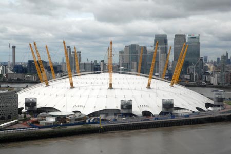
Almost from the start you pass the O2 Arena with its white dome. Across the river on the north bank of the Thames you can see the evidence of large scale urban development which has taken place in the last 20 years or so. Just as you pass the O2 Arena you will be totally oblivious to the fact that deep beneath your feet is the Blackwall Road Tunnel. As you turn the first corner you enter "Blackwall Reach" and you get your first view of Greenwich ahead and Canary Wharf off to the right.
As you continue there are many reminders of this area's past with wharves still in place and much evidence of the Thames's maritime past. As you approach Greenwich you will pass the historic "Cutty Sark" pub which makes a good place for refreshment. Moving onwards you pass Greenwich Hospital founded in 1616 but sadly hemmed in by industrial development on one side.
The Old Royal Naval College is soon passed and you might wish to divert to explore the grounds and other attractions in this area. Details can be found in Walk 1398 which details some of the options available in this historic area. Continuing you soon reach the "Cutty Sark" and suddenly the number of other people has risen dramatically. From here you can continue upstream by following Walk 1471 which will take you through to the Tower of London. Alternatively there is a Docklands Light Railway station and the ferry service along the Thames from Greenwich Pier.
Other walks nearby
| Walk 1398 | Greenwich Museum, Observatory & Park | easy | 2.3 miles |
| Walk 1471 | Thames Path - Cutty Sark to Tower of London | easy | 6.0 miles |
| Walk 1882 | The Limehouse Cut from Bow Locks | easy | 2.0 miles |
| Walk 3084 | Limehouse to Little Venice by the Regent's Canal | easy/mod | 9.0 miles |
| Walk 2651 | The City of London from Hays Galleria | easy | 3.5 miles |
| Walk 1412 | The Monument to Trafalgar Square via Southwark | easy | 4.0 miles |
| Walk 1442 | St Paul's Cathedral to Green Park | easy | 5.6 miles |
| Walk 1310 | Chancery Lane to Trafalgar Square | easy | 4.0 miles |
| Walk 1535 | Snaresbrook to Loughton (Epping Forest) | easy/mod | 8.0 miles |
| Walk 1096 | Highbury & Islington & New River | easy | 1.5 miles |
Recommended Books & eBooks
The Thames Path Map Booklet
 Map of the 180 mile (288km) Thames Path National Trail, from London's Thames Barrier to the river's source near Cirencester in Gloucestershire. This booklet is included with the Cicerone guidebook to the trail, and shows the full route on OS 1:25,000 maps. The easy riverside route takes around two weeks to walk.
More information
Walking in London
 A guidebook to 25 walks in London's green spaces and nature reserves, covering both the city centre and Greater London area. Taking in woods and forests, parks and heaths, canals and rivers, the guide includes a wealth of information about some of the species you might encounter as well as the history and conservation of these areas.
More information
Messaging & Social Media
Message Walking Britain and follow the latest news.

Mountain Weather
Stay safe on the mountains with detailed weather forecasts - for iOS devices or for Android devices.