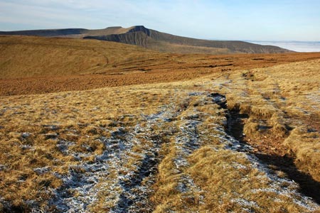
Waun Rydd from Blaen y glyn
Brecon Beacons/Bannau Brycheiniog Walk
Nat Park - Brecon Beacons - Brecon Beacons Central
County/Area - Powys
Author - Lou Johnson
Length - 5.5 miles / 8.9 km Ascent - 1800 feet / 545 metres
Time - 4 hours 30 minutes Grade - easy/mod
Maps 

| Ordnance Survey Explorer OL12 | Sheet Map | 1:25k | BUY |
| Anquet OS Explorer OL12 | Digital Map | 1:25k | BUY |
| Ordnance Survey Landranger 160 | Sheet Map | 1:50k | BUY |
| Anquet OS Landranger 160 | Digital Map | 1:50k | BUY |
Walk Route Description
Click image to see photo description.
This horseshoe route takes you on to a less visited part of the Brecon Beacons and includes the site of a Wellington Bomber that crashed in 1942. The paths are generally easy to follow in good visibility but navigational skills are required in poor visibility.
Start from the Upper Blaen-y-glyn car park (grid ref. SO056175). To start the walk exit the car park, cross the cattle grid and turn right onto the path. The way ahead is initially stepped and climbs steeply onto Craig y Fan Ddu ridge. As the terrain gets easier bear right and follow the rim of the valley below you on your right and continue along the edge of Graig Fan Las to the head of the valley (grid ref. SO057206).
Turn right here and follow the less obvious path that makes for the memorial to the aircraft crash at grid ref. SO061200. You then need to regain height onto the plateau by taking the steep path to the left of the stream gully. Once on the plateau bear right and follow the edge of the crags (Cwar y Gigfran) south to reach a cairn at grid ref. SO066192. Bear half right here with a steep descent as the path heads, roughly south. The terrain becomes less steep and you cross rough moorland to reach a wall. Here you turn right alongside the wall, down to the River Caerfanell (grid ref. SO061161).
Go left over the stile and follow the path beside the river. Reaching a footbridge (grid ref. SO060173), turn right across the bridge. Bear left at the first junction of paths and at the second junction go right and follow the rising path through the forest roughly following a stream with small waterfalls. Reaching a track bear left which leads you back to the car park used as the starting point.
Other walks nearby
| Walk 1283 | Fan y Big from Torpantau | moderate | 8.5 miles |
| Walk 1123 | Brecon Beacons Horseshoe | moderate | 8.5 miles |
| Walk 2934 | The High Peaks of the Brecon Beacons | mod/hard | 10.7 miles |
| Walk 2349 | Pen Y Fan & Corn Du from near Storey Arms | moderate | 4.6 miles |
| Walk 3616 | Fan Fawr from Storey Arms | moderate | 6.0 miles |
| Walk 2400 | Pen y Fan from Cwmgwdi near Brecon | moderate | 5.0 miles |
| Walk 1903 | Pen y Fan & Corn Du from Cwmgwdi | moderate | 7.5 miles |
| Walk 2074 | Highest Peaks of the Brecon Beacons | mod/hard | 11.0 miles |
| Walk 3546 | Pen y Bryn from Pencelli | moderate | 5.0 miles |
| Walk 3536 | Pen y Bryn & Carn Pica from Pencelli | mod/hard | 11.3 miles |
Recommended Books & eBooks
Walking in Carmarthenshire
 Guidebook to 30 walking routes (2 to 10 miles) in Carmarthenshire, south Wales, including sections of Carmarthenshire Coast Path. Walks for all abilities, including coastal, river, forest and hill walks in Cambrian Mountains, Tywi Valley, Y Mynydd Du (Black Mountains) and Brecon Beacons. Easy access from Bristol, Cardiff and Swansea.
More information
Walking on the Brecon Beacons
 45 circular day walks are described in this guidebook to the Brecon Beacons National Park. From west to east, Mynydd Du, Fforest Fawr, the Brecon Beacons and the Black Mountains these mountain and valley routes offer many options, highlighting the natural features. The walks described explore dramatic waterfalls, wooded gorges and upland valleys.
More information
Messaging & Social Media
Message Walking Britain and follow the latest news.

Mountain Weather
Stay safe on the mountains with detailed weather forecasts - for iOS devices or for Android devices.