Redmires Reservoir
Peak District Walk
Nat Park - Peak District - Derwent Edge Sheffield
County/Area - South Yorkshire
Author - Yorkshire Water
Length - 2.5 miles / 4.1 km Ascent - 150 feet / 45 metres
Time - 1 hours 20 minutes Grade - easy
Maps 

| Ordnance Survey Explorer OL1 | Sheet Map | 1:25k | BUY |
| Anquet OS Explorer OL1 | Digital Map | 1:25k | BUY |
Walk Route Description
Click image to see photo description.
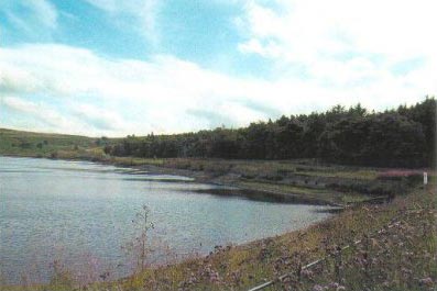
Redmires consists of three tiers of reservoirs. The route starts from the top and descends past each tier before completing a circuit by passing through pleasant woodland which can be seen across the water on the outward route. Located within the Peak District National Park many visitors mention the interesting shapes of reservoirs and often comment on the numbers of wildfowl and waders that can be seen here.
This is one of the free reservoir walks produced by Yorkshire Water who are one of the county's largest landowners, with around 72,000 acres of land spanning National Parks, Areas of Outstanding Natural Beauty, the North York Moors and the Yorkshire Wolds. There is a wide range of walks on offer from gentle strolls around one of their picturesque reservoirs to more adventurous routes. Yorkshire Water have selected some of their top walks for you and split them into three regional packs. Just print them out and off you go.
Each site has its own walk pack that you can easily print out and take along with you. Each pack includes directions to the site, a summary of the walk, a list of facilities available, a detailed route map and route instructions. To download walk descriptions go to Yorkshire Water Walks.
Other walks nearby
| Walk 1541 | Redmire, Stanage & Ughill Moor circular | moderate | 13.0 miles |
| Walk 1479 | Burbage Moor & Redmires from near Ringinglow | easy/mod | 9.8 miles |
| Walk 2235 | Bamford & Stanage Edges | moderate | 9.9 miles |
| Walk 2516 | Moscar, Dale Dike & Shrines Reservoirs | easy/mod | 7.0 miles |
| Walk 2629 | Stanage Edge, Redmires & Hallam Moors | easy/mod | 8.5 miles |
| Walk 1090 | Stanage Edge | moderate | 7.0 miles |
| Walk 1285 | Dungworth & Rod Moor | moderate | 9.4 miles |
| Walk 3540 | The Derwent Edge from Cutthroat Bridge | moderate | 10.0 miles |
| Walk 1579 | Damflask Reservoir | easy | 3.5 miles |
| Walk 2548 | Stanage Edge from Hathersage | moderate | 8.5 miles |
Recommended Books & eBooks
Dark Peak Walks
 Guidebook to 40 walks in the Dark Peak area of the Peak District National Park. 35 circular routes for most abilities, from 8km to 19km, around Edale, Marsden, Fairholmes, Baslow and Castleton, including Kinder Scout and Mam Tor, and 5 longer (25km to 45km) routes highlighting the best of the Gritstone Edges, High Moorland and Deep Valleys.
More information
Walking in the Peak District - White Peak East
 Guidebook describing 42 half-day and day walks in the limestone landscapes of Derbyshire's White Peak, part of the Peak District National Park. One of two volumes, this book covers the east of the region, with potential bases including Bakewell, Eyam, Castleton, Birchover, Matlock and Wirksworth.
More information
Messaging & Social Media
Message Walking Britain and follow the latest news.

Mountain Weather
Stay safe on the mountains with detailed weather forecasts - for iOS devices or for Android devices.