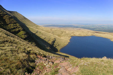
Llyn-y-Fan-Fawr & Mynydd Ddu from Llanddeusant
Brecon Beacons/Bannau Brycheiniog Walk
Nat Park - Brecon Beacons - Brecon Beacons West
County/Area - Carmarthenshire & Powys
Author - Nigel Armistead
Length - 12.0 miles / 19.5 km Ascent - 2000 feet / 606 metres
Time - 8 hours 0 minutes Grade - mod/hard
Maps 

| Ordnance Survey Explorer OL12 | Sheet Map | 1:25k | BUY |
| Anquet OS Explorer OL12 | Digital Map | 1:25k | BUY |
| Ordnance Survey Landranger 160 | Sheet Map | 1:50k | BUY |
| Anquet OS Landranger 160 | Digital Map | 1:50k | BUY |
Walk Route Description
Click image to see photo description.
Here's a brilliant trail, incorporating many good viewpoints and one extra-special one. It begins in Dyfed near the village of Llanddeusant and ends in Powys in the Glyntawe valley, crossing a mountain ridge that beats Pen-y-Fan in my view but because it's less accessible is less well-known. The following route is featured on the author's website Trails Less Trodden where he provides some wonderful detail on the views that can be enjoyed from many parts of Britain and further afield.
Head east from Llanddeusant and turn south up the Swaddle valley past old iron workings and lush grass featuring hollyhocks (or are they foxgloves?), marram grass, nettles, thistles - and lots of sheep. The stream itself tumbles down a gentle slope over moss-covered rocks. At the top of the valley, you come up to Llyn-y-Fan-Fach, an old Welsh Water reservoir no longer in use. It's situated in a somewhat severe and forbidding semi-circle of steep rock faces which form the western end of the ridge you will be climbing. On a sunny day, I expect it would be attractive, particularly on a summer's morning when the sun would shine into the cwm from the north-east. On my day, however, the clouds were still on the mountain-tops and the sun was hidden.
From the lake, there's a visible path to the west, heading up to the beginning of the ridge. Once up, you can enjoy good views over Llyn-y-Fan-Fach along the ridge and over the plain to the north-east, where the much larger Usk Reservoir can be seen.
The walk along the ridge is a nice up-and-down affair, with path construction in progress when I was there - I had to leave a note telling the path-builders that many of their steps were too high for people like me so we would by-pass them, thus defeating the object of the exercise.
The best view on the ridge is at Fan Foel towards the eastern end. This peak sticks out to the north of the ridge and affords good views in all directions, even to the south where rolling hills lead down towards the South Wales coast, just visible in the distance. As I surveyed the scene (and the map), I noticed how many 'Fans' there are around: Fan Foel, Fan Brycheiniog, Fan Gyhirich, Fan Fraith, Fan Llia, Fan Dringarth, Fan Fawr, Fan Frynych, Fan Nedd, Fan Hir, Pen-y-Fan, White Fan Man, Cardiff City Fan, Swansea City Fan ... Now the Welsh for hill is 'moel' and the Welsh for mountain is 'mynydd'. What, then, does 'fan' mean? From the map, it appears that all the peaks over 600m are 'Fans' and that those under 600m are 'Moels'; also that all the 'Fans' are within a small area of the Brecon Beacons National Park. So I concluded that 'Fan' must be the local word for mountain (such are the musings of a solitary walker).
After Fan Foel, it's a few minutes to the highest point on the ridge, Fan Brycheiniog, but the view from there is not so good. There is, however, a useful shelter if the weather cuts up rough and a view of Llyn-y-Fan-Fawr below. Instead of returning to Llandeusant as most guide books suggest, I recommend you follow the path to the south-east that descends the mountain-side by an attractive, newly-constructed path with views over the lake.
Just before you level out with the lake, there's a mossy rock that provides a welcome seat from which to survey a magnificent panorama. It's just the right height to sit on and at just the right elevation to view the lake at its best - in fact, it hits the spot in every way:
North-West - the escarpments of Fan Foel and Fan Brycheiniog rear up steeply
North - Llyn-y-Fan-Fawr shimmers on its shelf between the ridge and the countryside below; beyond the lake, are rolling hills around the Usk and Towy valleys
North-East - the Cray and Senni valleys wind down to Sennybridge
East - the twin table-top peaks of Pen-y-Fan and Corn Du preside over the Usk valley that stretches down to Brecon; between Pen-y-Fan and your seat is a series of minor Fans, six in all, aligned in a gentle curve; in the middle distance, the Tawe valley (Glyntawe) begins its journey to the coast at Swansea (Abertawe)
South - the slope of yet another Fan, Fan Hir, which is actually another ridge 4k long going down to Glyntawe
West - the path just descended
The view is wide-ranging, just as it was from the ridge, but you have the striking beauty of Llyn-y-Fan-Fawr in front of you to make it exceptional. You can also see a choice of routes ahead, one leading to Bwlch Carrig Duon, a pass from the Tawe valley to the Usk valley, the other, less obvious, down Nant-y-Llyn to the stone circle at Maen Mawr. The Tawe River in fact rises just below you, running east for a few kilometres before turning south. I took the path to the Bwlch and it was clear that this terrain would be very boggy in winter or in rainy weather so bear that in mind.
Just before the Bwlch, there are some mini-waterfalls and pools which provide a pleasant resting place and from which there's a great view back to Fans Foel and Brycheiniog. At the Bwlch, you can choose whether to head north towards Trecastle and the A40 or south down Glyntawe to the A4067. I went south and the first stretch of the valley is amidst lovely scenery on a road that slopes downhill just the right amount for easy walking. After meeting the A4067, however, things become rather tedious if you have to walk to Abercraf, as I did, for somewhere to stay - in the end I cadged a lift.
Other walks nearby
| Walk 3559 | Picws Du & Llyn y Fan Fach from near Llanddeusant | moderate | 5.3 miles |
| Walk 2194 | Mynydd y Llan & source of the Usk | easy/mod | 6.7 miles |
| Walk 3563 | Fan Brycheiniog and Picws Du | moderate | 7.1 miles |
| Walk 2645 | Fan Gyhirych & Fan Bwlch Chwyth, Fforest Fawr | moderate | 8.0 miles |
| Walk 2646 | Fan Nedd & Fan Bwlch Chwyth, Fforest Fawr | moderate | 7.0 miles |
| Walk 2647 | Fan Gyhirych, Fan Nedd & Fan Bwlch Chwyth | moderate | 10.0 miles |
| Walk 2643 | Fan Frynych & Fan Llia, Fforest Fawr | moderate | 8.0 miles |
| Walk 3205 | Carnau Gwynion from Ystradfellte | easy | 4.0 miles |
| Walk 3206 | Ystradfellte Waterfalls Walk | moderate | 9.2 miles |
| Walk 2641 | Fan Fawr & Fan Frynych, Fforest Fawr | moderate | 6.5 miles |
Recommended Books & eBooks
Walking on the Brecon Beacons
 45 circular day walks are described in this guidebook to the Brecon Beacons National Park. From west to east, Mynydd Du, Fforest Fawr, the Brecon Beacons and the Black Mountains these mountain and valley routes offer many options, highlighting the natural features. The walks described explore dramatic waterfalls, wooded gorges and upland valleys.
More information
Walking in Carmarthenshire
 Guidebook to 30 walking routes (2 to 10 miles) in Carmarthenshire, south Wales, including sections of Carmarthenshire Coast Path. Walks for all abilities, including coastal, river, forest and hill walks in Cambrian Mountains, Tywi Valley, Y Mynydd Du (Black Mountains) and Brecon Beacons. Easy access from Bristol, Cardiff and Swansea.
More information
Messaging & Social Media
Message Walking Britain and follow the latest news.

Mountain Weather
Stay safe on the mountains with detailed weather forecasts - for iOS devices or for Android devices.