Green Gable & Gillercomb Horseshoe from Seathwaite
Lake District Walk
Nat Park - Lake District - Lake District Western Fells
Wainwrights - Base Brown, Brandreth, Green Gable, Grey Knotts
County/Area - Cumbria
Author - Lou Johnson
Length - 5.5 miles / 8.9 km Ascent - 2600 feet / 788 metres
Time - 5 hours 20 minutes Grade - moderate
Maps 

| Ordnance Survey Explorer OL4 | Sheet Map | 1:25k | BUY |
| Anquet OS Explorer OL4 | Digital Map | 1:25k | BUY |
| Ordnance Survey Landranger 90 | Sheet Map | 1:50k | BUY |
| Anquet OS Landranger 90 | Digital Map | 1:50k | BUY |
Walk Route Description
Click image to see photo description.
This circuit of Gillercomb is an excellent Lake District walk. However it does include significant ascent for a route of this length. Following the ridges on either side of the valley the walk stays on the high ground and as such offers wonderful views throughout the walk. An extension to include Great Gable is easily added and a decision does not have to be made until you have reached the top of Green Gable. Navigation is generally easy apart from the first climb out of the valley which can easily be missed if you are in a hurry.
The start is Seathwaite in the upper reaches of Borrowdale where parking can be at a premium on fine days in high season. After walking continue south to the farm and continue through the archway on your right, along a walled lane to reach a footbridge over the River Derwent. Most of your fellow walkers will keep straight ahead and take the path alongside Sourmilk Gill. However our route turns right crossing a second footbridge to follow the river downstream. Go through the first wall heading towards the Borrowdale Yews. The first stream is Newhouse Gill and after crossing the stream turn left and follow the feint path on its north-eastern bank. This path was once used by the miners working the deposits of plumbago which was used in pencil manufacture in Keswick.
The path climbs up towards the first spoil tip, veering slightly left as you climb onto its top where there is a ruined building. The path zigzags higher past a second tip, climbing towards another tip with more ruined buildings. The path continues higher passing another ruin to reach a high intake wall with a ladder stile which leads you onto open hillside. The next section lacks a distinct path and you need to head for the skyline well to the right hand end of Raven Crag. Reaching a wire fence, follow the fence uphill to reach a stile. The summit of Grey Knotts is soon reached. You can now relax as about 1900 feet of ascent has been completed with just another 700 feet to go!
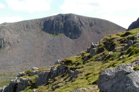
The path continues southwest passing a few small tarns to reach the summit of Brandreth. Green Gable and Great Gable now dominate your attention as you descend south passing another string of small tarns on Gillercomb Head. Ahead lies 450 feet of ascent to Green Gable's summit.
To continue the horseshoe, return towards Brandreth for just over 400 metres to some large boulders. Just before these a cairned path leads north-east along a broad ridge towards Base Brown. With the ascent now complete you can enjoy the view to Glaramara and the Scafells. Initially the descent northeast from Base Brown's summit is easy going. The path reaches a rocky section. Look out for a narrow and easily missed path going right. This leads to the top of a wide gully, which should be ignored as an easy descent. Instead cross the gully and keeping right you will locate an easier path. Initially the path heads towards Seathwaite but soon bars left under the Hanging Stone.
Continue the descent until you reach the main valley path. Turn right and descend the paved path which descends steeply at times alongside Sourmilk Gill into the valley below. At the foot of the Gill cross the stile, and then the footbridge over the River Derwent and back through the arch at Seathwaite Farm. It's now time for refreshments in the café!
Other walks nearby
| Walk 1065 | Haystacks | moderate | 5.5 miles |
| Walk 1112 | Great Gable | hard | 7.3 miles |
| Walk 1245 | Castle Crag & Grange | easy/mod | 6.0 miles |
| Walk 1175 | Combe Gill Circuit | moderate | 5.5 miles |
| Walk 3328 | Eagle Crag & Seargeant's Crag from Stonethwaite | moderate | 7.0 miles |
| Walk 3133 | Ullscarf and Watendlath from Stonethwaite | mod/hard | 10.0 miles |
| Walk 1693 | Grange & Watendlath from Rosthwaite | easy/mod | 7.6 miles |
| Walk 1444 | Great Gable (Borrowdale route) | hard | 12.0 miles |
| Walk 1153 | The High Stile Ridge | hard | 10.0 miles |
| Walk 1289 | Fleetwith Pike & Haystacks | moderate | 5.5 miles |
Recommended Books & eBooks
Hadrian's Wall Path
 Hadrians Wall Path guidebook to walk the 84 mile National Trail. Described in both directions, the main description is west to east between Bowness-on-Solway and Wallsend, Newcastle, with extensions to Maryport and South Shields. With extensive historical information related to this World Heritage site and separate 1:25,000 OS map booklet included.
More information
The Cumbria Way
 A guidebook to the 73 mile Cumbria Way, an easy long-distance walk though the heart of the Lake District National Park, from Ulverston in the south to Carlisle in the north, with good transport links to either end. The route is largely low-level but this guide offers alternative mountain days to climb some of the famous fells en route.
More information
Messaging & Social Media
Message Walking Britain and follow the latest news.

Mountain Weather
Stay safe on the mountains with detailed weather forecasts - for iOS devices or for Android devices.