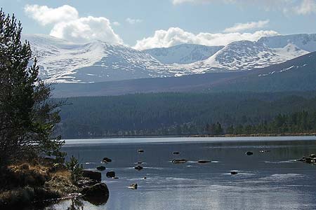
Ben Macdui & Cairn Lochan from the Ski Centre
Cairngorms Walk
Nat Park - Cairngorms - Cairngorm North
County/Area - Highland
Author - Andy Smith
Length - 10.4 miles / 16.9 km Ascent - 3000 feet / 909 metres
Time - 8 hours 10 minutes Grade - hard
Maps 

| Ordnance Survey Explorer OL57 | Sheet Map | 1:25k | BUY |
| Anquet OS Explorer OL57 | Digital Map | 1:25k | BUY |
| Ordnance Survey Landranger 36 | Sheet Map | 1:50k | BUY |
| Anquet OS Landranger 36 | Digital Map | 1:50k | BUY |
Walk Route Description
Click image to visit gallery of 4 images.
The Cairngorms offer some of the finest winter walking in Scotland with sub-zero temperatures and arctic storms; they give a real impression of how the country used to be long ago during the big freeze, along with some of the native wildlife such as the grouse and arctic white hare.
This high level walk has an added advantage of starting at altitude for those wishing to "bag the big ones" in shorter winter days, and takes in the second highest mountain in the British Isles, Ben Macdui.
From Aviemore take the B970 to Coylumbridge where you take unclassified road Glenmore. Passing Loch Morlich the road turns south before slowly winding uphill toward the ski centre (Grid ref. NH990060) where there is a large car park with plenty of parking. From there, walk under the start of the ski tows to the path leading away south into the hills. After a short while the path splits, bear right climbing steadily past Lurchers Crag and onto Miadan Creag.
Continue south with Cairn Lochan to your left; here even in summer the path seems non existent on these slow rolling summits and care is needed not to stray too close to the Lairig Ghru gully to the right. There now follows a steady 4km walk uphill to Ben Macdui, which is now in sight. Good navigational skills are a must here as the weather can break within minutes, immersing these high levels in dense cloud. However on a good day the views looking right across to Braeriach and Cairn Toul are breathtaking, especially during the winter. After a short steep climb, the grand summit of Ben Macdui is finally reached with superb views looking south into the Lairig Ghru with the river Dee over 2000ft below.
From the summit, head north retracing your footsteps toward Cairn Lochan. About half way along the path splits; take the right fork and head for the summit (Grid ref. NH984025). From the summit, the views across to Aviemore are stunning giving you the impression you can reach out and put it in your pocket! Continue east with the drop to your left. There is the option of a scramble down the small path of Fiacaill Buttress (for highly competent walkers), or as I did, follow the ridge round to the left over Fiacaill à Choire Chais taking in a good view of Cairn Gorm mountain itself. Keeping left of the ski tows, head downhill and drop down to the path just below the cairn. This will take you back to the ski centre and civilisation.
Other walks nearby
| Walk 2421 | Braeriach via the Chalamain Gap | hard | 15.0 miles |
| Walk 1605 | Loch an Eilein & Rothiemurchus Forest from Loch Morlich | easy/mod | 10.0 miles |
| Walk 2607 | Lairig Ghru & Chalamain Gap from Glenmore | mod/hard | 11.0 miles |
| Walk 3579 | Meall a'Bhuachaille & Ryvoan Bothy from Glenmore | moderate | 5.5 miles |
| Walk 3218 | Eag a' Chait gap Via Rothiemurchus Lodge from Glenmore | moderate | 8.2 miles |
| Walk 1020 | Glenmore to Linn of Dee via Lairig Ghru & Corrour | hard | 21.0 miles |
| Walk 2412 | Craiggowrie & Creagan Gorm from Loch Morlich | mod/hard | 7.3 miles |
| Walk 1904 | Loch Morlich circular (near Aviemore) | easy | 4.0 miles |
| Walk 1721 | Braeriach via Lairig Ghru | hard | 18.2 miles |
| Walk 3299 | Loch an Eilein from Coylumbridge | easy/mod | 7.0 miles |
Recommended Books & eBooks
Walking in Torridon
 This guidebook contains 52 day walks in Torridon, a remote and much-loved area of the Scottish Highlands. Based around Shieldaig and Slioch, the routes are split into 3 sections: easy walks, long and high level walks and mountain ascents over 2000ft including 9 Munros, and 5 outline suggestions for major ridge walks.
More information
Walking the Munros Vol 2 - Northern Highlands and the Cairngorms
 Guidebook to walking the northern Munros, covering the northern Highlands, the Cairngorms and the Isle of Skye. 70 routes are described, including those up Ben Macdui, Braeriach and Cairn Gorm. Routes range from 7 to 46km, requiring a fair level of fitness. The second of two guidebooks to walking Scotland's Munros: peaks higher than 3000ft.
More information
Messaging & Social Media
Message Walking Britain and follow the latest news.

Mountain Weather
Stay safe on the mountains with detailed weather forecasts - for iOS devices or for Android devices.