Plainfield to Wills Neck
Quantock Hills Walk
Region - Quantock Hills
County/Area - Somerset
Author - Philip Churchyard
Length - 5.0 miles / 8.1 km Ascent - 850 feet / 258 metres
Time - 3 hours 20 minutes Grade - easy
Maps 

| Ordnance Survey Explorer 140 | Sheet Map | 1:25k | BUY |
| Anquet OS Explorer 140 | Digital Map | 1:25k | BUY |
Walk Route Description
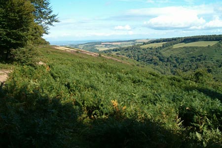
Click image to see photo description.
The start is the Forest Office car park at Plainsfield map reference ST188366. From the car park take the track on the south side up the ramp. The path climbs quite steeply until it reaches a clearing. Here, take the track in the north west corner of the field and keep climbing, steeply at first, and then more gradually as you pass the path to Cocker ombré Castle on your right (an Iron Age settlement with still visible earth banks). The path flattens at the top of the hill, and the trees clear where forest operations have felled the plantation in recent years. Follow the track round to the left as it drops gently towards the boundary wall.
Take the gate through the boundary and then turn immediately right and follow the track south west, gradually climbing again, with woodland on your right and Aisholt Common dropping away on your left. At Light Gate, where there is a confusion of paths, turn south and then south west and follow the stones track following the contour line to the north west corner of Bagborough Plantation, and then turn north west out onto the open moor to the tri point on top of Wills Neck, the highest point on the Quantock Hills with views all round.
Continue past the trig pint north west and then north , following the track down hill and through the gates to Triscombe Stone. Once at the Stone, cross the cattle grid into the car park and take the metalled road north and down hill for about 300 yards until there is a gate and footpath on the right. Follow this track steeply down until you reach a T junction, and then take the left hand path running north east, which becomes quite wide and well maintained, through Two Tree Bottom and into Cockercombe with plantation woodland on both sides. The track gently slopes down with a stream on your left for about 2 kilometres and back to the car park.
Other walks nearby
| Walk 1924 | Lydeard Hill to Wills Neck | easy | 2.6 miles |
| Walk 2330 | Quantock Hills from Dead Woman's Ditch | moderate | 9.2 miles |
| Walk 1822 | Hodder's Combe, Bicknoller Post & Higher Hare Knap | easy/mod | 5.8 miles |
| Walk 3211 | Crowcombe & Wills Neck | moderate | 7.3 miles |
| Walk 3412 | Dowsborough Fort from Holford | easy/mod | 6.0 miles |
| Walk 1696 | Weacombe Combe, Bicknoller Post, Kilve & Longstone Hill | easy/mod | 7.5 miles |
| Walk 1856 | Lilstock & East Quantox Head | easy/mod | 8.4 miles |
| Walk 2940 | Beacon Hill & Bicknoller Post from Kilve Beach | easy/mod | 7.0 miles |
| Walk 1973 | River Parrett from Pawlett | easy/mod | 7.1 miles |
| Walk 3570 | River Tone from Stoke St Gregory | easy | 5.2 miles |
Recommended Books & eBooks
No suggestions for this area.Messaging & Social Media
Message Walking Britain and follow the latest news.

Mountain Weather
Stay safe on the mountains with detailed weather forecasts - for iOS devices or for Android devices.