Ennerdale Skyline incl. Steeple & other fells
Lake District Walk
Nat Park - Lake District - Lake District Western Fells
Wainwrights - Caw Fell, Crag Fell, Grike, Haycock, Scoat Fell, Steeple
County/Area - Cumbria
Author - Jacinta Ashworth
Length - 13.8 miles / 22.3 km Ascent - 3800 feet / 1152 metres
Time - 10 hours 40 minutes Grade - mod/hard
Maps 

| Ordnance Survey Explorer OL4 | Sheet Map | 1:25k | BUY |
| Anquet OS Explorer OL4 | Digital Map | 1:25k | BUY |
| Ordnance Survey Landranger 89 | Sheet Map | 1:50k | BUY |
| Anquet OS Landranger 89 | Digital Map | 1:50k | BUY |
Walk Route Description
Click image to visit gallery of 5 images.
This is a lengthy Lake District walk that involves considerable ascent and total walking time will be approximately 8 or 9 hours. The start is the Forestry Commission Car park near the outflow weir at the western end of Ennerdale Water (Grid ref. NY085154).
Ennerdale is a quiet corner of the Lake District National Park for true connoisseurs. The valley is peaceful and secluded and Ennerdale Water is the only one of the larger lakes not to have a public road running along its shoreline. This long outing has a tough ascent to Steeple (or descent if you choose to walk the route in reverse) but the reward is a superb ridge walk along the southern skyline of the valley taking in the lesser known peaks of Haycock, Caw Fell and Iron Crag on route. Some clear paths and some unpathed fells that require good navigation skills especially in low cloud. The scenery is stunning, the hills are spectacular and the level of solitude ranks among the best in the Lake District National Park.
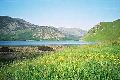
Begin at the car park at the western end of Ennerdale Water and walk up through trees to the weir. Turn East to follow the shoreline path around Angler's Crag. There's a little grass topped rock here called Robin Hood's Chair. Continue to follow the shoreline path. You are on the route of Wainwright's Coast to Coast path which starts at St. Bees and end at Robin Hood's Bay on the Yorkshire coast. Ennerdale Water, formerly known as Broadwater, had been a reservoir serving nearby Whitehaven for around 130 years. It's a glacial lake and its water is very pure with little vegetation or wildlife living in it. However it does accommodate trout, which makes it popular with fishermen. The path winds between roots of birch and oak trees with the lake on your left throughout. Eventually you enter the forest and the lake disappears from view.
A steep path turns south from the main track in the forest to climb straight up the ridge towards Steeple. It's a punishingly steep ascent but once you escape the treetops, the reward is a crow's nest view back over Ennerdale. The ridge narrows into the slender rib of grass, rock and rubble that forms Steeple. Again views of the valley are stunning from here, but equally impressive are those across the cliffs above Mirk Cove to Pillar.
A narrow neck of rock and grass links Steeple with Scoat Fell and then a broad ridge carries you ESE towards Haycock. An obvious path beside a wall leads to the summit of Haycock. It is another cracking viewpoint, with Ennerdale Water still in view leading the eye to the coastal plains of Cumbria. You'll also see all the remaining summits of the walk to the west. Leaving Haycock, follow the path west above the cliffs of Little Gowder Crag and along the ridge towards Caw Fell. The summit of Caw Fell is a broad, flat area (N.B. it's almost 1km west of the name Caw Fell on some OS maps). You can follow the wall once again as it crosses the head of Silvercove Beck and then turns North towards Iron Crag.
The path traces the wall and passes high above the cliffs of Iron Crag. Ahead Crag Fell can be seen and the route towards it leads over the grassy fell of Boathow Crag and then down to the edge of a plantation. A gate gives access to a forest track, which you follow to the left, then to the right and uphill to another track. Turn left here, then look for a cairn and a faint path on the right leading NW to a clearing. A stile carries you over the forest fence and open ground leads to the summit of Crag Fell.
To reach Grike turn SW to reach a stile, from where a path leads alongside the old mine road and then continues to the summit. A path leads N from the summit towards Ennerdale Water. The path becomes steeper on the lower slopes then reaches a gate and stile, where you turn left on a path which leads into the forest. Descend a firebreak to a track in the valley, where you turn right towards Crag Farm House. A gate on the left enables you to bypass the farm and return to the car park at the head of Ennerdale.
Other walks nearby
| Walk 3667 | Ennerdale Water Circular | moderate | 7.1 miles |
| Walk 1671 | Grike & Crag Fell | easy/mod | 6.6 miles |
| Walk 1082 | Ennerdale Horseshoe | severe | 18.0 miles |
| Walk 1745 | Grike and Caw Fell from Kinniside Stone Circle | mod/hard | 13.5 miles |
| Walk 1302 | Low Fell and Fellbarrow from Loweswater | easy/mod | 6.0 miles |
| Walk 3676 | Hen Comb from Loweswater | moderate | 5.4 miles |
| Walk 1290 | Mellbreak | moderate | 7.0 miles |
| Walk 2539 | Grasmoor and Rannerdale Knotts | moderate | 8.0 miles |
| Walk 1231 | Grasmoor via Whiteless Pike | moderate | 7.0 miles |
| Walk 2020 | Rannerdale Knotts and Crummock Water from Cinderdale Common | easy/mod | 2.5 miles |
Recommended Books & eBooks
Walking the Lake District Fells - Mardale and the Far East
 Part of the Walking the Lake District Fells series, this guidebook covers a wide range of routes to 36 Lakeland summits that can be climbed from the Ullswater, Haweswater, Troutbeck, Kentmere and Longsleddale valleys, with highlights including High Street, Place Fell and the Kentmere fells. Suggestions for longer ridge routes are also included.
More information
Great Mountain Days in the Lake District
 An inspirational guidebook to 50 challenging walks on the high fells of the Lake District. The graded circular routes, between 4 and 14 miles in length, cover classic Lakeland summits like Fairfield, Scafell Pike, Great Gable and Blencathra, to the lesser-known High Spy, King's How and Brund Fell.
More information
Messaging & Social Media
Message Walking Britain and follow the latest news.

Mountain Weather
Stay safe on the mountains with detailed weather forecasts - for iOS devices or for Android devices.