Leith Hill circular
Surrey Walk
County/Area - Surrey
Author - Barry Mackie
Length - 1.5 miles / 2.4 km Ascent - 185 feet / 56 metres
Time - 1 hours 0 minutes Grade - easy
Maps 

| Ordnance Survey Explorer 146 | Sheet Map | 1:25k | BUY |
| Anquet OS Explorer 146 | Digital Map | 1:25k | BUY |
| Ordnance Survey Landranger 187 | Sheet Map | 1:50k | BUY |
| Anquet OS Landranger 187 | Digital Map | 1:50k | BUY |
Walk Route Description
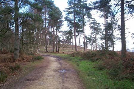
Click image to visit gallery of 6 images.
Is there really anywhere for a hill walker to go in the so called flatlands of south-eastern England? Well, if it's the height that matters most to you, then you're probably going to say no; especially as there's not a single top within this region that reaches the so- called national benchmark of 1000ft.
The following description includes a visit to the summit of Leith Hill and the gothic style tower that RH built. Be you a hill bagger, a walker or just someone who appreciates incredible panoramic views; a visit here to see for yourself how he addressed this perceived shortfall in height, will give you an opportunity to enjoy a wonderful place that has such a charming eccentricity about it.
This walk starts from the Starveall Corner car park (free parking) alongside the B2126 road at grid ref TQ130432. A simple and very direct route to the summit is clearly marked on wooden posts up a track through the woods and if you do take this, the popular day trippers and hill baggers option, then you can simply retrace your steps back to the car park by following these waymarkers. The route described here though, makes slightly more of a walk of it, by using some of the less direct footpaths on the hill, although they are all clearly marked on the OS Explorer map.
From the entrance of the car park, go south east along the road for approx 50 m to reach a section of the signed Greensand Way, which itself is part of a 108mile route that traverses much of the Greensand Ridge through Surrey and Kent. Turn left onto this wide track and follow the route, generally in an easterly direction, up the easy slope through the pine trees to come out at a clearing. This is the summit approach of Leith Hill and ahead of you, completely dominating the area is the 65ft high tower. Depending on when you visit, the tower may be open to visitors, allowing you the opportunity to climb the narrow internal stairway and reach its top. Do this if you can.
In recent years, the views from around the base of the tower were somewhat blocked by the density of trees in the immediate vicinity, but now they quite amazing in almost every direction. Of course, it gets better still if you climb the tower and use the fixed telescope at the top. On a clear day, look for the Sussex Weald, the South Downs, the English Channel and St Paul's Cathedral in London. Incredibly 13 counties can be seen from here. Oddly enough though, what may hold your attention the most, is the fascinating sight of watching aircraft slowly rising above the skyline far below you at the nearby Gatwick Airport.
To return to the car park, take the obvious path that heads to the North West and then veers west away from the tower and back into the woodlands. There are a few paths in this vicinity, but a left at the first and second forks and a right at the third, leads down the easy slope again in a north west direction to meet the path running north/south at grid ref TQ130436. Turn left here to soon return to the start point at the car park
How to get there
The easiest route is to take the A24 to the South of Dorking and then follow the A29. Turn right off the A29 at Ockley onto the B2126, and then follow signs for Leith Hill to reach the car park on your right
Notes
Ignoring the additional height of the tower, Leith Hill is the second highest hill in Southeast England. Walbury Hill in Berkshire is the highest at 974ft. A hill bagger is someone who "collects" hills by virtue of having stood on their summits. For these people, the walk up is merely a function of getting there and will often be the shortest and easiest route available. Leith Hill is very collectable to such enthusiasts, as it is both the county top (highest hill) in Surrey and also defined as a Marilyn (a hill with a 500ft drop on all sides).
Richard Hull's association and commitment to Leith Hill continues long after the building of the tower. On his death in 1772 he was buried beneath its base.
Leith Hill and the surrounding area is owned and managed by the National Trust. Opening days and times for the tower include - Every weekend throughout the year 10am - 3.30pm plus Fridays between the end of March to the end of October, with opening times for this summer period 10am-5pm.
Other walks nearby
| Walk 2124 | Leith Hill and Box Hill, two of the Surrey Hills | moderate | 12.5 miles |
| Walk 3610 | Ranmore Common Circular near Dorking | easy | 5.2 miles |
| Walk 1618 | The Box Hill Hike | mod/hard | 8.0 miles |
| Walk 1869 | Thorncombe Street from Bramley | easy/mod | 6.0 miles |
| Walk 3406 | The Wey & Arun Canal, Loxwood | easy | 4.5 miles |
| Walk 1447 | Tadworth Circular | easy/mod | 8.5 miles |
| Walk 2479 | Worth Way from Three Bridges, near Crawley | moderate | 14.0 miles |
| Walk 1048 | Ardingly Reservoir | easy/mod | 8.5 miles |
| Walk 2683 | Farthing Downs and Happy Valley from Coulsdon South | easy/mod | 6.0 miles |
| Walk 1953 | Balcombe & Ardingly Reservoir | easy/mod | 7.8 miles |
Recommended Books & eBooks
No suggestions for this area.Messaging & Social Media
Message Walking Britain and follow the latest news.

Mountain Weather
Stay safe on the mountains with detailed weather forecasts - for iOS devices or for Android devices.