Milford, Seven Springs, Little Haywood & Shugborough
Cannock Chase Walk
Region - Cannock Chase
County/Area - Staffordshire - Cannock Chase
Author - Lou Johnson
Length - 6.0 miles / 9.8 km Ascent - 400 feet / 121 metres
Time - 3 hours 20 minutes Grade - easy
Maps 

| Ordnance Survey Explorer 244 | Sheet Map | 1:25k | BUY |
| Anquet OS Explorer 244 | Digital Map | 1:25k | BUY |
| Ordnance Survey Landranger 127 | Sheet Map | 1:50k | BUY |
| Anquet OS Landranger 127 | Digital Map | 1:50k | BUY |
Walk Route Description
Click image to visit gallery of 6 images.
This pleasant route explores many of the features of the northern part of Cannock Chase. The route is similar to walk 2911 but has been shortened and rerouted at the end. Despite these changes the route offers an introduction to this part of Cannock Chase and is ideal for first time visitors to this part of England.
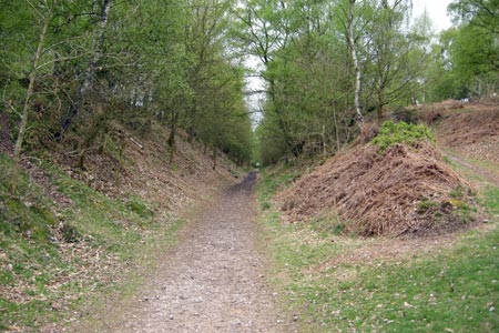
The start is the off road car park at grid ref. SJ973208. This is reached by turning off the A513 at Milford common and taking the road south to Brocton. After passing Sister Dora's rest home on the left, turn half left off the road onto a gravel track. You can park on the right in a few metres from the road. After parking continue along this gravel track soon entering a deep cutting. This was formerly a railway track that led up to the POW camp higher on Cannock Chase. As a child it was known as the German Cutting and this name survives today. Once through the cutting the main track continues and starts to bear right. At this point turn left down another gravel track. There is a signpost at the junction.
Follow this track until you reach the next junction (grid ref. SJ980202). Turn right and continue walking with a boundary fence on your left. Quite soon you reach some stepping stones on your left. You are now in the Sherbrook Valley with the stream of the same name. Cross the stream and follow the gravel path. This undulates a little and leads to a car parking area at Seven Springs. As a kid I tried to count all the springs but never reached seven! Bear left as soon as you reach this parking area and locate the gravel track leading north to the main road (A513).
Cross the main road with care and take the minor road opposite. This leads across an attractive bridge over the River Trent and onto the village of Little Haywood. Go under the railway (the West Coast main line from Euston to Glasgow) to reach a canal. The steps down to the towpath are on the right of the road and after dropping down to the canal you need to go under the bridge and follow the canal with the water on your right. Follow the Grand Union Canal to the first over-bridge. You will see the River Trent on your left and also the impressive frontage of Shugborough Hall across the river as you follow the canal.
Leave the canal and climb up to the track. Turn south to almost immediately cross the Essex Bridge over the River Trent (grid ref. SJ995225). Once across this bridge you are in Shugborough Park and using the Staffordshire Way. You have to pay to visit the House and Gardens but this route enables you to enjoy the park and the outside of the house. Keep straight ahead on a wide path. This leads to a tarmac road. Continue straight ahead passing the farm on your right and a visitor centre (with toilets) on your left. The road crosses the railway, bears sharply right and then left to reach the main A513.
Turn right along the main road. At the first track bear right and almost immediately take a clear footpath on the left. This keeps roughly parallel to the main road and leads eventually to a small car park in a quarry (grid ref. SJ983208). Go through the parking area to the main road. Cross with care into another parking area and bear left and then half right to leave the car park at a clear wide track with a boundary fence on your left. Follow this track slightly uphill before descending to a junction of tracks (grid ref. SJ980202). You have now rejoined the outward route. Keep right and then climb gently up to another track. Bear right and walk through the 'German Cutting' back to your transport.
Other walks nearby
| Walk 1802 | Shugborough Park from Milford | easy | 4.5 miles |
| Walk 1370 | Sherbrook Valley from Punch Bowl, Milford | easy | 4.0 miles |
| Walk 2023 | Cannock Chase War Trail | moderate | 7.5 miles |
| Walk 2199 | Brocton & Walton-on-the-Hill Circular | easy | 3.5 miles |
| Walk 1843 | Haywood Slade & Sherbrook from Seven Springs | easy | 4.0 miles |
| Walk 1753 | Abraham's Valley & Haywood Warren from Seven Springs | easy | 3.0 miles |
| Walk 2443 | Tixall from St Thomas Priory near Stafford | easy | 7.0 miles |
| Walk 1324 | Glacial Boulder & Sherbrook | easy | 3.5 miles |
| Walk 1413 | Sherbrook, Stepping Stones & Freda's Memorial | easy | 6.0 miles |
| Walk 1394 | Bednall & Acton Trussell from near Stafford | easy | 6.5 miles |
Recommended Books & eBooks
Walking in the Peak District - White Peak East
 Guidebook describing 42 half-day and day walks in the limestone landscapes of Derbyshire's White Peak, part of the Peak District National Park. One of two volumes, this book covers the east of the region, with potential bases including Bakewell, Eyam, Castleton, Birchover, Matlock and Wirksworth.
More information
Messaging & Social Media
Message Walking Britain and follow the latest news.

Mountain Weather
Stay safe on the mountains with detailed weather forecasts - for iOS devices or for Android devices.