Bristol Maritime Trail
Bristol Walk
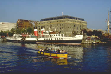
County/Area - Bristol
Author - Bristol Tourism & Conference Bureau
Length - 1.5 miles / 2.4 km
Ascent - nominal or unknown
Time - 0 hours 50 minutes Grade - easy
Maps 

| Ordnance Survey Explorer 155 | Sheet Map | 1:25k | BUY |
| Anquet OS Explorer 155 | Digital Map | 1:25k | BUY |
Walk Route Description
Click image to visit gallery of 2 images.
Bristol has been a port for centuries. The Anglo-Saxon Chronicle of 1051 mentions Bristol as a port trading with Ireland and the city's resourceful inhabitants have even changed the route of not one but two rivers and constructed a huge Floating Harbour to meet their needs. In the 18th century, Bristol's docks comprised the second largest port in the country. However, as ships became larger the tortuous River Avon became impossible to navigate and trade gravitated to Liverpool and the new docks at the Avon's mouth. Today the city's docks are mainly used for leisure and recreational activities but reminders of Bristol's maritime past can still be seen.
Start - On leaving St Nicholas Church (closed to the public) on St Nicholas Street, turn left down the steps and cross Baldwin Street to Bristol Bridge.
1. Look towards Castle Park. The park, built on the site of Bristol Castle, covers what was originally an Anglo-Saxon settlement almost circled by the rivers Avon and Frome. An early port was above the Bridge and trade was mainly with Ireland and, after the Norman Conquest, with France and Spain. This port became too small and the river was diverted through today's Centre and into St Augustine's Reach. The old port declined and a bridge was built with arches and houses on either side of the thoroughfare. Cross the bridge and descend the steps on the right.
2. Across the water is a beautiful building in the 'Bristol Byzantine' style, which was originally a granary. The dip in the harbour wall was caused by World War II bombing. Follow the walkway until reaching a blue spiral sculpture. Turn left into Ferry Street, then right. At the roundabout by St Mary Redcliffe Church, bear right. Cross road and turn into Redcliffe Wharf. Walk along the waterside.
3. On the left is the entrance to the Redcliffe Caves, (closed to the public). The caves were once storehouses, and the sand dug from the caves used for ballast, and in the manufacture of glass, another thriving industry in Bristol throughout the centuries. Redcliffe Parade has an interesting history (see plaque) and a donkey ramp can still be seen which was used to transport goods from the quayside. Blackbeard, the notorious pirate, was born in this area in the 17th century. Folklore has it that he was responsible for the deaths of over 2,000 people, and had 14 wives.
4. Continue along the waterside and turn left to walk around Bathurst Basin. The huge tides of the Avon had always caused problems to ships docking at Bristol. Ships would creak and groan at the ebb and flow and many timbers were damaged. But Bristol-built ships were very sturdy with everything tied down hence the saying, 'shipshape and Bristol fashion'. In the late 18th century the tidal problem had become acute, and William Jessop, a civil engineer was commissioned to create a Floating Harbour, allowing vessels to remain at a high water level. A weir and a dam were put across the Avon upstream, and a 2 mile 'New Cut' constructed to take the diverted river. Work began in 1804 and was completed in 1809, overseen by Jessop's son Josiah.
5. On reaching the main harbourside, turn left and continue. Cross over the Wapping Road to visit the Industrial Museum on the left. The museum is housed in the last transit sheds of the old city docks, containing many exhibits that portray Bristol's industrial past including a mock-up of Concorde's cockpit. It is in this part of the harbour that the Great Western steamship was built. Launched in 1837, she was the first of Brunel's passenger ships and plied between England and New York for 8 years. Continue along the waterside to the Maritime Heritage Centre.
6. The Maritime Heritage Centre documents a thousand years of shipbuilding in Bristol from sail to diesel. Next door is the ss Great Britain, the first iron, propellant-driven ship to cross the Atlantic. Designed by Brunel, and launched in 1843, this magnificent ship made voyages to New York and Australia and saw war service in the Crimea. Abandoned in the Falkland Islands, she became a store ship and just escaped being used by the Navy for target practice. She was brought back to Bristol and restored in 1970, and can be visited in her original dry dock.
7. Follow the sign to Bristol Marina, turning right at the alley and right on the railway tracks. The Marina used to be the Albion Yard, site of the Charles Hill and Sons shipyard where the largest ship, and the last ship to be launched in Bristol were constructed. Pick up the harbourside walkway to Baltic Wharf, once a series of timber wharfs which were linked with the Baltic ports in the summer months when the sea was free from ice. Look out for the docks dredger named after Samuel Plimsoll, famous for the Plimsoll Line, who was born in Bristol.
8. Continue along the waterside to The Cottage public house. Turn left at the Cottage Inn, right at Cumberland Road and follow the road to the right past some cottages into Nova Scotia Place. The lock here is the only original Jessop lock to survive. The huge red brick buildings used to be bonded warehouses for the storage of tobacco.
9. Retrace your steps and cross Merchant's Road swing bridge and turn right. The ferry to St Augustine's Reach, (operating only at weekends), can be picked up just past the Pump House pub which used to be an engine house for opening the swing bridge.
10. On the ferry journey, look out for Brandon Hill and the Cabot Tower on the skyline. The Tower was built in 1897 to commemorate Cabot's voyage to Newfoundland four hundred years earlier. A light at the top flashes out BRISTOL in morse code. The arena outside the Lloyds TSB 'Sun and Moon' building is today used for open-air concerts.
11. On leaving the ferry pause for a moment at Neptune's statue, to look along the Centre. The original 13th century harbour was sited here. Turn to walk down St Augustine's quay on the left hand side of the water. The buildings on the right across the harbour used to be transit shed and today house offices, shops, restaurants and the Watershed Media Centre.
12. At the far end of the quay, pass the statue of Cabot and the Arnolfini Arts Centre, a former tea warehouse. Turn left at the Arnolfini and cross the road to the Mud Dock, built to provide a soft berth for ships in the days before the Floating Harbour. Cross over the Grove and past the Roundabout and turn into Welsh Back noting the Hole in the Wall pub. This is supposedly the model for the Spyglass Inn from Treasure Island.
13. Welsh Back was a very busy part of the harbour, full of small coastal vessels carrying produce for the various markets of Bristol. Much trade was done with welsh traders that sailed down the Wye and Severn - hence the name Welsh Back. Some fine warehouses can be seen on the opposite side of the water. The Western Counties Agricultural Co-operative building dates from 1913 and is an early example of the use of reinforced concrete. The two red-brick buildings, originally a mill and a granary, are 19th century.
14. Pass the cannons, recovered from the Albion Dockyard, and return to St Nicholas Church.
Further information about walks can be obtained from Bristol Tourist Information Centre on 0117 926 0767 who are located at Wildscreen Walk, The Harbourside, Bristol (by the Explore-at-Bristol building)
Other walks nearby
| Walk 1518 | Brunel's masterpieces and the Avon Gorge | easy | 4.0 miles |
| Walk 1567 | Keynsham to Bath on the south side of the Avon | easy/mod | 11.1 miles |
| Walk 2426 | Wraxall circular from Tyntesfield | easy | 3.2 miles |
| Walk 3278 | Hinton & Dryham Circular | easy | 3.0 miles |
| Walk 2097 | Blagdon Lake | easy/mod | 5.7 miles |
| Walk 2804 | Bath to Keynsham over Kelston Round Hill | easy/mod | 9.0 miles |
| Walk 3437 | The Severn Estuary from Thornbury | easy/mod | 9.3 miles |
| Walk 3332 | Cameley & Hinton Blewett from Litton | easy | 5.6 miles |
| Walk 1891 | Solsbury Hill from Northend | easy | 3.0 miles |
| Walk 2087 | The Cam Brook Valley from Southstoke | easy | 5.5 miles |
Recommended Books & eBooks
No suggestions for this area.Messaging & Social Media
Message Walking Britain and follow the latest news.

Mountain Weather
Stay safe on the mountains with detailed weather forecasts - for iOS devices or for Android devices.