Ripon Rowel Walk Leg 1 - Ripon to South Stainley
North Yorkshire Walk
County/Area - North Yorkshire - Vale of York
Author - Phil Catterall
Length - 10.0 miles / 16.3 km Ascent - 770 feet / 233 metres
Time - 5 hours 50 minutes Grade - easy/mod
Maps 

| Ordnance Survey Explorer 299 | Sheet Map | 1:25k | BUY |
| Anquet OS Explorer 299 | Digital Map | 1:25k | BUY |
| Ordnance Survey Landranger 99 | Sheet Map | 1:50k | BUY |
| Anquet OS Landranger 99 | Digital Map | 1:50k | BUY |
Walk Route Description
Click image to visit gallery of 6 images.
A linear walk from Ripon on the first section of the circular 50 mile Ripon Rowel Walk, returning from South Stainley via the No. 36 bus. This first stage takes you along the banks of the Ripon Canal and the River Ure and through the villages of Bishop Monkton and Burton Leonard. The path is very well marked with the familiar Ripon Rowel logo - see photo (pictured).
If travelling by car a suggested car parking place is near North Bridge at SE319722. Alternatively there are fee paying long stay car parks in Ripon Town Centre. At the end of the walk at South Stainley the Harrogate-Ripon 36 bus will take you back to Ripon. There are three buses every hour on most days of the week.
You start your walk from North Bridge, making your way to the Minster and the official start point of the Ripon Rowel Walk. Cross the bridge taking the first left into Magdalen's Road. Continue straight on into Stonebridgegate and then St.Marys Gate and then turn left into Minster Road. Continue to the West front of the Minster. Take the path through the churchyard to an arch on your right. Turn left into a street with the Cathedral Hall on your left. Continue for 150m and then turn right into Agnesgate. This takes you to a footbridge across the River Skell at SE316709. Follow the riverside path for 300m and then make right to join the B6265 which runs alongside the Ripon Canal.
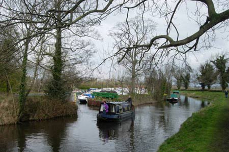
Join the canal towpath at the first opportunity so that you use the pedestrian underpass of the Ripon Bypass. The canal soon bears off right. It's good to get away from the traffic at last. The Ripon Canal is well used by pleasure boats allowing them to join the main inland waterways system via three locks over 2 miles leading into the River Ure. There is plenty of bird life along this section of canal. Ripon Racecourse runs to the east between the canal and the river and there are some lakes nearby. We sighted two mink along the towpath here (pictured). A large boating marina is also a feature at SE327693.
Follow the canal for 2 miles until the River Ure is reached at Oxclose Lock (pictured). Follow the Ure for half a mile and then take the path turning right away from the river. This path junction is easily missed as an unmapped path continues along the river bank. Boroughbridge Road is soon reached where you turn left. After 200m take the waymarked path across open fields, keeping to the left of the hedgerow. The path now follows a stream to the Ings Lane track which turns to the right. This takes you to the village of Bishop Monkton, an ideal place for a lunch stop with plenty of seats bordering the stream running through the village (pictured) as well as a pub, The Lamb and Flag.
Leave Bishop Monkton on the road heading south to the junction at SE328660. From here a track goes straight on and this soon becomes a path as you leave the habitation behind. Some height is now gained as you head towards the village of Burton Leonard (pictured) with its pretty village green. Go west up Station Road and cut across the green on your left as you climb the hill to turn left onto Scarah Lane. Follow this through onto Limekiln Lane which is also metalled, but soon becomes a rough track. A pleasant path runs to the left of the track, through the woods at SE323631 above Limekiln Lane, and arrives at the same point, the footbridge at SE323627. Continue for 200m where another track comes in from your left, turn right here onto Rakes Lane for half a mile. When a T junction is reached turn right. Follow this lane for one mile to reach the outskirts of South Stainley at St. Wilfred's Church. This is the start point of the 2nd leg of the Ripon Rowel Walk.
After another 400m The Red Lion Pub is reached and the A61. From here the No.36 bus will take you back to Ripon.
The second leg of this walk can be found here Walk 2404
Other walks nearby
| Walk 3528 | Fountains Abbey & Markenfield Hall | moderate | 8.7 miles |
| Walk 2405 | Ripon Rowel Walk Leg 3 - Sawley to Ilton | moderate | 11.0 miles |
| Walk 2404 | Ripon Rowel Walk Leg 2 - South Stainley to Sawley | easy/mod | 8.5 miles |
| Walk 2407 | Ripon Rowel Walk Leg 5 - Grewelthorpe to Ripon | moderate | 12.0 miles |
| Walk 1358 | Ripley & Knox circular | easy | 5.5 miles |
| Walk 3726 | Brimham Rocks Circular | easy | 4.7 miles |
| Walk 1095 | The Marton-cum-Grafton Eight | easy | 3.3 miles |
| Walk 1929 | River Ure & Nutwith Common from Masham | easy/mod | 6.6 miles |
| Walk 1078 | Hampsthwaite & Ripley Park | easy | 7.5 miles |
| Walk 2406 | Ripon Rowel Walk Leg 4 - Ilton to Grewelthorpe | moderate | 10.5 miles |
Recommended Books & eBooks
Trail and Fell Running in the Yorkshire Dales
 Guidebook to 40 of the best trail and fell runs in the Yorkshire Dales National Park. Ranging from 5 to 24 miles, the graded runs start from bases such as Ribblehead, Dent, Sedbergh, Malham and Grassington and take in the region's diverse delights, from castles and waterfalls to iconic mountains such as Whernside, Ingleborough and Pen Y Ghent.
More information
Messaging & Social Media
Message Walking Britain and follow the latest news.

Mountain Weather
Stay safe on the mountains with detailed weather forecasts - for iOS devices or for Android devices.