Braeriach via the Chalamain Gap
Cairngorms Walk
Nat Park - Cairngorms - Cairngorm North
County/Area - Highland
Author - Peter Smyly
Length - 15.0 miles / 24.4 km Ascent - 4250 feet / 1288 metres
Time - 11 hours 50 minutes Grade - hard
Maps 

| Ordnance Survey Explorer OL57 | Sheet Map | 1:25k | BUY |
| Anquet OS Explorer OL57 | Digital Map | 1:25k | BUY |
| Ordnance Survey Landranger 36 | Sheet Map | 1:50k | BUY |
| Anquet OS Landranger 36 | Digital Map | 1:50k | BUY |
Walk Route Description
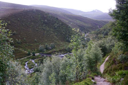
Click image to visit gallery of 6 images.
Although only featuring one Munro, this is a long and demanding walk for which at least several hours should be allowed. Further, at 4,252 feet, Braeriach is the third highest mountain in Scotland and the United Kingdom and only Ben Nevis and Ben Macdui stand higher. It is strongly advisable to get a detailed mountain weather forecast before setting out as even in summer, weather conditions can change quickly and be bitterly cold with blustery strong winds as well as hail, cloud and rain at higher altitudes in the Cairngorms.
Start at the Sugar Bowl Car Park, about a mile south east of Loch Morlich (grid reference NH9807) and cross the road. A footpath leads down through woodland to a footbridge that crosses a river, the Allt a' Choire Chais, before continuing up the slopes on the other side. The path soon emerges from the trees and levels out to maintain a clear course in a south to south westerly direction across terrain of heather and peat hags with the Chalamain Gap being the next objective. This objective can be seen from afar, looming ever larger as you approach it, provided that visibility permits. The landscape scenery at the entrance to the Chalamain Gap is somewhat reminiscent of the Rhinogs in Wales. Whether the rocks and boulders of the Chalamain Gap are found to be an enjoyable scramble or an awkward stretch to be negotiated, which you will be glad to have behind you, will depend on your own individual experiences and perception. My own view of it is the former, in dry weather conditions at least. Either way, it is an advantage to be tackling this potentially awkward section in the relatively early stages of the walk when legs are still fresh. Beyond the Chalamain Gap, the route descends to the valley of the Lairig Ghru, a great wide cleft that divides the highest mountains of the Cairngorms. Consequently, to walk up all five 4,000 feet plus peaks in one day would be a major expedition involving a considerable height loss which would later have to be regained across the great divide.
The path follows the left hand side of a stream and initially it appears that you need to find a way across it. However, a bit further along, it unexpectedly disappears underground and the path to the right up the hill is the way to go next. A steep slog up the felllside soon follows, but morale is likely to be restored once the top of this stretch is reached and the gradient eases off significantly making progress much easier up the next gentle slope towards Sron na Lairige, though there is a rocky section to be overcome. A fine view of the deep Lairig Ghru valley opens out on to the left. However, this is not a place to be in misty conditions as the lack of any clear identifiable landmarks, and similar-looking terrain in every direction on the immediate ridge, means that it is easy to become confused, therefore a compass or GPS is strongly recommended.
From the airy summit of Braeriach on the edge of Coire Brochain, reverse the outgoing route back down as far as the point where the path from the Chalamain Gap entered the Lairig Ghru. A variation in the route is suggested for the return from this point. Admittedly, this is a longer route back to the start point but it does mean that a) you are not faced with clambering over the rocks and boulders of the Chalamain Gap again and b) you get to see some different scenery by not merely reversing the whole of the outgoing route to the Chalamain Gap.
Continue on down the valley with the Allt Druidh river on your left along a clear path which turns right to go past the Rothiemurchus Lodge, just before which there is a pretty lochan on the right. Beyond the lodge, the path is indistinct in places as height needs to be gained up the side of a hill before, rounding the corner, you pass through a defile which is the other side of the Chalamain Gap and named as Eag a' Chait on the map. Care needs to be taken to avoid ankle-twisting rocks underfoot as the path follows a winding course. Once this section has been successfully negotiated, the path rejoins the outgoing path to the Chalamain Gap in the earlier part of the walk, the latter coming in from the right. Therefore, from a route-finding point of view, it is a simple matter of following that stage of the route in reverse back to the Sugar Bowl Car Park.
Other walks nearby
| Walk 1881 | Ben Macdui & Cairn Lochan from the Ski Centre | hard | 10.4 miles |
| Walk 2672 | Cairngorm Mountain via Coire an t-Sneachda | mod/hard | 6.0 miles |
| Walk 1390 | Cairn Lochan via the Fiacaill Buttress from Ski Centre | very hard | 5.7 miles |
| Walk 1276 | Loch Avon Circular via Cairn Gorm Mountain | hard | 9.0 miles |
| Walk 2314 | Cairngorm & Ben Macdui from the ski centre | hard | 11.0 miles |
| Walk 1605 | Loch an Eilein & Rothiemurchus Forest from Loch Morlich | easy/mod | 10.0 miles |
| Walk 2607 | Lairig Ghru & Chalamain Gap from Glenmore | mod/hard | 11.0 miles |
| Walk 3579 | Meall a'Bhuachaille & Ryvoan Bothy from Glenmore | moderate | 5.5 miles |
| Walk 3218 | Eag a' Chait gap Via Rothiemurchus Lodge from Glenmore | moderate | 8.2 miles |
| Walk 1020 | Glenmore to Linn of Dee via Lairig Ghru & Corrour | hard | 21.0 miles |
Recommended Books & eBooks
Walking in Torridon
 This guidebook contains 52 day walks in Torridon, a remote and much-loved area of the Scottish Highlands. Based around Shieldaig and Slioch, the routes are split into 3 sections: easy walks, long and high level walks and mountain ascents over 2000ft including 9 Munros, and 5 outline suggestions for major ridge walks.
More information
Skye's Cuillin Ridge Traverse
 This 2-volume set provides all the information required to complete the main ridge traverse on Skye's Black Cuillin. Strategy, gear, training, navigation and logistics are covered, and 10 classic scrambles are described. A lightweight second guidebook gives the scrambler detailed maps, topos and route description for the ridge traverse itself.
More information
Messaging & Social Media
Message Walking Britain and follow the latest news.

Mountain Weather
Stay safe on the mountains with detailed weather forecasts - for iOS devices or for Android devices.