Druid Circle, Moelfre and Foel Lus from Penmaenmawr
Snowdonia/Eryri Walk
Nat Park - Snowdonia - Eastern Carneddu
County/Area - Conwy
Author - Paul Gasson
Length - 6.0 miles / 9.8 km Ascent - 1590 feet / 482 metres
Time - 4 hours 40 minutes Grade - easy/mod
Maps 

| Ordnance Survey Explorer OL17 | Sheet Map | 1:25k | BUY |
| Anquet OS Explorer OL17 | Digital Map | 1:25k | BUY |
| Ordnance Survey Landranger 115 | Sheet Map | 1:50k | BUY |
| Anquet OS Landranger 115 | Digital Map | 1:50k | BUY |
Walk Route Description
Click image to visit gallery of 6 images.
This walk climbs the steep escarpment behind Penmaenmawr into the tail end of the Carneddau, and in doing so takes the walker back 5000 years in time. Generally clear paths but cloud drops suddenly, and the area around Moelfre can then be confusing, requiring good navigational skills. A good walk for families, but dogs will need to be kept on leads all the way.
The start - Take the old A55 road through the centre of Penmaenmawr, and, if arriving from the Chester direction, turn left at the traffic lights in the village centre. The car park is almost immediately on your right. Take time to admire the magnificent display of hanging baskets on the balconies of the block of flats overlooking the car park.
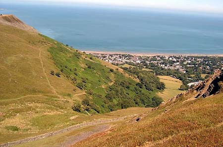
Turn right out of the car park, then immediately right again (Y Berllan). At the top of the rise Y Berllan turns sharply left. Follow it and take the first road on the right to a T junction. The crossing road reduces to a tarmac path a few feet to your left, and there is also an unmetalled pathway here. Follow the tarmac path, and, where it turns sharp right, continue straight ahead into a field with no sign of a path. Head straight across the field to a large Sycamore tree, and discover a kiss gate onto Graig Lwyd Road just beyond it. Turn left on the road, and in a few metres, turn right into Graig Lwyd Farm Holiday Cottages. Pass up the left side of the buildings and through a gate onto a clear path climbing steadily up through the trees. There are good views of the Great Orme, Puffin Island and Anglesey as you climb up this path, and there are a couple of wooden seats where the views can be savoured.
The hill to your right is in fact an extinct volcano, the top of which is a quarry, but in Neolithic times the top of the hill was the third largest Neolithic Axe Factory in the country, and remnants of axes and hammerstones can still occasionally be found on the hillside, as can the remains of some hut circles. The axes were quarried here and polished elsewhere before being exported throughout Britain and into Ireland, where there was an exchange of axe heads for gold, through what is now the port of Holyhead. Leaving the trees the path continues onto the open hillside, taking a left turn across a marshy area to gain the mountain wall at a gate. The marsh has been provided with a concrete walkway and steel handrail to enable a dry feet crossing!
Turn right through the gateway and follow the drystone wall for a few metres to join an obvious trackway at a waymark post. This is the fairly new North Wales Path running from Port Penrhyn near Bangor to Prestatyn and well waymarked throughout its length.
Turn left on the path and follow it for a few metres until a small stream comes down from a narrow gulley on your right. Leave the path here and climb up the right hand side of the gulley to the top of the rise, where the Druid Circle appears a few metres ahead of you. This stone circle predates the Druids and is in fact Neolithic and dating back to perhaps 3000BC. One of the stones has an obvious ledge on it and is known as the Stone of Sacrifice, though a legend states that if a baby less than a month old is laid on the ledge briefly it will have permanent good luck! Another stone is badly shattered and tradition has it that it was once dragged away from the circle and rolled down the hillside you have just climbed up, where it shattered, only to be miraculously restored to its position by the following morning. The whole situation of this Circle is imposing, on a broad plateau of wild moorland with the long bulk of Tal y Fan rising beyond and you can easily imagine yourself miles from civilisation here!
A narrow path leaves the circle about half right, and crosses a low mound to reveal another, smaller stone circle in poor condition, and, perhaps a 100 metres or so further on, what appears to be the remains of a round house. In fact the whole of this plateau between the Carneddau and the sea is richly endowed with Neolithic remains, and there are at least 20 of them in the immediate area.
After savouring the sometimes eerie atmosphere of these remains continue along the narrow path to a small stone cairn on the skyline of a broad grassy ridge. Turn right here and follow the ridge to the summit of a low hill known as Moelfre, which is a superb viewpoint for the Carneddau, the Menai Straits and Anglesey, and also NE towards Conwy Mountain. At one time the summit of Moelfre was adorned by three different coloured stones, which tradition has it were 3 local girls turned to stone for winnowing corn on the breezy summit on a Sunday. Unfortunately the stones were apparently vandalised several hundred years ago and rolled down the steep hillside where presumably they still remain amongst the gorse!
Retrace your steps to where Moelfre rises from the broad ridge, then turn left on a clear path to regain the North Wales Path a little to the West of where you first met it. Follow it right, rising up to a low ridge where a path cuts sharply back towards the Druid Circle. Close to this point on your right is a small circle of 5 stones, referred to unromantically by archaeologists as Circle 275! Continue along the North Wales Path until it drops down to join an unmetalled lane at a row of Scots Pines, and the house known as Bryn Derwydd ( Druid Hill).
Turn left and follow the lane past a standing stone on the right, known as Maen Crwn ( The round stone) and through 2 gates. The North Wales Path forks off right just before the second gate but we stay on the lane which turns North towards the hill known as Foel Lus, and joins another track from the farmstead of Ty'n y Ffrith (House of the Mountain Pasture). This would have been a 'hafod' where farmers looked after their flocks during the summer on the high land before returning to the 'hendref' in the valley for the winter.
Just after the two tracks meet up, another track branches off to the right. Take this track which passes above two isolated houses, Ffridd y Foel and Bwthyn Llwyd, and then reduces to a clear stony footpath. Follow this down the hill to join an almost level path, and take the left hand fork. This is the Jubilee Walk, constructed to mark Queen Victoria's jubilee and it continues, almost level, around Foel Lus, which falls steeply away to your right, giving more magnificent views, particularly so up the Sychnant Pass to the NE and Conwy Mountain with its Iron Age hilltop fort.
Follow the Jubilee Path to where it meets a tarmac lane at two large pillars, and follow the narrow lane steeply downhill until a public footpath leads off to your left through a kiss gate and runs alongside a line of trees, passing a small reservoir. Just beyond the reservoir the path turns sharp right and drops down past the reservoir to join a tarmac service road. Follow this downhill to join Graig Lwyd Road again, turning left then immediately right down a footpath, at the end of which is the tarmac road we set off on. Turn right onto this, then left, then right again to return to the car park.
Other walks nearby
| Walk 1435 | Sychnant Pass, Alltwen, Penmaen-Bach, & Conwy Mountain | easy/mod | 3.0 miles |
| Walk 3604 | Foel Lus & Jubilee Path from Sychnant Pass | easy/mod | 5.9 miles |
| Walk 2547 | Carnedd Llewelyn from near Rowen | mod/hard | 12.0 miles |
| Walk 3061 | Eastern Carneddau from near Rowen | mod/hard | 10.5 miles |
| Walk 2346 | Yr Orsedd ridge from near Bont Newydd | moderate | 4.8 miles |
| Walk 3020 | Aber Falls, Foel-fras & Drum | mod/hard | 9.0 miles |
| Walk 3021 | Northern Carneddau | mod/hard | 12.0 miles |
| Walk 1915 | Great Orme & Country Park from Llandudno | easy/mod | 7.0 miles |
| Walk 2072 | Great Orme & Country Park, Llandudno (short route) | easy/mod | 4.0 miles |
| Walk 1635 | Garnedd Uchaf & Llyn Eigiau | mod/hard | 9.0 miles |
Recommended Books & eBooks
Snowdonia: 30 Low-level and easy walks - South
 Guidebook describing 30 walks in Snowdonia, Wales. Routes are mostly low level and on clear paths and showcase the region's beautiful scenery and rich history and culture. Part of a 2-volume set, this southern volume includes Trawsfynydd, Bala, Dolgellau, Machynlleth, the Harlech Coast and the valleys of the Mawddach and Dyfi.
More information
Great Mountain Days in Snowdonia
 Inspirational guidebook to 40 great mountain day walks and scrambles in Snowdonia. Inspirational routes for all abilities across the National Park with routes up Snowdon and Moel Eilio, the Glyderau, the Carneddau, Eifionydd, Siabod and the Moelwynion, Rhinogydd (the Harlech Dome), Migneint and the Arans and Cadair Idris and the Tarrens.
More information
Messaging & Social Media
Message Walking Britain and follow the latest news.

Mountain Weather
Stay safe on the mountains with detailed weather forecasts - for iOS devices or for Android devices.