South Head & Edale Cross from Hayfield
Peak District Walk
Nat Park - Peak District - Kinder Scout Edale
County/Area - Derbyshire
Author - Mike Bexley
Length - 8.0 miles / 13 km Ascent - 1520 feet / 461 metres
Time - 5 hours 30 minutes Grade - moderate
Maps 

| Ordnance Survey Explorer OL1 | Sheet Map | 1:25k | BUY |
| Anquet OS Explorer OL1 | Digital Map | 1:25k | BUY |
| Ordnance Survey Landranger 110 | Sheet Map | 1:50k | BUY |
| Anquet OS Landranger 110 | Digital Map | 1:50k | BUY |
Walk Route Description
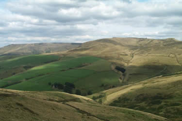
Click image to visit gallery of 3 images.
This Peak District walk visits the more remote areas to the east of Hayfield, includes good views and a safe crossing over the moors. The walk can be extended to include the Kinder Edges. The start is in the Hayfield Car Park (grid ref. SK036869) where a fee is payable. Leave the car park and take the steps which lead you under the by-pass. You will pass the Kinder Mountain Rescue Teams Hut on left. Go straight on to the road in front of The George Hotel.
Turn right on this road then first left only to bear to the right up Highgate Road, which is marked and named on the OS 1:25000 map. Keep on this narrow road as it climbs steadily providing views to the left of Kinder and the Downfall. Soon after passing a footpath sign on the left take the green path straight on. This joins a bridleway. Continue along this bridleway between stone walls until you reach the gate at its end. Go through the gate with Mount Famine on you left and continue straight on up the field following the footpath. You will then come to a further gate and a sign stating natural details of the area.
Keep straight on. The hill on you right is South Head which is worth the climb as it offers good views. and it is worth climbing for the views, although take care that you don't go too far over and miss your turning. Just at the highest point on this path there is a footpath sign to your left, take the unsigned footpath straight on - not the bridleway that heads right.
This pleasant path crosses the moor with further views of Kinder and in the valley the source of the River Sett. You will not get lost if you keep the fence close to you right. Away to your right is Brown Knoll, the summit of which is ignored by the path as it turns north to reach a bridleway. Turning right takes you to Edale via Jacob's Ladder while the path going straight on takes you up on to Kinder passing Edale Rocks on the way.
We are turning left onto the bridleway, which climbs up before descending to pass Edale Cross on your right. This cross was first erected by the Cistercian Abbots of Besingweal Abbey, Holywell, North Wales to mark the boundary of the land they owned. Stay on the bridleway which descends and exits onto a road. Keeping straight on, the River Sett tumbles its way down and you cross it at several points until you and the Sett reach the River Kinder. Stay on the road to the bridge where there are some public toilets. Do not cross over the bridge but take the road to the camp site passing to the right of the camp site entrance building. Follow this footpath with the river on your right to reach a road and the centre of Hayfield.
Other walks nearby
| Walk 1174 | Kinder Low & Mount Famine | moderate | 7.5 miles |
| Walk 1182 | Kinder Downfall | moderate | 8.0 miles |
| Walk 2546 | Lantern Pike & Cown Edge from Rowarth | easy/mod | 8.0 miles |
| Walk 1486 | Harry Hut, Mill Hill & Doctor's Gate from Glossop | moderate | 11.3 miles |
| Walk 3407 | Chinley to Edale without a car | moderate | 9.3 miles |
| Walk 2622 | Sett Valley & Kinder from New Mills | moderate | 10.0 miles |
| Walk 1923 | Cown Edge & Whiteley Nab from Chunal | easy/mod | 6.5 miles |
| Walk 2534 | Chinley Churn & South Head | easy/mod | 7.5 miles |
| Walk 2523 | Black Rocks & Bollinhurst Reservoir | easy | 5.0 miles |
| Walk 2567 | Lyme Park & Dissop Head | easy | 6.0 miles |
Recommended Books & eBooks
Great Mountain Days in the Pennines
 An inspirational guidebook to 50 classic walks on the rolling Pennine landscape. The graded routes, between 6 and 13 miles in length, cover classic Pennine fells and moorland such as Whernside, Ilkley Moor and Pendle Hill; exploring the North and South Pennines, Yorkshire Dales, Howgills and Dark Peak. Many routes are also suited to fell running.
More information
Dark Peak Walks
 Guidebook to 40 walks in the Dark Peak area of the Peak District National Park. 35 circular routes for most abilities, from 8km to 19km, around Edale, Marsden, Fairholmes, Baslow and Castleton, including Kinder Scout and Mam Tor, and 5 longer (25km to 45km) routes highlighting the best of the Gritstone Edges, High Moorland and Deep Valleys.
More information
Messaging & Social Media
Message Walking Britain and follow the latest news.

Mountain Weather
Stay safe on the mountains with detailed weather forecasts - for iOS devices or for Android devices.