Totridge Fell & Fiendsdale Head, Forest of Bowland
Forest of Bowland Walk
Region - Forest of Bowland
County/Area - Lancashire
Author - Mike Bexley
Length - 11.0 miles / 17.9 km Ascent - 1700 feet / 515 metres
Time - 7 hours 10 minutes Grade - moderate
Maps 

| Ordnance Survey Explorer OL41 | Sheet Map | 1:25k | BUY |
| Anquet OS Explorer OL41 | Digital Map | 1:25k | BUY |
| Ordnance Survey Landranger 103 | Sheet Map | 1:50k | BUY |
| Anquet OS Landranger 103 | Digital Map | 1:50k | BUY |
Walk Route Description
Click image to see photo description.
A very interesting walk if you are drawn by the solitude of the fells. Early on there is a long climb up onto the fells followed by a couple of hours traverse prior to dropping down through a secluded picturesque valley and water meadows back to your start.
Although I class this walk as moderate, if wet conditions prevail, then the walk can become hard going. I would advise you not to attempt the route if the fells are in mist or low cloud. Owners of a GPS will find its use a distinct advantage and accurate grid references are provided for this purpose.
Starting from a small lay-by at the foot of the Trough of Bowland Road near Dunsop Bridge (Grid ref. SD645506), cross the bridge over Langden Brook and walk up to Hareden Farm. Take the clearly indicated footpath on the left. Climb up the hill with the field boundary on your left, then over a stile onto a bridleway. Keep to this short bridleway with the woods on your left to a field. The path becomes very feint and at times non-existent so head slightly right up hill to the wall with a gate and stile (Grid ref SD 6435 4970). If you reach the corner of the field trace the wall back to the stile.
This stile is the start of a concessionary or permitted path that climbs up to the top of the fells. Head for a post or stake near a wall on the low left hand skyline by keeping close to the left wall and fence then over a stile. On reaching this post head up hill to a further post, then at this post bear right then left to follow a wide grass path that swings left then right to a post near the top. Stop and rest to admire the view prior to heading for the next post just further up the hill. Ahead of you is the vast expanse of the fells. Proceed slightly left through a shallow depression in the peat then keeping the same direction to the white painted trig point (Grid ref SD 6345 4870) that marks the summit of Totridge Fell. Leave the trig point and head in the same direction to the wall and fence.
This fence is your guide across the fells. If you are tempted to stride over it for a better path, do not loose sight of it and remember which side of it you are on, ideally the right hand side. When the fence turns sharp left on Whitmore Fell, continue ahead following a feint path to join the fence again. From now on keep as close to the fence as you can, not always possible due to many deep wet areas. Ignore the many access signs and notice boards with stiles. On reaching the first right hand corner (Grid ref SD 6235 4745) turn right to follow the fence to the second right hand corner near a cairn (Grid ref SD 5977 4725). Again turn right. The next stile and five bar gate with a fence disappearing over the fells to your right is not shown on the maps. Cross over this stile and continue to follow the fence ahead until you reach Fiendsdale Head (Grid ref SD 5885 4845). The access notice board is numbered 'two'.
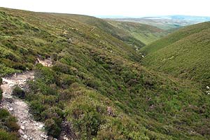
Your traverse across the fells is now over and I guess you do not want to see a fence again for some time! Turn right heading north. At first there is very little to indicate a path just a few bits of wood across damp ground but then a narrow path develops, confirmed by a post, that descends hugging the left hand side of the lovely Fiendsdale Valley. On reaching the bottom of the valley cross the Langden Brook, which can be a challenge if it is swollen.
Then turn right downstream to follow a clear path, with bridges over damp areas, descending to a very low small building, now used by sheep, called Langden Castle (Grid ref. SD 6060 5028). Folklore states this was an overnight stop for prisoners on their way to the Lancaster Courts and the name suggests a well-defended building with its own garrison.
The path now becomes a wide bridleway following Langden Brook down to the water works at the foot of the valley. Continue through the gate passing the buildings and down the tarmac drive turning right at the stile near the end of the wood. Cross over the bridge then over the stile, at first left to clear the damp ground, then right with the Brook on your left. At the end the field go over the stile near the water (there is just sufficient space between the water and the wall) then over the stile on the right into a small field. Cross over the small bridge in the middle of the field then through the five bar gate. Turn left back to the bridge and your start.
Other walks nearby
| Walk 1218 | Fiensdale Head & Bleasdale Water | moderate | 10.0 miles |
| Walk 3505 | Whitewell via Crag Stones from Dunsop Bridge | easy/mod | 8.5 miles |
| Walk 2508 | Dunsop Fell & the Forest of Bowland | moderate | 10.0 miles |
| Walk 2510 | Totridge Fell via Langden & Bleadale Water | mod/hard | 10.0 miles |
| Walk 2555 | Whitendale from Dunsop Bridge | moderate | 8.0 miles |
| Walk 2556 | Whitendale & Dunsop Fell from Dunsop Bridge | mod/hard | 15.0 miles |
| Walk 2331 | Whin Fell & Ouster Rake from Dunsop Bridge | moderate | 8.3 miles |
| Walk 2384 | Hodder Valley from Whitewell | easy/mod | 6.8 miles |
| Walk 3038 | Wolfhole Crag from Tower Lodge | moderate | 9.0 miles |
| Walk 2216 | Slaidburn Village Trail - Ribble Valley | easy | 0.8 miles |
Recommended Books & eBooks
Walking in the Forest of Bowland and Pendle
 A guidebook to 40 diverse circular day walks suitable for walkers with navigational skills. The Forest of Bowland and Pendle are two of north west England's upland AONBs, perfect for walkers who enjoy exploring rough hilly, sometimes pathless terrain. The routes include Ward's Stone, Pendle Hill, Longridge Fell and Fair Snape Fell.
More information
Walking on the West Pennine Moors
 This guidebook describes 30 walks on the West Pennine Moors, around Blackburn, Darwen, Chorley and Bolton, home to some of the most inspiring and exhilarating walking country. The walks range from short, easy rambles to more challenging hikes covering a variety of terrain, all of it easily accessible for day walking.
More information
Messaging & Social Media
Message Walking Britain and follow the latest news.

Mountain Weather
Stay safe on the mountains with detailed weather forecasts - for iOS devices or for Android devices.