Chew Reservoir & the Pennine Way
South Pennines Walk
Nat Park - Peak District - Black Hill Dovestone
Region - South Pennines
County/Area - Greater Manchester
Author - Peter Schofield
Length - 14.0 miles / 22.8 km Ascent - 2500 feet / 758 metres
Time - 9 hours 30 minutes Grade - mod/hard
Maps 

| Ordnance Survey Explorer OL1 | Sheet Map | 1:25k | BUY |
| Anquet OS Explorer OL1 | Digital Map | 1:25k | BUY |
| Ordnance Survey Landranger 110 | Sheet Map | 1:50k | BUY |
| Anquet OS Landranger 110 | Digital Map | 1:50k | BUY |
Walk Route Description
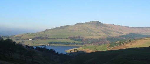
Click image to visit gallery of 4 images.
Using excellent public transport links, this linear Peak District walk provides the opportunity for those without their own cars to experience some of the fine sections of the Dark Peak around Black Hill and Laddow Rocks.
The walk starts at Greenfield Station (Grid ref. SD992046). On leaving the station, turn right and follow the road downhill around a sharp left hand bend. Continue for about 300m and turn right into Green Bridge Lane. Turn right to cross the bridge over Chew Brook (the first of several encounters with it) and then immediately left along a path through a housing development to reach the A635.
Cross over the road, go left for 50m, and turn right past a house, over a stile and head up the hill. At this point, things turn more promising. The urban sprawl of Greenfield is left behind and Alphin Pike lies ahead with a promise of finer things to come.
Follow the boundary wall up the hill for about 500m until a stile is reached. Cross over the wall and another one and pass through the garden of a private house to emerge at a junction of two tracks. Take the upper track. This is Intake Lane which was the route of the tramway which carried the stone used in the construction of Chew Reservoir from a quarry in Mossley.
The walk now follows a very pleasant route through woods and fields for 2.5 km. Extensive views open out over Dovestone and the Saddleworth edges and Alderman Hill and the Pots and Pans monument are visible across the valley. Chew Brook comes up to meet the path at a fine footbridge built on the abutments of the old tramway crossing where an information board tells something of the fascinating history of the operation of the tramway.
Cross over the bridge, climb up to the water company access road and follow it up the ever narrowing valley to Chew Reservoir. Walk along the south side of the reservoir and at the far end, continue along a well defined path which follows some of the streams feeding the reservoir. The desolate terrain of Black Chew Head lies to the north and further away, the Holme Moss transmitter can clearly be seen.
The streams are finally left behind and the boundary fence at Laddow Moss is reached. On a fine day, a magnificent Peak panorama opens up, Bleaklow, Kinder and Shutlingsloe all dominating the skyline to the south. The path continues down hill and after 300m, another superb vista unfurls itself as the Pennine Way is reached at Laddow Rocks (Grid ref. 056013).
Turn left on to the Pennine Way which is followed to Black Hill and then on to Wessenden Head. This section is well known to most walkers and little needs to be added; all I would say is enjoy an area which to me has a unique beauty all of its own.
On reaching Wessenden Head (Grid ref. 075072) turn right along the A635 and immediately left on to the Meltham road. After 300m, turn left down a broad track which is followed all the way to Marsden, passing four reservoirs en route. The track finally becomes a road as the edge of Marsden is reached. At the roundabout at the bottom, continue straight on and go under a bridge beneath the A62 road. With the parish church on your left, continue for 200m to a road junction. Bear left a further 200m up Station Road to Marsden station from where a train will take you back to the start at Greenfield at the end of a magnificent day's walking.
Both trains and buses (First 184) provide hourly journeys between Marsden and Greenfield on weekdays. On Sundays, there are no trains but the 184 operates at a two hourly frequency. Full details can be found on the Metro website (www.wymetro.com).
Finally, if you've just missed your train or bus, Marsden's own brewpub The Riverhead Brewery offers a most relaxing way of passing an hour (or maybe two) until the next one. A walker friendly place, it's situated in the centre of the village 200m from where you reach Station Road. Just turn right rather than left at that point cross over the bridge and it's right in front of you!
Other walks nearby
| Walk 2914 | The Pots & Pans from Uppermill | easy/mod | 4.5 miles |
| Walk 2517 | Chew Reservoir & Fox Stone from Dovestones | moderate | 7.5 miles |
| Walk 2553 | Greenfield Reservoir & Raven Stones from Dovestone | moderate | 8.0 miles |
| Walk 2634 | Broadstone Hill & the Cotton Famine Road | moderate | 7.0 miles |
| Walk 2521 | Hollingworthall Moor & Walkerwood Reservoirs | moderate | 7.0 miles |
| Walk 3607 | Reservoirs Walk from Tintwistle | easy/mod | 5.5 miles |
| Walk 2613 | Boundary Walk from Marsden | moderate | 13.0 miles |
| Walk 2518 | Black Hill & Four Reservoirs from near Wessenden Head | moderate | 10.0 miles |
| Walk 2561 | Digley & Ramsden Reservoirs from Wessenden Head | moderate | 9.5 miles |
| Walk 2359 | Cuckoo Walk & Bacon Butties from Marsden | hard | 19.5 miles |
Recommended Books & eBooks
The Pennine Way - the Path, the People, the Journey
 A portrait of the The Pennine Way, Britain's oldest and best known long-distance footpath, stretching 268 miles from the Peak District to the Scottish Borders. This personal, thoughtful and often humorous story of the path's remarkable history, includes the experiences of walkers and local characters on this exhilarating and complex path.
More information
Pennine Way Map Booklet
 Map of the 270 miles (435km) Pennine Way National Trail, between Edale in the Peak District and Kirk Yetholm in the Scottish Borders. This booklet is included with the Cicerone guidebook to the trail, and shows the full route on Ordnance Survey 1:25,000 maps. This popular long-distance route typically takes three weeks to complete.
More information
Messaging & Social Media
Message Walking Britain and follow the latest news.

Mountain Weather
Stay safe on the mountains with detailed weather forecasts - for iOS devices or for Android devices.