Sett Valley & Kinder from New Mills
Peak District Walk
Nat Park - Peak District - Kinder Scout Edale
County/Area - Derbyshire
Author - Peter Schofield
Length - 10.0 miles / 16.3 km Ascent - 1300 feet / 394 metres
Time - 6 hours 20 minutes Grade - moderate
Maps 

| Ordnance Survey Explorer OL1 | Sheet Map | 1:25k | BUY |
| Anquet OS Explorer OL1 | Digital Map | 1:25k | BUY |
| Ordnance Survey Landranger 110 | Sheet Map | 1:50k | BUY |
| Anquet OS Landranger 110 | Digital Map | 1:50k | BUY |
Walk Route Description
Click image to visit gallery of 3 images.
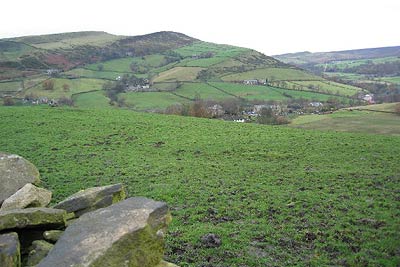
Using the train service along the Hope Valley, this linear Peak District walk from New Mills to Edale gives the opportunity to enjoy some fine Peak District scenery on the edge of Kinder without the need of a car.
The walk starts at New Mills Central station (Grid ref. SJ996853). Turn left out of the station entrance and after 50m, descend a steep path down into the valley. This takes you into the Torrs Country Park, a spectacular gorge at the confluence of the Goyt and Sett rivers and surely one of Derbyshire's best kept secrets. Turn left along the modern walkway constructed for the millennium which soars high above the Goyt offering a fine bird's eye view of the falls below.
Follow the path to the confluence of the Goyt and Sett but do not cross the river. Keep left below the rocky walls along the bank of the Sett going under the railway bridge and where the river disappears into a tunnel, climb up to join the route of the former Hayfield branch railway which emerges from a blocked tunnel to your left (Grid ref. 001855).
From here, it's an easy walk along the old railway trackbed to Hayfield, now designated as the Sett Valley trail. The suburbs of New Mills are quickly left behind and Lantern Pike comes into view to the left. As Hayfield is approached, Kinder looms up ahead giving a promise of the pleasures to come.
The trail ends at Hayfield car park Cross the A624 and turn right up Church Street past the George Hotel. After a further 50m bear left down Valley Road, following it to the end where it becomes a track. It continues along the bank of Kinder Brook past the camp site to emerge at the junction of Kinder Road at Bowden Bridge (Grid ref. 049870). We are now of course on hallowed ground, as the adjacent car park is on the site of the quarry where in 1932 Benny Rothman and the other participants in the Kinder Trespass assembled prior to their historic walk. Also worthy of note is the old Pack Horse bridge which spans Kinder brook just before it joins the river Sett.
For those who have become complacent about the relative ease of the route so far, more serious work begins at this point. Bear right along the lane and after 400m reach a path junction where you take the bridleway which climbs to Tunstead Clough Farm. Continue up past the front of the house crossing a number of stiles to reach a path junction at Grid ref. 058867.
At this point go half right towards a stile visible in the far wall. Keep ahead on the clear path which gently rises up the hill. As you climb, superb views open out to the right over Mount Famine and South Head, while behind Hayfield village and the more distant Greater Manchester conurbation can be seen. Ahead, Kinder Low End towers over you but worry not, you're not going over it!
Keep straight on ignoring paths to left and right to reach the stony track up Oaken Clough at a Peak and Northern Footpaths Society sign at Grid ref. 073862. Continue up the track to reach the summit at Edale Cross. The Pennine Way can be seen descending from Swine's Back to your left and after a further 350m we join it for the remainder of the walk to Edale. The route down Jacob's Ladder and on to Edale is familiar to all; suffice to say that it offers a fine end to a splendid walk.
The excellent local train service between Sheffield and Manchester along the Hope Valley connects the start and finish points at two hourly intervals (including Sunday). On Saturday, the frequency is doubled to hourly. Full timetable details can be found on the Derbyshire Journey Planner.
Other walks nearby
| Walk 2523 | Black Rocks & Bollinhurst Reservoir | easy | 5.0 miles |
| Walk 2567 | Lyme Park & Dissop Head | easy | 6.0 miles |
| Walk 2546 | Lantern Pike & Cown Edge from Rowarth | easy/mod | 8.0 miles |
| Walk 2507 | South Head & Edale Cross from Hayfield | moderate | 8.0 miles |
| Walk 2329 | The Disley Lanes from Lyme Park | easy | 4.0 miles |
| Walk 1474 | Park Moor and Birchencliff from Lyme Park | easy/mod | 7.3 miles |
| Walk 1481 | Dale Top (Park Moor) from Lyme Park | easy | 6.3 miles |
| Walk 3407 | Chinley to Edale without a car | moderate | 9.3 miles |
| Walk 2534 | Chinley Churn & South Head | easy/mod | 7.5 miles |
| Walk 1174 | Kinder Low & Mount Famine | moderate | 7.5 miles |
Recommended Books & eBooks
Great Mountain Days in the Pennines
 An inspirational guidebook to 50 classic walks on the rolling Pennine landscape. The graded routes, between 6 and 13 miles in length, cover classic Pennine fells and moorland such as Whernside, Ilkley Moor and Pendle Hill; exploring the North and South Pennines, Yorkshire Dales, Howgills and Dark Peak. Many routes are also suited to fell running.
More information
Walking in the Peak District - White Peak East
 Guidebook describing 42 half-day and day walks in the limestone landscapes of Derbyshire's White Peak, part of the Peak District National Park. One of two volumes, this book covers the east of the region, with potential bases including Bakewell, Eyam, Castleton, Birchover, Matlock and Wirksworth.
More information
Messaging & Social Media
Message Walking Britain and follow the latest news.

Mountain Weather
Stay safe on the mountains with detailed weather forecasts - for iOS devices or for Android devices.