Broadstone Hill & the Cotton Famine Road
South Pennines Walk
Nat Park - Peak District - Black Hill Dovestone
Region - South Pennines
County/Area - Greater Manchester
Author - Peter Schofield
Length - 7.0 miles / 11.4 km Ascent - 1000 feet / 303 metres
Time - 4 hours 30 minutes Grade - moderate
Maps 

| Ordnance Survey Explorer OL1 | Sheet Map | 1:25k | BUY |
| Anquet OS Explorer OL1 | Digital Map | 1:25k | BUY |
| Ordnance Survey Landranger 110 | Sheet Map | 1:50k | BUY |
| Anquet OS Landranger 110 | Digital Map | 1:50k | BUY |
Walk Route Description
Click image to visit gallery of 5 images.
The industrial town of Oldham is unlikely to be a place associated by many with either national parks or good walking. Yet 31 sq km (about 2%) of the Peak District National Park lies within the Oldham boundary, almost all of it consisting of peat moorland typical of the Dark Peak. This walk, much of which is on paths not shown on the ODL1 Dark Peak map, offers a glimpse into the history of this relatively little known area at the north western extremity of the Peak.
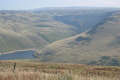
This Peak District walk starts at Binn Green car park (GR SE018044). From the car park entrance turn right up the A635 for 600m to a stile from where a waymarked path goes up towards Alderman Hill. Approximately half way up the hill side, turn right on to a path which climbs to a group of rocks at GR016052. As you climb, extensive views open out over the Chew Edges and across Greenfield Reservoir towards Holme Clough, a place we will visit later on the walk. Beyond it, Black Hill and the transmitter at Holme Moss are prominent to the east.
From the rocks, a clear path heads up the hill towards a fence. As the path bears right and levels out, walk across the moor to a gas pipeline marker situated alongside a track at GR015055. Go left down the track for 100m and then right on to a clear path at an Oldham Way signpost. Follow this path along the ridge from where the attractive villages of Saddleworth can be seen spread out in the valleys below.
At a gully where the Oldham Way starts to descend (GR017062), continue on the path along the ridge to the trig point at Broadstone Hill which is visible ahead. A number of paths radiate from here, and you should continue along one heading off on a bearing of approximately sixty degrees from the trig point.
After 300m, a shallow boggy ditch is crossed and the path turns right on the far side. The ditch is all that remains of the Cotton Famine Road, construction of which was undertaken to provide employment for local textile workers when the supply of raw cotton dried up during the American Civil War. The ditch drives relentlessly on over the featureless wastes and one can only imagine the terrible conditions under which people must have toiled during the building this "road to nowhere". The atmosphere of despair doesn't lift until the paved route of the original Pennine Way is joined which is followed for a short distance to a small car park on the A635 at the Kirklees / Oldham boundary.
Turn right and walk along the road for 400m to a stile located on the south side at GR047062. From here, there are no visible paths so the easiest way to proceed is to follow a bearing of 220 degrees to a fence corner at GR045058. Continue along the fence line with Rimmon Pit Clough to your left and where the fence goes right at the ruins of Rimmon Cottage, go straight ahead over two small streams and continue along the ridge. Rimmon Pit Clough is seen descending rapidly to join Holme Clough but you should continue along the ridge without losing height as walking at stream level is difficult.
The route swings to the right towards Standing Stones while views open out across the reservoirs and the Chew Edges. Continue along the ridge towards Standing Stones until the gradient of the hillside to your left eases and it becomes safer to descend to the valley below. Descend over the open moorland to cross the stream at the confluence of Birchen and Holme Cloughs (GR038050). From here, the route is easy to follow along the water company track past Greenfield and Yeoman Hey reservoirs to the dam where the track changes to tarmac. Follow it for a further 300m to a gate on the right from where a short path ascends through a wood to the start point.
For public transport users, the nearest bus stop is at the Clarence Hotel at Greenfield from where it's a 1.7K walk up the A635 to Binn Green. Frequent buses link Greenfield with Oldham, Manchester and other local towns and details can be found on the Greater Manchester PTE website at www.gmpte.com.
Note However John Illingworth says "I am afraid this description perpetuates a myth about the road on Saddleworth Moor being a Cotton Famine Road" constructed in the 1860s to alleviate the unemployment in the cotton industry caused by the Union's embargo on the export of cotton from the Confederacy during the American Civil War. However, the ditches alongside can be seen on the 1854 OS map and it is probably an unfinished road from Saddleworth village to Blake Gate, proposed c1811.
Other walks nearby
| Walk 2517 | Chew Reservoir & Fox Stone from Dovestones | moderate | 7.5 miles |
| Walk 2553 | Greenfield Reservoir & Raven Stones from Dovestone | moderate | 8.0 miles |
| Walk 2914 | The Pots & Pans from Uppermill | easy/mod | 4.5 miles |
| Walk 2600 | Chew Reservoir & the Pennine Way | mod/hard | 14.0 miles |
| Walk 2518 | Black Hill & Four Reservoirs from near Wessenden Head | moderate | 10.0 miles |
| Walk 2561 | Digley & Ramsden Reservoirs from Wessenden Head | moderate | 9.5 miles |
| Walk 3607 | Reservoirs Walk from Tintwistle | easy/mod | 5.5 miles |
| Walk 1179 | Lad's Leap & Laddow Rocks from Crowden | moderate | 6.5 miles |
| Walk 2621 | Black Hill & Laddow Rocks | moderate | 9.0 miles |
| Walk 3022 | Black Hill | moderate | 9.0 miles |
Recommended Books & eBooks
Dark Peak Walks
 Guidebook to 40 walks in the Dark Peak area of the Peak District National Park. 35 circular routes for most abilities, from 8km to 19km, around Edale, Marsden, Fairholmes, Baslow and Castleton, including Kinder Scout and Mam Tor, and 5 longer (25km to 45km) routes highlighting the best of the Gritstone Edges, High Moorland and Deep Valleys.
More information
Walking in the Peak District - White Peak East
 Guidebook describing 42 half-day and day walks in the limestone landscapes of Derbyshire's White Peak, part of the Peak District National Park. One of two volumes, this book covers the east of the region, with potential bases including Bakewell, Eyam, Castleton, Birchover, Matlock and Wirksworth.
More information
Messaging & Social Media
Message Walking Britain and follow the latest news.

Mountain Weather
Stay safe on the mountains with detailed weather forecasts - for iOS devices or for Android devices.