Herefordshire Beacon from British Camp car park
Malvern Hills Walk
Region - Malvern Hills
County/Area - Worcestershire & Herefordshire
Author - Lou Johnson
Length - 2.0 miles / 3.3 km Ascent - 500 feet / 152 metres
Time - 1 hours 30 minutes Grade - easy
Maps 

| Ordnance Survey Explorer 190 | Sheet Map | 1:25k | BUY |
| Anquet OS Explorer 190 | Digital Map | 1:25k | BUY |
| Ordnance Survey Landranger 150 | Sheet Map | 1:50k | BUY |
| Anquet OS Landranger 150 | Digital Map | 1:50k | BUY |
Walk Route Description
Click image to visit gallery of 6 images.
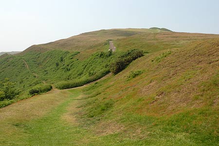
The Malvern Hills form an impressive line of summits, the highest point of which is the Worcestershire Beacon at the northern end of the range. Generally speaking the hills get lower as you go south. This short walk concentrates on the Herefordshire Beacon, which rises to 338 metres above sea level. Paths are well maintained and easy to follow.
The walk starts from the car park (Grid ref. SO762403) on the south side of the A449 Malvern to Ledbury road at British Camp. Space is limited, so on fine days parking may be problematic. On the opposite side of the main road is a café serving refreshments and ice-cream in season. Near the entrance to the car park is an information board outlining the history of British Camp. This Iron Age Hill Fort dates from 200 BC and occupies much of the Herefordshire Beacon, which this walk climbs and explores.
Leave the car park by taking the tarmac path uphill onto the Herefordshire Beacon opting for the higher path by forking right. This climb soon offers some excellent views along the main ridge of the Malvern Hills as well as offering an interesting insight into the substantial earthworks and defensive ditches of British Camp. The summit (338 m.) is soon reached and offers a grandstand view of the surrounding area, something which the builders of fort had clearly understood.
To continue the walk, descend south from the summit crossing Millennium Hill onto Broad Down. Below to your right is British Camp Reservoir. Stay on the main ridge and continue south to reach Hangman's Hill, which makes an ideal place to take a break with extensive views in all directions. This is as far south as the walk goes. To return to the start, retrace your steps to reach Broad Down. Rather than re-ascend the Herefordshire Beacon fork right from the ridge path and take the well made path that crosses the flanks of this hill. This leads easily back to the car park.
Other walks nearby
| Walk 2380 | The Malverns from the Gullet | moderate | 12.0 miles |
| Walk 1211 | The Worcestershire Beacon | easy/mod | 4.5 miles |
| Walk 2326 | Herefordshire Beacon from Hollybush | easy/mod | 6.5 miles |
| Walk 1556 | The Malverns - end to end | hard | 10.0 miles |
| Walk 1658 | Malverns circular from Noirth Hill | very hard | 18.0 miles |
| Walk 2483 | Cradley Circular | easy/mod | 6.0 miles |
| Walk 2445 | Upton-upon-Severn Circular | easy/mod | 6.8 miles |
| Walk 1870 | Dymock Daffodil Walk | easy/mod | 9.0 miles |
| Walk 1516 | Pershore Circular | easy/mod | 8.3 miles |
| Walk 2817 | The Marcle Ridge from Much Marcle | easy/mod | 7.0 miles |
Recommended Books & eBooks
No suggestions for this area.Messaging & Social Media
Message Walking Britain and follow the latest news.

Mountain Weather
Stay safe on the mountains with detailed weather forecasts - for iOS devices or for Android devices.