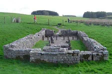
Hadrian's Wall and Haughton Common from Brocolitia Fort
Northumberland Walk
Nat Park - Northumberland
County/Area - Northumberland County
Author - Peter Lane
Length - 20.0 miles / 32.5 km Ascent - 2200 feet / 667 metres
Time - 12 hours 10 minutes Grade - hard
Maps 

| Ordnance Survey Explorer OL43 | Sheet Map | 1:25k | BUY |
| Anquet OS Explorer OL43 | Digital Map | 1:25k | BUY |
| Ordnance Survey Landranger 87 | Sheet Map | 1:50k | BUY |
| Anquet OS Landranger 87 | Digital Map | 1:50k | BUY |
Walk Route Description
Click image to visit gallery of 9 images.
A lengthy walk through some desolate moorland, forest land and one of the best preserved sections of Hadrian's Wall. Many antiquities can be visited along the route including Housesteads Roman Fort, so allow plenty of time for browsing. Much use is made of the Pennine Way and the Hadrian's Wall National Trail.
This challenging walk can be started at Steel Rigg or from Brocolitia Fort. This description leaves the spectacular Wall walk to last and starts at Brocolitia Fort, grid reference NY861712. Park in the lay-by for Brocolitia Fort on the B6318 and explore the Fort and Mithraeum Temple. Exit the area over a stile and continue on the Hadrian's Wall National Trail (acorn symbol) until reaching the road. Cross and take the bridlepath opposite heading NNW.
Cross the Crook Burn via a footbridge and upon reaching Greenhaugh, proceed along the access road as it turns to the left towards Stooprigg, leaving this track for a path heading down to the right as the access road turns left again. Follow this through a gate and then onto the open wilderness of Simonburn Common, part of Haughton Common. The path is moderately discernible in good visibility, but a map and compass are essential here. In the mist it would be best to turn back. Follow the path all the way to the forest ahead, keeping the woods to your left until reaching a minor tarmac road on the edge of Broadpool Common.
Walk along the road until you pick up the Pennine Way feeding in from the right and proceed for a further 200 metres or so to a rising footpath rising on the left, which is the continuation of the Pennine Way heading South. Route finding is now straightforward: follow the Pennine Way through the woods until it emerges at Hawk Side. Continue to follow the Pennine Way across to the next patch of woodland until it emerges onto moorland heading South again to Cragend. Enjoy the views to Greenlee Lough along the way.
From Cragend take the steep hill heading left and then swinging right at the top, continuing South as the Pennine Way. Leave the Pennine Way as a footpath feeds off to the right rising gently uphill towards the 277m spot height on the OS map. Follow this and after the path turns left, look out for a footpath heading right across fields. Cross the stile and proceed past Peatrigg to a track joining from the right that emerges at a minor road. Turn left up the tarmac road to the car park at Steel Rigg (near Once Brewed) on top of the hill.
The route is now along the Hadrian's Wall National Trail all the way back to Brocolitia Fort. Follow the acorn symbols and the fairly obvious "Wall"! The route sticks close to the wall, mainly with the wall to the left. After switching sides, take care to switch back again when double fingerposts are seen either side of the wall, this avoids an unnecessary scramble back!
At Sewing Shields, a parallel lower footpath can be used to return towards the main road if desired. The National Trail continues on the left side of the road without incident until reaching Carraw, where it runs three sides of the property before returning to the outward bridlepath heading NNW. Return to Brocolitia here, retracing the outward route to your car.
Other walks nearby
| Walk 1786 | Hadrian's Wall & Simonburn circular | easy/mod | 6.8 miles |
| Walk 3331 | Cragend & Crow Crags from Housesteads | easy/mod | 8.4 miles |
| Walk 1677 | Peel Crags & Winshield Crags from Vindolanda | easy/mod | 7.8 miles |
| Walk 2671 | Hotbank Crags & Housesteads from Vindolanda | easy | 5.3 miles |
| Walk 1198 | Hadrian's Wall & Steel Rigg | moderate | 8.0 miles |
| Walk 2337 | Greenlee Lough and Steel Rigg | easy/mod | 7.5 miles |
| Walk 3404 | Hadrian's Wall - Cawfields to Steel Rigg | easy/mod | 3.5 miles |
| Walk 1477 | Bellingham to Kiln Rigg by Pennine Way Circular | moderate | 14.3 miles |
| Walk 1478 | Ladyhill to Bellingham circular | moderate | 16.0 miles |
| Walk 1987 | Allendale Town Circular | easy/mod | 6.6 miles |
Recommended Books & eBooks
Walking in Northumberland
 This guidebook contains detailed route descriptions for 36 day walks in Northumberland including the Cheviot Hills. The terrain varies from wild walks and craggy ascents to gentle riverside strolls. Each route ranges from 4 to 16 miles in length and there is the opportunity to link several walks together to create longer treks.
More information
Hadrian's Wall Path
 Hadrians Wall Path guidebook to walk the 84 mile National Trail. Described in both directions, the main description is west to east between Bowness-on-Solway and Wallsend, Newcastle, with extensions to Maryport and South Shields. With extensive historical information related to this World Heritage site and separate 1:25,000 OS map booklet included.
More information
Messaging & Social Media
Message Walking Britain and follow the latest news.

Mountain Weather
Stay safe on the mountains with detailed weather forecasts - for iOS devices or for Android devices.