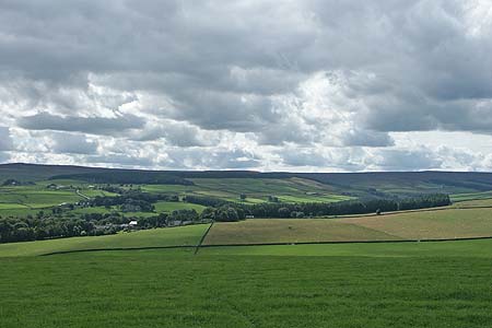
Pennypie and Blanchland from Baybridge
North Pennines Walk
Region - North Pennines
County/Area - Northumberland County & Durham
Author - Lou Johnson
Length - 3.8 miles / 6.1 km Ascent - 650 feet / 197 metres
Time - 2 hours 30 minutes Grade - easy/mod
Maps 

| Ordnance Survey Explorer OL43 | Sheet Map | 1:25k | BUY |
| Anquet OS Explorer OL43 | Digital Map | 1:25k | BUY |
| Ordnance Survey Landranger 87 | Sheet Map | 1:50k | BUY |
| Anquet OS Landranger 87 | Digital Map | 1:50k | BUY |
Walk Route Description
Click image to visit gallery of 3 images.
This walk starts in the Derwent Valley and climbs onto the fringes of the moors before dropping down into the valley at the picturesque village of Blanchland. There is ample opportunity to explore the village before return along the River Derwent back to the start.
The start is the car park and picnic area alongside the River Derwent at Baybridge (Grid ref. NY957499). After parking, exit onto the road and turn left. Turn left again into the lane that runs in front of the cottages and begin the steady climb out of the valley onto the moor. The lane is quite steep in places and with excellent views up valley you have ample excuses to stop and admire the view. Passing the access road to Birkside Farm on your left the climb is nearly over. Reaching a bridleway sign (Grid ref. NY951508), continue straight ahead across the moor to reach the track in front of Pennypie House (Grid ref. NY949517).
Turn sharp right here and follow the lane through the hamlet of Shildon and down the small side valley into Blanchland. This village is picturesque, historic and unusual with many of its stone buildings around the perimeter of a large cobbled square. Blanchland Stores and the old post office are two buildings of note and with two places offering refreshments there is ample excuse to stay awhile and explore.
To continue, walk south through the main square and follow the road south to cross the River Derwent into County Durham. Just over the bridge turn right onto the signed footpath. This path leads through pleasant woodland offering views to the river and beyond. After approximately one kilometre the path reaches a road. Turn right here, cross the river again and the car park is on your left.
Other walks nearby
| Walk 3315 | Warlaw Pike & Birkside Fell from Blanchland | moderate | 8.0 miles |
| Walk 3722 | Buckshott Fell & Sikehead Mines | easy/mod | 6.5 miles |
| Walk 2089 | College Edge & Cuthbert's Currick from Edmundbyers | easy/mod | 8.0 miles |
| Walk 1942 | Watson's Pike & Hexhamshire Common | easy/mod | 6.0 miles |
| Walk 2382 | Smiddy Shaw Reservoir Circular | easy/mod | 6.2 miles |
| Walk 2393 | Weardale Circular from Westgate | easy/mod | 6.4 miles |
| Walk 1987 | Allendale Town Circular | easy/mod | 6.6 miles |
| Walk 3634 | Catterick Moss & Bollihope Carrs | moderate | 5.6 miles |
| Walk 1659 | Race Head & Sedling Rake from Wearhead | easy/mod | 6.0 miles |
| Walk 1948 | Tunstall Reservoir | easy/mod | 7.3 miles |
Recommended Books & eBooks
Walking in the North Pennines
 This guidebook describes 50 day walks across the North Pennines, England's remotest Area of Outstanding Natural Beauty taking in parts of Cumbria, County Durham and Northumberland. Most of the routes are circular and they range from 5 to 14 miles, with something to suit all abilities. Route descriptions are accompanied by 1:50K OS mapping.
More information
Hadrian's Wall Path
 Hadrians Wall Path guidebook to walk the 84 mile National Trail. Described in both directions, the main description is west to east between Bowness-on-Solway and Wallsend, Newcastle, with extensions to Maryport and South Shields. With extensive historical information related to this World Heritage site and separate 1:25,000 OS map booklet included.
More information
Messaging & Social Media
Message Walking Britain and follow the latest news.

Mountain Weather
Stay safe on the mountains with detailed weather forecasts - for iOS devices or for Android devices.