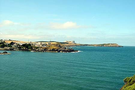
Dinas Gynfor from Cemaes Bay, Anglesey
Isle of Anglesey Walk
County/Area - Isle of Anglesey
Author - Paul Gasson
Length - 4.0 miles / 6.5 km Ascent - 870 feet / 264 metres
Time - 2 hours 50 minutes Grade - easy
Maps 

| Ordnance Survey Explorer 262 | Sheet Map | 1:25k | BUY |
| Anquet OS Explorer 262 | Digital Map | 1:25k | BUY |
| Ordnance Survey Landranger 114 | Sheet Map | 1:50k | BUY |
| Anquet OS Landranger 114 | Digital Map | 1:50k | BUY |
Walk Route Description
Click image to visit gallery of 5 images.
This walk explores a very scenic section of the recently opened Anglesey Coastal Path, visiting an Iron Age promontory fort at the most northerly part of Wales, before returning via an inland footpath.
To reach the start, follow the A5025 from Junction 8 on the A55, then take the second turn right (Llanbadrig) after passing through the village of Bull Bay. Then take the first left to a small car park on the beach (SH374937). From the entrance to the car park take the waymarked footpath left. This rises steeply up rough steps and then follows the cliffs around a small headland, with good views back to Cemaes Bay and Wales' only surviving nuclear power station at Wylfa beyond. Looking South from the path one can see the silvery windmills of two wind power farms, making their tiny but ecologically friendly contribution to Britain's electricity needs. Near the tip of the headland the path descends into a narrow gully leading to a disused quarry, with the remains of an old lime kiln alongside the path. Climbing out of the gully the path continues along the cliff tops , then turns sharply right and joins a lane leading, in a few hundred metres, to Llanbadrig Church. The lane is little used, but is narrow so be aware of possible traffic.
Llanbadrig (The church of St.Patrick), was reputedly founded by St. Patrick after he was shipwrecked nearby whilst returning from a visit to St.Columba in Iona. The story has it that he found shelter from the storm in a cave (there are several locally) and founded the original church as a thanksgiving for his survival. The original church was rebuilt in the 15th.Century, and boasts a 12th.Century font. It was extensively refurbished in the 19th.century by Lord Stanley of Alderley, at his own expense, who wanted the church to reflect his own Islamic faith, which accounts for the predominance of blue inside it.
The path skirts the old churchyard to the left, then turns right to continue its way along the cliff tops, always clear to see on the ground, and well waymarked as part of the 125 mile long Coastal Path around the island. There are a couple of fairly steep rises and descents to ensure you get your full quota of exercise, and all the way in the spring and early summer there is a profusion of wildflowers, including bluebells, primrose, sea campion and thrift. Kestrels, buzzards and occasionally choughs can be seen, and in the distance, to the West, can be seen the Skerries rocks with their lighthouse, and the beacon on the notorious Harry Furlong rocks between the Skerries and Carmel Head. The lighthouse on the Skerries was built in 1714 by a William Trench, who hoped to profit from tolls levied on passing ships, but the venture failed and he died, ruined, in 1729. The lease passed to his daughter, and in time became a very profitable light before eventually being sold to Trinity House in 1841, the last privately owned lighthouse in Britain. It was fully automated and de manned in 1987, and the light can be seen for 22 nautical miles.
The path descends steeply to the inlet of Porth Llanlleiana down some rather incongruous concrete steps, with its ruined building and limekiln and a tall chimney, a left over from the area's china clay industry. Most of the china clay in UK now comes from Cornwall, but the china clay in this area was of high quality, being used mostly in paper making, and also in the manufacture of fine porcelain and pharmaceuticals. Immediately behind the ruined factory the steep rocky promontory of Dinas Gynfor rises some 200ft, the most northerly point of Wales, and the site of an Iron Age hill fort. The promontory is also a Site of Special Scientific Interest for its geological interest, with a well exposed meeting of the underlying and very ancient Mona Complex rocks with the younger Lower Ordovician rocks, laid down some 490 million years ago.
A steep, stepped path leads up onto the promontory from the seaward end of the building, then turns left to head for a dilapidated brick 'summerhouse', built to celebrate the coronation of Edward VII in 1901. This view point gives wonderful views East and West along the rugged coast, and, in clear weather northwards to the Isle of Man and the Cumberland hills (but be warned, if the views are that clear, rain is likely within a few hours!) After taking in the views continue eastwards on the clear path until it joins another path climbing steeply up from the inlet of Porth Cynfor or Hell's Mouth. The walk can easily be extended along the cliffs to Porth Wen, but our way turns sharply right along the path rising from Hells Mouth, to drop steadily back down the hillside to a marsh, close to the old china clay works visited earlier. The earthworks for the hill fort, defending this slope are still visible, but during the summer are largely obscured by a lush growth of bracken. The marsh is crossed on a stone causeway, and the path continues straight ahead, keeping the wall to your right, until it joins a metalled lane via a kiss gate, hidden away in the corner of the field.
On the lane, go right for about 300 metres until a footpath sign directs you over a stile to your left, and a path drops down the field to a footbridge. Continue straight ahead, heading for a house up ahead, and pass through the grounds of the house via two stiles. Up on the hillside to the right you can see the grapevines of the Gwinllan Padrig Vineyard, well worth a stop before you leave the area for its wine sales, vineyard and winery tours, as well as teas and coffees. After crossing the second stile by the house, don't continue up the obvious rising track ahead, but leave it right to meet a wall (waymark), which is followed through an area of small trees and shrubs to rejoin the lane close to the start of the walk. Go right on the road, and then left at the T junction to get back to your car. If you decide to visit the vineyard for refreshments it is signed from the T junction.
Other walks nearby
| Walk 3580 | Carmel Head & the Skerries from near Cemlyn Bay | easy | 4.5 miles |
| Walk 3040 | Church Bay & Mynydd y Garn from Swtan | easy/mod | 6.0 miles |
| Walk 3039 | Holyhead Mountain | easy/mod | 4.5 miles |
| Walk 1702 | Rhoscolyn Headland | easy | 5.5 miles |
| Walk 3043 | Llanddwyn Island from Newborough | easy | 4.0 miles |
| Walk 1315 | Drosgl and Gyrn Wigau from Rachub | moderate | 7.5 miles |
| Walk 2833 | Moel Faban, Gyrn & Moel Wnion from Rachub | easy/mod | 5.0 miles |
| Walk 3020 | Aber Falls, Foel-fras & Drum | mod/hard | 9.0 miles |
| Walk 3021 | Northern Carneddau | mod/hard | 12.0 miles |
| Walk 2346 | Yr Orsedd ridge from near Bont Newydd | moderate | 4.8 miles |
Recommended Books & eBooks
No suggestions for this area.Messaging & Social Media
Message Walking Britain and follow the latest news.

Mountain Weather
Stay safe on the mountains with detailed weather forecasts - for iOS devices or for Android devices.